Tioga in Williams County, North Dakota — The American Midwest (Upper Plains)
Betaini Norwegian Lutheran Church
Photographed by Cosmos Mariner, June 30, 2024
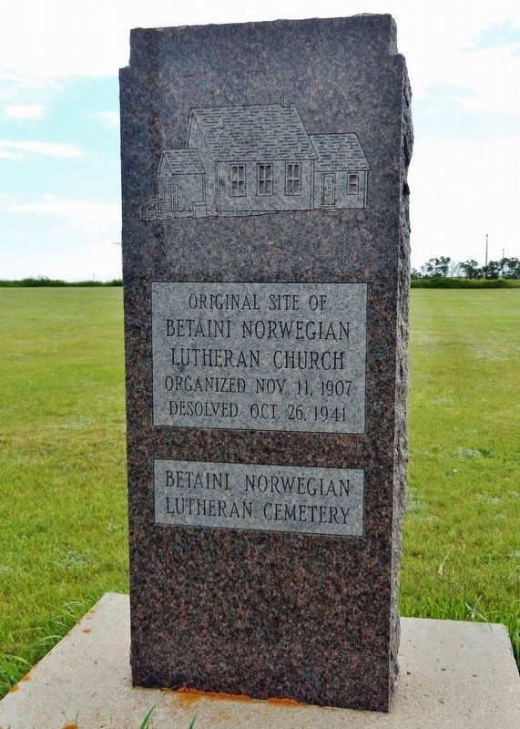
1. Betaini Norwegian Lutheran Church Marker (south marker)
[south marker]
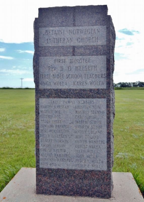
Betaini Norwegian Lutheran Church
Organized Nov. 11, 1907
Desolved Oct. 26, 1941
Betaini Norwegian Lutheran Cemetery
Rev. H. O. Helseth
First Bible School Teachers
Inga Wolla, Karen Wolla
Early Family Members
Topics and series. This historical marker is listed in these topic lists: Cemeteries & Burial Sites • Religion & Religious Structures • Settlements & Settlers. In addition, it is included in the Norwegian-Americans series list. A significant historical date for this entry is November 11, 1907.
Location. 48° 16.149′ N, 102° 57.418′ W. Marker is in Tioga, North Dakota, in Williams County. It is on 105th Avenue Northwest (County Highway 21) just south of 59th Street Northwest, on the
this page online

Regionally, this marker is in the Bakken Oil Patch. It is also in the American Lewis & Clark Corridor, on the prairies, and on the Northern Plains. Globally, it is in North America, the Western Hemisphere, the Western World, and the Anglosphere. Historically, it finds itself in what was once Rupert’s Land and also the Louisiana Purchase.
Other nearby markers. At least one other marker is within 14 miles of this marker, measured as the crow flies: Tobacco Garden Bay (approx. 13.3 miles away).
Also see . . .
1. Betaini Lutheran Cemetery (also known as Bethany Lutheran Cemetery) (Find A Grave). Excerpt:
The cemetery was near the church (which no longer stands) and is well maintained and burials are still being made there today.(Submitted on July 31, 2024, by Cosmos Mariner of Cape Canaveral, Florida.)
2. Norwegian-American Lutheranism (Wikipedia). Excerpt:
Most Norwegian immigrants to the United(Submitted on July 31, 2024, by Cosmos Mariner of Cape Canaveral, Florida.)States, particularly in the migration wave between the 1860s and early 20th century, were members of the Church of Norway, an evangelical Lutheran church established by the Constitution of Norway. As they settled in their new homeland and forged their own communities, however, Norwegian-American Lutherans diverged from the state church in many ways, forming synods and conferences that ultimately contributed to the present Lutheran establishment in the United States.Photographed by Cosmos Mariner, June 30, 20242. Betaini Norwegian Lutheran Church Marker (north marker)

Photographed by Cosmos Mariner, June 30, 2024
3. Betaini Norwegian Lutheran Church Marker(s)
Looking east from 105th Avenue Northwest. Former site of Betaini Norwegian Lutheran Church.

Photographed by Cosmos Mariner, June 30, 2024
4. Betaini Lutheran Cemetery (also known as Bethany Lutheran Cemetery)
Looking south from of 59th Street Northwest. 105th Avenue Northwest is on the right. The markers are visible in the right background.
Credits. This page was last revised on July 31, 2024. It was originally submitted on July 31, 2024, by Cosmos Mariner of Cape Canaveral, Florida. This page has been viewed 227 times since then and 28 times this year. Photos: 1, 2, 3, 4. submitted on July 31, 2024, by Cosmos Mariner of Cape Canaveral, Florida.
