Norwich in Norfolk, England, United Kingdom — Northwestern Europe (the British Isles)
Elm Hill
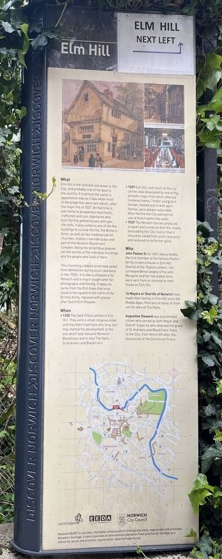
Photographed by Ray Gurganus, March 25, 2024
1. Elm Hill Marker
What
Elm Hill is the loveliest old street in the City, and probably one of the best in the country. It is almost the same in appearance now as it was when most of the properties were last rebuilt, after the major fire of 1507. At that time it was home to prosperous merchants, craftsmen and civic dignitaries who built the fine jettied houses with pantile roofs. It also contains one of the few buildings to survive the fire, the Briton's Arms, as well as two medieval parish churches, historic riverside quays and part of the Norwich Blackfriars' complex. Along the street blue plaques tell the stories of the individual buildings and the people who lived in them.
This charming cobbled street was saved from demolition during slum clearance in the 1920s. It is now a showpiece for Norwich and is much sought after for photography and filming. It takes its name from the Elm trees that once stood in the square to the north of the Britons Arms, replaced with planes after Dutch Elm Disease.
When
• 1258 The Sack Friars settled in Elm Hill. They were a small religious order and they didn't last here very long, but they started the development of the site which later became Norwich Blackfriars and is now The Halls - St Andrew's and Blackfriars'
• 1507 Elm Hill, and much of the city centre, was devastated by one of the periodic major fires which affected medieval towns. Timber and thatch houses, heated and lit with open flames, were always vulnerable. After the fire the City banned the use of thatch within the walls.
• 1927 The Norwich Society produced a report and survey on Elm Hill, finally persuading the City Council that it should be saved from slum clearance and restored to its former glory.
Who
John Paston Sr (b.1481) was probably the first member of the famous Paston family to own a house in Elm Hill. Several
this page online
16 Mayors or Sheriffs of Norwich have made their homes in Elm Hill since the Middle Ages. Portraits of many of them can be seen at The Halls.
Augustine Steward was a prominent citizen who served as both Mayor and Sheriff. It was he who obtained the grant of St Andrew's and Blackfriars' Halls to the City, from Henry VIII after the dissolution of the Dominican Friary.
Topics. This historical marker is listed in these topic lists: Religion & Religious Structures • Roads & Vehicles • Settlements & Settlers. A significant historical year for this entry is 1507.
Location. 52° 37.85′ N, 1° 17.782′ E. Marker is in Norwich, England, in Norfolk. It is on Princes Street, on the left when traveling east. Touch for map. Marker is at or near this postal address: 4 Princes Street, Norwich, England NR3 1AZ, United Kingdom. Touch for directions.

Regionally, this marker is in East Anglia. Globally, it is on the Atlantic Ocean, in the North Atlantic Region, in Europe, in Atlantic Europe, on one of the British Isles, in the Western World, and in the Anglosphere. Historically, it finds itself in what was once the Roman Empire.
Other nearby markers. At least 8 other markers are within walking distance of this marker: St Christopher's Church (here, next to this marker); United Reformed Church (within shouting distance of this marker); St Peter Hungate (within shouting distance of this marker); Paston House (about 90 meters away, measured in a direct line); Wrights Court (about 150 meters away); Augustine Steward House (about 180 meters away); a different marker also named Elm Hill (about 180 meters away); Edith Cavell (about 210 meters away). Touch for a list and map of all markers in Norwich.
Credits. This page was last revised on August 1, 2024. It was originally submitted on August 1, 2024, by Ray Gurganus of Washington, District of Columbia. This page has been viewed 140 times since then and 23 times this year. Photo 1. submitted on August 1, 2024, by Ray Gurganus of Washington, District of Columbia. • Andrew Ruppenstein was the editor who published this page.
