Bremen in Washington County, Kansas — The American Midwest (Upper Plains)
Wagons Merge on the Prairie
Photographed by Jeremy Snow, July 19, 2024
1. Wagons Merge on the Prairie Marker
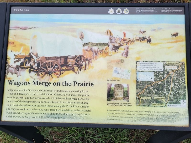
Wagons bound for Oregon and California left Independence starting in the 1840s and developed a trail to this location. Others started across the prairie from St. Joseph, and Fort Leavenworth. All of that traffic merged here at the junction of the Independence and St. Joe Roads. From this point the shared route headed northwesterly across Nebraska along the Platte River corridor. The wagons would share the same route from here until they reached western Wyoming, where again the routes would split. In the 1860s, the Pony Express and the Overland Stage would follow this route as well.
Westward from here the tallgrass prairie began changing to shortgrass plains. Approaching the Platte, emigrants wrote in their journals of seeing buffalo and antelope for the first time. Water and trees became scarcer and emigrants began collecting buffalo chips to fuel their campfires
Caption Marker placed here in 1947 by the American Pioneer Trails Association.
Topics and series. This historical marker is listed in this topic list: Roads & Vehicles. In addition, it is included in the Oregon Trail, and the Pony Express National Historic Trail
this page online
Location. 39° 52.264′ N, 96° 48.374′ W. Marker is in Bremen, Kansas, in Washington County. It is on 1st Road, on the right when traveling east. Touch for map. Marker is at or near this postal address: 998 1st Rd, Bremen KS 66412, United States of America. Touch for directions.

Regionally, this marker is in Eastern Kansas. It is also in the American Midwest, in the Corn Belt, on the prairies, and on the Southern Plains. Globally, it is in North America, the Western Hemisphere, the Western World, and the Anglosphere. Historically, it finds itself in what was once the Louisiana Purchase.
Other nearby markers. At least 8 other markers are within 4 miles of this marker, measured as the crow flies: Trail Junction (a few steps from this marker); Hollenberg Ranch Pony Express Station (approx. 2.8 miles away); Points of Interest (approx. 2.9 miles away); Hollenberg Station and Transportation (approx. 2.9 miles away); Transportation (approx. 2.9 miles away); Camping Along the Trail (approx. 2.9 miles away); Hollenberg Pony Express Station (approx. 3 miles away); Hollenberg Ranch and the Pony Express (approx. 3.6 miles away).
Credits. This page was last revised on August 5, 2024. It was originally submitted on August 4, 2024, by Jeremy Snow of Cedar City, Utah. This page has been viewed 223 times since then and 38 times this year. Photo 1. submitted on August 4, 2024, by Jeremy Snow of Cedar City, Utah. • J. Makali Bruton was the editor who published this page.
