Sault Ste. Marie in Algoma District, Ontario — Central Canada (North America)
1870
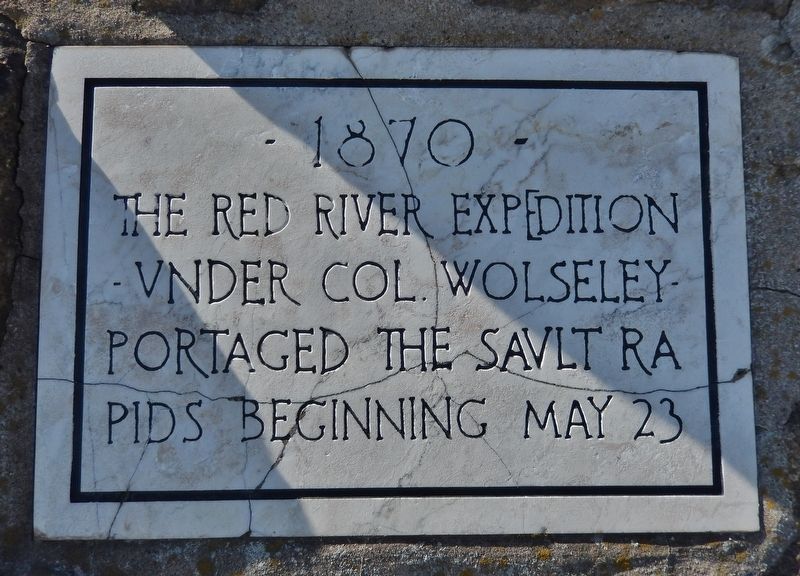
Photographed by Cosmos Mariner, June 10, 2024
1. 1870 Marker
Topics. This historical marker is listed in these topic lists: Exploration • Waterways & Vessels. A significant historical date for this entry is May 23, 1870.
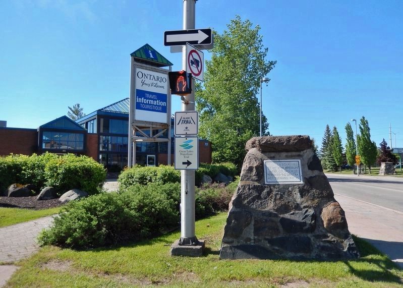
Location. 46° 31.098′ N, 84° 20.862′ W. Marker is in Sault Ste. Marie, Ontario, in Algoma District. It is at the intersection of Queen Street West and Huron Street, on the left when traveling west on Queen Street West. The marker is located at the southeast corner of the intersection, directly in front of the Ontario Travel Information Centre. Touch for map. Marker is at or near this postal address: 261 Queen Street West, Sault Ste Marie ON P6A 1A3, Canada. Touch for directions.

Regionally, this marker is in the Sault Ste. Marie and Algoma Area and in Northern Ontario. It is also in Central Canada. Globally, it is in North America, in the Great North Woods, on the Great Lakes, on Lake Superior’s North Shore, in the Western Hemisphere, in the Western World, and in the Anglosphere. Historically, it finds itself in what was once a British colony, the Viceroyalty
this page online
Other nearby markers. At least 8 other markers are within walking distance of this marker: To The Voyageurs (within shouting distance of this marker); The First Sault Ste. Marie Canal (approx. 0.3 kilometers away); Sault Ste. Marie World War II Memorial (approx. 0.3 kilometers away); 1783 (approx. 0.3 kilometers away); 1821 (approx. 0.3 kilometers away); Francis Hector Clergue (approx. 0.4 kilometers away); The North West Company Post (approx. 0.4 kilometers away); 70th Anniversary Dutch-Canadian Friendship Tulip Garden (approx. half a kilometer away). Touch for a list and map of all markers in Sault Ste. Marie.
Also see . . .
1. Wolseley Expedition (Wikipedia).
Excerpt: The Wolseley expedition was a military force authorized by Canadian Prime Minister John A. Macdonald to confront Louis Riel and the Métis in 1870, during the Red River Rebellion, at the Red River Colony in what is now the province of Manitoba. The expedition was also intended to counter American expansionist sentiments in northern border states. Leaving Toronto in May, the expedition(Submitted on August 12, 2024, by Cosmos Mariner of Cape Canaveral, Florida.)travelled to Georgian Bay, then by steamer across Lake Huron to the U.S. Sault Canal where men and materiel had to be transported on the Canadian side of the river. The two steamers hired by the Canadian government were the Algoma and the Chicora. The St. Marys canal went through the territory of the United States, critical to moving supplies northward. The first steamer, the Algoma, made it through before the Chicora was stopped. American border agents stopped the steamers due to the movement of soldiers and the materials of war, which were viewed as a threat. Wolseley then arranged the 4.8 km portage of the soldiers and materials upriver on the Canadian side of the river to be loaded back onto the awaiting Algoma. The expedition arrived, after a three-month journey in arduous conditions, at Fort Garry on August 24.Photographed by Cosmos Mariner, June 10, 20242. 1870 Marker CairnLooking south along Huron Street from Queen Street West.
2. The Red River Expedition of 1870 (By Paul Mcnicholls).
Excerpt: The American closure of their canal at Sault Ste. Marie resulted in a delay until an agreement could be worked out. The decision to close the canal to the expedition had, in fact, come from President Grant. After receiving direction from the Governor-General in Ottawa, the minister persuaded Grant to rescind his order and open the canal, but with the condition that no troops or military supplies could be onboard when the steamers passed through.(Submitted on August 12, 2024, by Cosmos Mariner of Cape Canaveral, Florida.)
Credits. This page was last revised on August 12, 2024. It was originally submitted on August 12, 2024, by Cosmos Mariner of Cape Canaveral, Florida. This page has been viewed 149 times since then and 19 times this year. Photos: 1, 2. submitted on August 12, 2024, by Cosmos Mariner of Cape Canaveral, Florida.
