Ipswich in Essex County, Massachusetts — The American Northeast (New England)
Along The Ipswich River
ca. 1860
Photographed by Marc Posner, July 8, 2024
1. Along The Ipswich River Marker
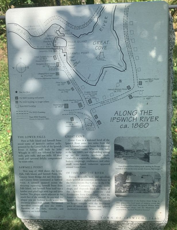
The Lower Falls
Here at Falls Island and Sawmill Point stood some of Ipswich’s earliest mills, powered by the Lower Falls of the Ipswich River. A fulling mill built by John Whipple in 1673 was followed by hemp mills, grist mills, and saw mills. All were small and operated fitfully, compromised by ocean tides.
Sawmill Point
This map of 1860 shows the Lower Falls, Falls Island, and Sawmill Point. The County Street Bridge did not exist, and County Street terminated at Sawmill Point. A sawmill spanned across the sluiceway separating Sawmill Point from Falls Island, and Sawmill Point itself was a lumber yard piled high with logs and sawn lumber. This plaque stands adjacent to the south face of the sawmill. As you read the plaque you are looking north across the sluiceway toward Falls Island. The sawmill operation continued into the 1880’s. Remains of the dam, seawalls, and sluiceway are visible today.
Great Cove
Great Cove is a widened bend of the Ipswich River some two miles from the sea. It formed a natural home for shipping and its related trades. Wharves were built in the late 1600’s, and shipbuilding sprang
this page online
Fishing, shopcrafts, trade, and agriculture made Ipswich an economic powerhouse in the Massachusetts Bay Colony in the 17th and 18th Centuries. Wharves, mills, shops, and shipyards lined the banks of the Ipswich River upstream and downstream from the Great Cove. After the American Revolution, Great Cove and the Ipswich River – shallow and tidal – could no longer compete with the deep-water ports of Salem and Boston, and Ipswich declined in economic importance.
( photo captions )
— View of Sawmill Point looking north, showingthe Damon Sawmill of 1870 and the stone seawall. (Courtesy of Bill George.)
— The construction of the County Street Bridge in 1861 geneated a brief spurt of industry across the street from Sawmill Point: the Ipswich Woolen Mills, two wheelwright shops, and the blacksmith shop pictured here. (Ipswich Historical Society.)
Erected 2005 by Town of Ipswich.
Topics. This historical marker is listed in

Photographed by Marc Posner, July 8, 2024
2. Along The Ipswich River Marker
Location. 42° 40.695′ N, 70° 50.103′ W. Marker is in Ipswich, Massachusetts, in Essex County. It is on County Street north of Elm Street, on the right when traveling north. Touch for map. Marker is in this post office area: Ipswich MA 01938, United States of America. Touch for directions.

Regionally, this marker is on the North Shore, in Greater Boston, and in the Merrimack Valley. It is also in the American Northeast, in New England, and on the Eastern Seaboard. Globally, it is in the North Atlantic Region, North America, the Western Hemisphere, the Western World, and the Anglosphere. Historically, it finds itself in what was once one of the original Thirteen Colonies.
Other nearby markers. At least 8 other markers are within walking distance of this marker: Sawmill Point (a few steps from this marker); Ipswich House (within shouting distance of this marker); The District (about 500 feet away, measured in a direct line); Ipswich Veterans Memorial (about 600 feet away); Ipswich Massachusetts Village Green Memorial

Photographed by Marc Posner, July 8, 2024
3. Along The Ipswich River Marker

Photographed by Marc Posner, July 8, 2024
4. Along The Ipswich River Marker
Credits. This page was last revised on August 24, 2024. It was originally submitted on August 13, 2024, by Marc Posner of Somerville, Massachusetts. This page has been viewed 312 times since then and 56 times this year. Photos: 1, 2, 3, 4. submitted on August 13, 2024, by Marc Posner of Somerville, Massachusetts. • Michael Herrick was the editor who published this page.
