Sylvan Park in Nashville in Davidson County, Tennessee — The American South (East South Central)
McConnell Field

Photographed by Darren Jefferson Clay, July 13, 2024
1. McConnell Field Marker
Nashville, TN- McConnell Field became Nashville's first municipal airport after the city purchased the 131 acres of land along Richland Creek from Warren Sloan in 1927. The airport was named for Lt. Brower McConnell, a pilot in the Tennessee National Guard's 105th squadron, who died in an air crash in 1927. The 105th squadron relocated to McConnell field for training in 1928. It was understood that a pilot who learned to fly at McConnell could fly anything. The railroad embankments on the south end as well as the greenhouses on the east created landing hazards. Overshooting the railroad embankment meant perhaps a dip in the Cumberland River on the far side, reports a McConnell Pilot. In McConnell Field days, with few restrictions and even fewer instruments, the best trained aviators flew their small planes by what was known as "seat-of-the-pants" intuition,
"it was understood that a pilot who learned to fly at McConnell could fly anything"
Airmail
Nashville's first airmail and passenger flight took off from McConnell Field on December 1st, 1928. A Fairchild FC-2W named "Miss Chattanooga," carrying two passengers
this page online
Planes Outgrow Runway
The size of airplanes quickly outgrew the runways at McConnell Field. Before long traffic began shifting to Sky Harbor in Murfreesboro. Berry Field, today's Nashville International Airport, was under construction in 1936. In 1937 McConnell Field was officially decommissioned. McConnell Field was transferred to the city park system in 1938, adjoining parcels were purchased expanding the park area to 209 acres. The airport was renamed McCabe Park in honor of Charles M. McCabe who was the Nashville Park Commissioner and died in 1939. The first playground at McCabe Park, the athletic field and the nine-hole golf course, were constructed by the Works Progress Administration (WPA). The second nine holes were constructed

Photographed by Darren Jefferson Clay, July 13, 2024
2. McConnell Field Marker
Captions
(Top left): Lt. Brower McConnell, right, with Mechanic James Wilson, 1926. (Source: Banner 17 Aug 88.)
(Right middle): Louis Gasser, Nashville's first commercial pilot at McConnell Field ca 1930. The aircraft is a 1929 Command-Aire 5C3-C with a 5 cylinder, 165-hp Wright 16 engine. (Source: Fulbright, J. Aviation in Tennessee, 1998)
(Bottom center): Pre-McConnell Field 1927. (Source :Metro Archives, Nashville Public Library
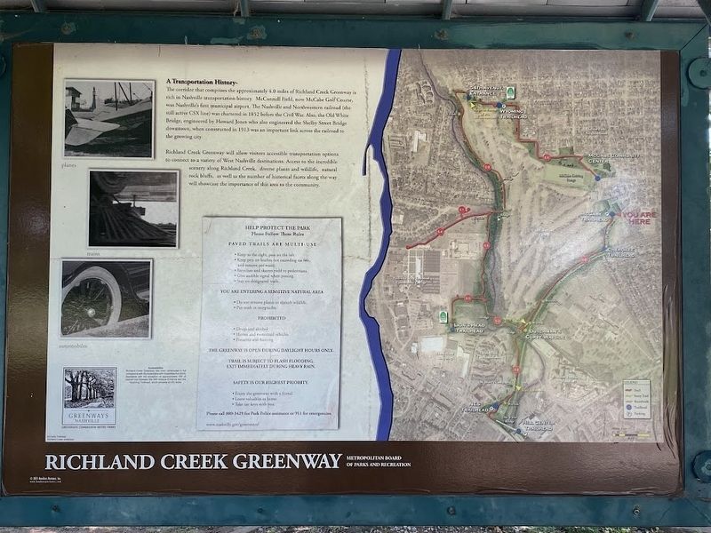
A Transportation History-
The corridor that comprises the approximately 4.0 miles of Richland Creek Greenway is rich in Nashville transportation history. McConnell Field, now McCabe Golf Course, was Nashville's first municipal airport. The Nashville and Northwestern railroad (the still active CSX line) was chartered in 1852 before the Civil War. Also, the Old White Bridge, engineered by Howard Jones who also engineered the Shelby Street Bridge downtown, when constructed in 1913 was an important link across the railroad to the growing city. Richland Creek Greenway will allow visitors accessible transportation options
Photographed by Darren Jefferson Clay, July 13, 2024
3. McConnell Field Marker
Topics. This historical marker is listed in these topic lists: Air & Space • Parks & Recreational Areas • Railroads & Streetcars.
Location. 36° 8.336′ N, 86° 50.497′ W. Marker is in Nashville, Tennessee, in Davidson County. It is in Sylvan Park. It is on Sloan Road west of Westlawn Drive, on the right when traveling west. Touch for map. Marker is at or near this postal address: 4617 Sloan Rd, Nashville TN 37209, United States of America. Touch for directions.

Regionally, this marker is in Middle Tennessee. It is also in the American South and specifically in the Upper South. Globally, it is in North America, the Western Hemisphere, the Western World, and the Anglosphere. Historically, it finds itself in what was once the territory of the Mississippian Culture, one of the Confederate States
Photographed by Darren Jefferson Clay, July 13, 2024
4. McConnell Field Marker
Other nearby markers. At least 8 other markers are within walking distance of this marker: A different marker also named McConnell Field (about 400 feet away, measured in a direct line); a different marker also named McConnell Field (approx. 0.2 miles away); Sylvan Park School (approx. 0.4 miles away); The Craighead House (approx. 0.6 miles away); Johnson's Station (approx. 0.6 miles away); Montgomery Bell Academy (approx. 0.6 miles away); Vine Street Christian Church (approx. 0.6 miles away); Russ McCown (approx. ¾ mile away). Touch for a list and map of all markers in Nashville.
Credits. This page was last revised on July 23, 2025. It was originally submitted on August 13, 2024, by Darren Jefferson Clay of Duluth, Georgia. This page has been viewed 296 times since then and 63 times this year. Photos: 1, 2, 3, 4. submitted on August 13, 2024, by Darren Jefferson Clay of Duluth, Georgia. • James Hulse was the editor who published this page.
