
Medora in Billings County, North Dakota — The American Midwest (Upper Plains)
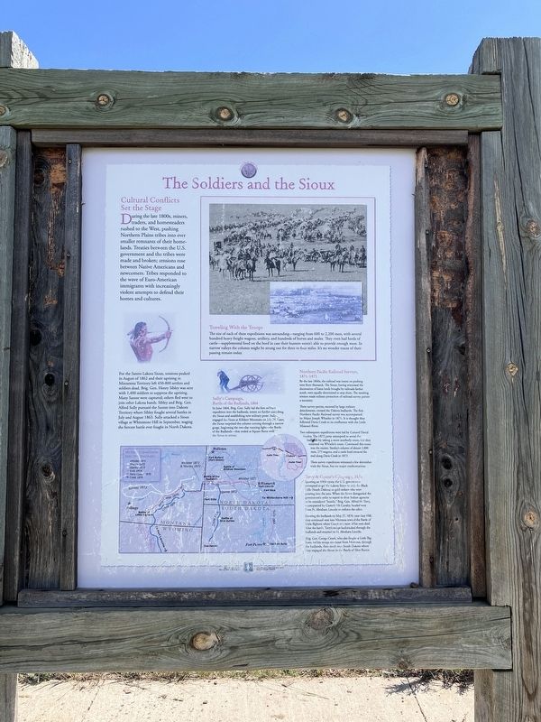
The Soldiers and the Sioux
⎯⎯⎯
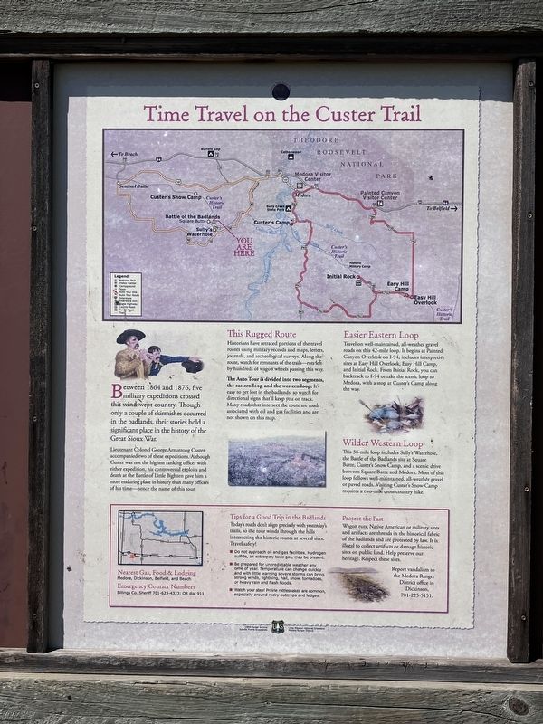
Time Travel on the Custer Trail
Cultural Conflicts Set the Stage
Photographed by Barry Swackhamer, July 6, 2024
1. The Soldiers and the Sioux panel
Cultural Conflicts Set the Stage
For the Santee Lakota Sioux, tensions peaked in August of 1865 and their uprising in Minnesota Territory left 450-800 settles and soldiers dead. Brig. Gen. Henry Sibley was sent with 1,400 soldiers to suppress the uprising. Many Santee were captured; others fled west to join other Lakota bands. Sibley and Brig. Gen. Alfred Sully pursued the Santee into Dakota Territory where Sibley fought several battles in July and August 1863. Sully attacked a Sioux village at Whitestone Hill in September, waging the fiercest battle ever fought in North Dakota.
Sully's Campaign, Battle of the Badlands, 1864
In June 1864, Brig. Gen. Sully led the first military
this page online
Northern Pacific Railroad Surveys, 1871-1873
By the late 1860s, the railroad was intent on pushing west from Bismarck. The Sioux, having witnessed the decimation of bison herds brought by railroad farther south, were equally determined to stop them. The resulting tension made military protection of railroad survey parties a necessity.
Three survey parties, escorted by large military detachments, crossed the Dakota badlands. The first Northern Pacific Railroad survey was accompanied by Major Joseph Whistler in 1871. It is thought they followed Davis Creek to its confluence with the Little Missouri River.
Two subsequent expeditions were led by Colonel David Stanley. The 1872 party attempted to avoid the badlands by taking a more southerly route, but they returned via Whistler's
Photographed by Barry Swackhamer, July 6, 2024
2. Time Travel on the Custer Trail panel
These survey expeditions witnessed a few skirmishes with the Sioux, but no major confrontations.
Terry & Custer's Campaign, 1876
Ignoring an 1868 treaty, the U.S. government attempted to get the Lakota Sioux to cede the Black Hills (South Dakota) to gold seekers who were pouring into the area. When the Sioux disregarded the government's order to report to their Indian agencies or be considered "hostile," Brig Den Alfred H. Terry accompanied by Custer's 7th Cavalry, headed west from Fort Abraham Lincoln to enforce the edict.
Entering the badlands on May 27, 1876, near Easy Hill, they continued west into Montana toward the Battle of Little Bighorn were Custer and more of his men died. After the battle, Terry's troops backtracked through the badlands and returned to Ft. Abraham Lincoln.
Brig. Gen. George Crook, who also fought at Little Bighorn, led his troops northeast from Montana, through the badlands, then south into South Dakota where they engaged the Sioux
Photographed by Barry Swackhamer, July 6, 2024
3. The Soldiers and the Sioux/Time Travel on the Custer Trail Marker
[Sidebar:]
Traveling With the Troops
The size of each of these expeditions was astounding - ranging from 600 to 3,300 men, with several hundred heavy freight wagon, artillery, and hundreds of horses and mules. They even had herds of cattle - supplemental food in case their hunters weren't able to provide enough meat. In narrow valleys, the column might be strung out for three to four miles. It's no wonder traces of their passing remain today.
Lieutenant Colonel George Armstrong Custer accompanied two of these expeditions. Although Custer was not the highest ranking officer with either expedition, his controversial exploits and death at the Little Bighorn gave him a more enduring place in history than many officers of his time – hence the name of this tour.
This rugged Route
Historians have retraced portions of the travel routes using military records and maps, letters, journals, and archeological surveys. Along the route, watch for remnants of the trail – ruts left by hundreds of wagon wheels passing this way.
The Auto Tour is divided into two segments, the eastern loop and the western loop. It’s easy to get lost in the badlands, so watch for directional signs that’ll keep you on track. Many roads that intersect the route are roads associated with oil and gas facilities and are not shown on this map.
Easier Eastern Loop
Travel on well-maintained, all-weather gravel roads on this 42-mile loop. It begins at Painted Canyon Overlook on I-94, includes interpretive sites on East Hill Overlook, Easy Hill Camp, and Initial Rock. From Initial Rock, you can backtrack to I-94 or take the scenic loop to Medora, with a stop at Custer’s Camp along the way.
Wilder Western Loop
This 38-mile loop includes Sully’s Waterhole, the Battle of the Badlands site at Square Butte, Custer’s Snow Camp, and a scenic drive between Butte and Medora. Most of this loop follows well-maintained, all-weather gravel or paved roads. Visiting Custer’s Snow Camp requires a two-mile cross-country hike.
Erected by Forest Service, U.S. Department of Agriculture.
Topics. This historical marker is listed in this topic list: Wars, US Indian. A significant historical date for this entry is August 8, 1864.
Location. 46° 51.856′ N, 103° 40.004′ W. Marker is in Medora, North Dakota, in Billings County. It is on Forest Road 750-1 near West River Road (Forest Road 750). Touch for map. Marker is in this post office area: Medora ND 58645, United States of America. Touch for directions.

Regionally, this marker is on North Dakota’s Missouri Plateau. It is also in the American Lewis & Clark Corridor, on the prairies, and on the Northern Plains. Globally, it is in North America, the Western Hemisphere, the Western World, and the Anglosphere. Historically, it finds itself in what was once Rupert’s Land and also the Louisiana Purchase.
Other nearby markers. At least 8 other markers are within 8 miles of this marker, measured as the crow flies: A Skirmish at Sully's Waterhole (here, next to this marker); The Soldiers and the Sioux/Time Travel on the Custer Trail (approx. ¾ mile away); The Shooting of Riley Luffsey (approx. 7.2 miles away); Chateau de Mores (approx. 7.3 miles away); Medora Cemetery (approx. 7.3 miles away); Bad Lands Cantonment (approx. 7.3 miles away); Little Missouri: The Town (approx. 7.3 miles away); Frontier Military (approx. 7.3 miles away). Touch for a list and map of all markers in Medora.
Credits. This page was last revised on January 9, 2026. It was originally submitted on August 17, 2024, by Barry Swackhamer of Brentwood, California. This page has been viewed 286 times since then and 40 times this year. Photos: 1, 2, 3. submitted on August 17, 2024, by Barry Swackhamer of Brentwood, California.
