Canton Industrial Area in Baltimore, Maryland — The American Northeast (Mid-Atlantic)
Historic Canton
Development of the Clinton Street Waterfront
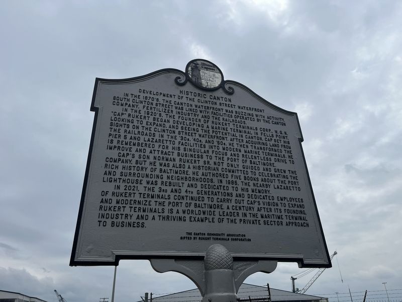
In the 1870's, the Canton waterfront was buzzing with activity South Clinton Street was listed with facilities operated by the Canton Company, fertilizer industry and the railroads.
In the 1920's, the founder of Rukert Terminals Corp., W. G. N. "Cap" Rukert began developing a marine terminal in Fells Point. Looking to expand, and seeing the potential in Canton, Cap set his sights on the Clinton Street waterfront. After acquiring land from the railroads in the '30s, '40s, and '60s, he then transformed the Pier 5 and Lazaretto facilities into modern marine terminals. He is remembered for his singular focus and relentless drive to improve and attract business to the Port of Baltimore.
Cap's son Norman Rukert Sr. not only guided and grew the company, but he was also a historian committed to celebrating the rich history of Baltimore. He authored five books about the Port and surrounding neighborhoods. In 1985, the nearby Lazaretto Lighthouse was rebuilt and dedicated to his memory.
In 2021, the 3rd and 4th generations and dedicated employees of Rukert terminals continued to carry out Cap's visions to expand and modernize
this page online
Erected by The Canton Community Association; gifted by Rukert Terminals Corporation.
Topics. This historical marker is listed in these topic lists: Industry & Commerce • Railroads & Streetcars • Waterways & Vessels. A significant historical year for this entry is 1985.
Location. 39° 15.788′ N, 76° 34.115′ W. Marker is in Baltimore, Maryland. It is in the Canton Industrial Area. It is at the intersection of South Clinton Street and Keith Avenue, on the right when traveling south on South Clinton Street. Touch for map. Marker is at or near this postal address: 2451 S Clinton St, Baltimore MD 21224, United States of America. Touch for directions.

Regionally, this marker is in Central Maryland. It is also in the American Mid-Atlantic, in the Chesapeake Bay Region, and on the Eastern Seaboard. Globally, it is in the North Atlantic Region, North America, the Western Hemisphere, the Western World, and the Anglosphere. Historically,

Other nearby markers. At least 8 other markers are within walking distance of this marker: Four Pounder Cannon (approx. 0.3 miles away); Army "Sailors," Navy "Soldiers" (approx. half a mile away); The Guns that Won the Battle (approx. half a mile away); A Vast Hospital Once Stood Here (approx. half a mile away); You Can Help Save Fort McHenry (approx. 0.6 miles away); O'er the Ramparts We Watch! (approx. 0.6 miles away); The Great Guns of the Fort… The Rodman Cannons (approx. 0.6 miles away); Experimental Carriages (approx. 0.6 miles away). Touch for a list and map of all markers in Baltimore.
Other markers no longer nearby. Port of Baltimore (was approx. half a mile away but has been permanently removed); The Guns That Won the Battle (was approx. half a mile away but has been permanently removed); Sailors Fighting Sailors (was approx. half a mile away but has been permanently removed); Outer Battery (was approx. 0.6 miles away but has been permanently removed).
Credits. This page was last revised on August 17, 2024. It was originally submitted on August 17, 2024, by Devry Becker Jones of Washington, District of Columbia. This page has been viewed 207 times since then and 41 times this year. Photos: 1, 2. submitted on August 17, 2024, by Devry Becker Jones of Washington, District of Columbia.
