
Holladay in Salt Lake County, Utah — The American Mountains (Southwest)
First Utah Pioneer Cemetery Outside Salt Lake City
Photographed by Jeremy Snow, August 19, 2024
1. First Utah Pioneer Cemetery Outside Salt Lake City Marker
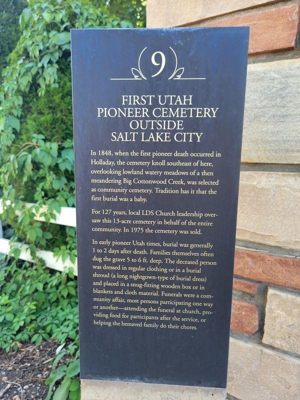
In 1848, when the first pioneer death occurred in Holladay, the cemetery knoll southeast of here, overlooking lowland watery meadows of a then meandering Big Cottonwood Creek, was selected as community cemetery. Tradition has it that the first burial was a baby.
For 127 years, local LDS Church leadership oversaw this 13-acre cemetery in behalf of the entire community. In 1975 the cemetery was sold.
In early pioneer Utah times, burial was generally 1 to 2 days after death. Families themselves often dug the grave 5 to 6 ft. deep. The deceased person was dressed in regular clothing or in a burial shroud (a long nightgown-type of burial dress) and placed in a snug-fitting wooden box or in blankets and cloth material. Funerals were a community affair, most persons participating one way or another-attending the funeral at church, providing food for participants after the service, or helping the bereaved family do their chores.
Erected by Holladay Historical Commission. (Marker Number 9.)
Topics. This historical marker is listed in these topic lists: Cemeteries & Burial Sites • Settlements & Settlers. A significant historical year for this entry is 1848.
Location. 40° 39.804′ N,
this page online

Regionally, this marker is in the Wasatch Front and in Greater Salt Lake. It is also in the American Mountain West and in Colorado Plateau. Globally, it is in North America, the Rocky Mountains, the Western Hemisphere, the Western World, and the Anglosphere. Historically, it finds itself in what was once New Spain and also Mexico’s Alta California.
Other nearby markers. At least 8 other markers are within walking distance of this marker: "Our Sweet Three Year Old Daughter", (about 400 feet away, measured in a direct line); Holladay's First Church and School Building (approx. ¼ mile away); The Lower (or Church) Canal (approx. ¼ mile away); Old Fort Site (approx. 0.3 miles away); Brinton's Blacksmith Shop (approx. 0.4 miles away); Holladay's 1853 Fort (approx. 0.4 miles away); The Expansion of 1849 (approx. 0.4 miles away); Holladay's First General Store
Photographed by Jeremy Snow, August 19, 2024
2. First Utah Pioneer Cemetery Outside Salt Lake City Marker
Credits. This page was last revised on August 21, 2024. It was originally submitted on August 20, 2024, by Jeremy Snow of Cedar City, Utah. This page has been viewed 282 times since then and 37 times this year. Last updated on August 20, 2024, by Jeremy Snow of Cedar City, Utah. Photos: 1, 2. submitted on August 20, 2024, by Jeremy Snow of Cedar City, Utah. • Andrew Ruppenstein was the editor who published this page.
