Montgomery in Montgomery County, Alabama — The American South (East South Central)
Bethel Missionary Baptist Church
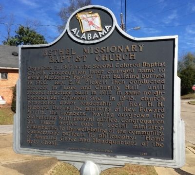
Photographed by Mark Hilton, January 3, 2014
1. Bethel Missionary Baptist Church Marker
Erected 2000 by Alabama Historical Association.
Topics and series. This historical marker is listed in these topic lists: African Americans • Religion & Religious Structures. In addition, it is included in the Alabama Historical Association series list. A significant historical year for this entry is 1867.
Location. 32° 21.793′ N, 86° 19.539′ W. Marker is in Montgomery, Alabama, in Montgomery County. It is at the intersection of Mobile Road and Clio
this page online

Regionally, this marker is in the Tri-Counties River Region. It is also in the American South, specifically in the Deep South, and in the Black Belt. Globally, it is in North America, a Gulf of Mexico state, the Western Hemisphere, the Western World, and the Anglosphere. Historically, it finds itself in what was once the territory of the Mississippian Culture, one of the Confederate States of America, and the Antebellum South.
Other nearby markers. At least 8 other markers are within walking distance of this marker: From Bus Boycott to Voting Rights: Community Activism 1955-65 (approx. 0.2 miles away); Loveless School / Henry Allen Loveless (approx. ¼ mile away); Support: Local and Organizational (approx. ¼ mile away); Percy Lavon Julian, PH.D. (approx. 0.3 miles away); Holt Street Baptist Church (approx. 0.3 miles away); Lilly Baptist Church (approx. 0.3 miles away); Highway Construction Destroys Historic Black Neighborhoods
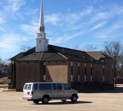
Photographed by Mark Hilton, January 3, 2014
2. Bethel Missionary Baptist Church
Another marker is no longer nearby. Percy Lavon Julian (was approx. 0.3 miles away but has been confirmed missing).
Credits. This page was last revised on August 25, 2024. It was originally submitted on January 3, 2014, by Mark Hilton of Montgomery, Alabama. This page has been viewed 1,440 times since then and 62 times this year. Last updated on August 22, 2024, by Shaun Rose of Montgomery, Alabama. Photos: 1, 2. submitted on January 3, 2014, by Mark Hilton of Montgomery, Alabama. • Devry Becker Jones was the editor who published this page.
