Near Queenstown in Queen Anne's County, Maryland — The American Northeast (Mid-Atlantic)
Stagwell
→
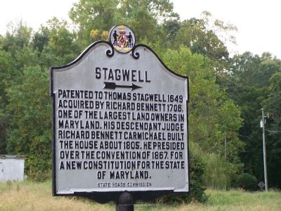
Photographed by Beverly Pfingsten, October 19, 2007
1. Stagwell Marker
Erected 1939 by State Roads Commission.
Topics and series. This historical marker is listed in these topic lists: Colonial Era • Settlements & Settlers. In addition, it is included in the Maryland Historical Trust series list. A significant historical year for this entry is 1649.
Location. This marker has been replaced by another marker nearby. It was located near 38° 56.192′ N, 76° 8.049′ W. Marker was near Queenstown, Maryland, in Queen Anne's County. It was at the intersection of Carmichael Road and Stagwell Road, on the right when traveling south on Carmichael Road. Marker has been replaced with "Site of Stagwell". Touch for map. Marker was at or near this postal address: 1300 Carmichael Rd, Queenstown MD 21658, United States of America. Touch for directions.

Regionally, this marker was on the Eastern Shore. It was also in the American
this page online
Other nearby markers. At least 8 other markers are within 3 miles of this location, measured as the crow flies: Site of Stagwell (a few steps from this marker); “Cheston on Wye” (approx. 0.3 miles away); “Wye Plantation” (approx. 1½ miles away); Wye Island (approx. 1.6 miles away); Governor Robert Wright (approx. 2 miles away); Governor William Grason (approx. 2.1 miles away); Historic Points (approx. 2.4 miles away); “Bloomingdale” (approx. 2½ miles away). Touch for a list and map of all markers in Queenstown.
Related marker. Click here for another marker that is related to this marker. This marker has been replaced with the linked marker, which has a different inscription.
Additional commentary.
1. Glaring errors on this marker
It might seem odd that Richard
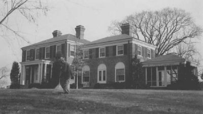
Photographed by State Roads Commission, 1939
2. Stagwell, in 1939
— Submitted November 3, 2007, by Maryland historian of Chestertown, Maryland.
2. Stagwell site
Stagwell was demolished in the 1970s.
— Submitted March 4, 2008, by Christopher Busta-Peck of Shaker Heights, Ohio.
3. Richard Bennett Carmichael
According to my genealogical records, the Richard Bennett Carmichael who built Stagwell was born at Bennett's Choice in Queen Anne’s County on 20 Jan 1752, died 13 Feb 1824 at “Wye,” where he was buried 15 Feb 1824. My understanding is that Thomas Stagwell's patent was on East Wye River, north of William Paca's Wye Plantation on the Wye River. When Judge Richard Bennett Carmichael—the builder’s grandson—inherited “Wye” he called it “Belle Vue,” although I have been unable to find any historical reference to this name.
— Submitted August 20, 2011, by Howard Crise of Baltimore, Maryland.
Credits. This page was last revised on August 24, 2024. It was originally submitted on October 24, 2007, by Bill Pfingsten of Bel Air, Maryland. This page has been viewed 2,031 times since then and 55 times this year. Last updated on August 24, 2024, by Rico Ramirez of Prince Frederick, Maryland. Photos: 1. submitted on October 24, 2007, by Bill Pfingsten of Bel Air, Maryland. 2. submitted on March 3, 2008, by Christopher Busta-Peck of Shaker Heights, Ohio. • Devry Becker Jones was the editor who published this page.
