
Comanche in Comanche County, Texas — The American South (West South Central)
The Comanche
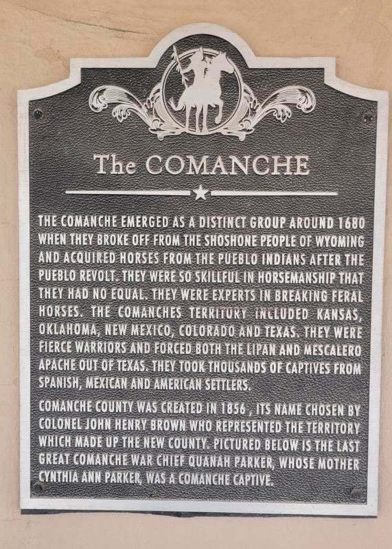
Photographed by James Hulse, August 30, 2024
1. The Comanche Marker
Comanche County was created in 1856, its name chosen by Colonel John Henry Brown who represented the territory which made up the new county. Pictured below is the last great Comanche War Chief Quanah Parker, whose mother Cynthia Ann Parker, was a Comanche captive.
Topics. This historical marker is listed in this topic list: Indigenous Peoples and Communities. A significant historical year for this entry is 1680.
Location. 31° 53.855′ N, 98° 36.31′ W. Marker is in Comanche, Texas, in Comanche County. It is at the intersection of North Houston Street and West Central Street (State Highway 36), on the
this page online

Regionally, this marker is in Big Country. Globally, it is in North America, a Gulf of Mexico state, the Western Hemisphere, the Western World, and the Anglosphere. Historically, it finds itself in what was once New Spain, the Comanchería, the Republic of Texas, and one of the Confederate States of America.
Other nearby markers. At least 8 other markers are within walking distance of this marker: Durham Building (within shouting distance of this marker); Calaboose and rock with irons (within shouting distance of this marker); Old Cora Courthouse (within shouting distance of this marker); Bicentennial Park (within shouting distance of this marker); Robert Thomas Hill (within shouting distance of this marker); General Ashbel Smith, C.S.A. (within shouting distance of this marker); Fleming Oak (within shouting distance of this marker); Indian Raid in Comanche (within

Photographed by James Hulse, August 30, 2024
2. The Comanche Marker at the entrance to the building
Also see . . . Quanah Parker. Wikipedia
Quanah Parker (Comanche: Kwana, lit. 'smell, odor'; c. 1845 – February 23, 1911) was a war leader of the Kwahadi ("Antelope") band of the Comanche Nation. He was likely born into the Nokoni ("Wanderers") band of Tabby-nocca and grew up among the Kwahadis, the son of Kwahadi Comanche chief Peta Nocona and Cynthia Ann Parker, an Anglo-American who had been abducted as an eight-year-old child during the Fort Parker massacre in 1836 and assimilated into the Nokoni tribe. Following the apprehension of several Kiowa chiefs in 1871, Quanah Parker emerged as a dominant figure in the Red River War, clashing repeatedly with Colonel Ranald S. Mackenzie. With European-Americans hunting American bison, the Comanches' primary sustenance, into near extinction, Quanah Parker eventually surrendered and peaceably led the Kwahadi to the reservation at Fort Sill, Oklahoma.(Submitted on August 31, 2024, by James Hulse of Medina, Texas.)

Photographed by James Hulse, August 30, 2024
3. The view of the Comanche Marker from the street
Credits. This page was last revised on August 31, 2024. It was originally submitted on August 31, 2024, by James Hulse of Medina, Texas. This page has been viewed 285 times since then and 31 times this year. Photos: 1, 2, 3. submitted on August 31, 2024, by James Hulse of Medina, Texas.
