Barren Island in Brooklyn in Kings County, New York — The American Northeast (Mid-Atlantic)
Jamaica Bay Greenway
Gateway National Recreation Area
| — | National Park Service, U.S. Department of the Interior | — |
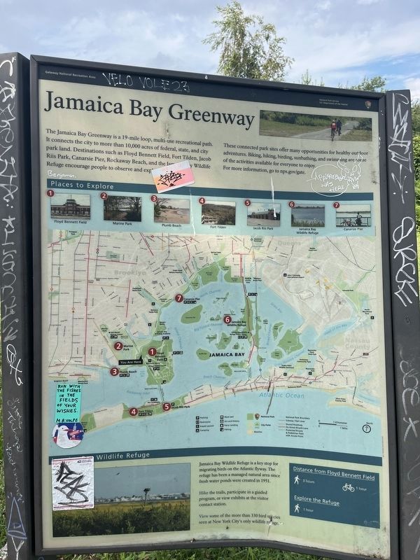
The Jamaica Bay Greenway is a 19-mile loop, multi-use recreational path. It connects the city to more than 10,000 acres of federal, state, and city park land. Destinations such as Floyd Bennett Field, Fort Tilden, Jacob Riis Park, Canarsie Pier, Rockaway Beach, and the Jamaica Bay Wildlife Refuge encourage people to observe and explore.
These connected park sites offer many opportunities for healthy outdoor adventures. Biking, hiking, birding, sunbathing, and swimming are some of the activities available for everyone to enjoy.
For more information, go to nps.gov/gate.
Jamaica Bay Wildlife Refuge
Jamaica Bay Wildlife Refuge is a key stop for migrating birds on the Atlantic flyway. The refuge has been a managed natural area since fresh water ponds were created in 1951.
View some of the more than 330 bird species seen at New York City's only wildlife refuge.
Erected by National Park Service, U.S. Department of the Interior.
Topics. This historical marker is listed in these topic lists: Natural Resources
this page online
Location. 40° 35.625′ N, 73° 54.257′ W. Marker has been reported damaged. Marker is in Brooklyn, New York, in Kings County. It is on Barren Island. It is at the intersection of Flatbush Avenue and Belt Parkway, on the right when traveling north on Flatbush Avenue. Touch for map. Marker is at or near this postal address: 3347 Belt Pkwy, Brooklyn NY 11234, United States of America. Touch for directions.

Regionally, this marker is in New York City and on Long Island. It is also in the American Northeast, in the Mid-Atlantic, and on the Eastern Seaboard. Globally, it is in the North Atlantic Region, North America, the Western Hemisphere, the Western World, and the Anglosphere. Historically, it finds itself in what was once New Netherland and also one of the original Thirteen Colonies.
Other nearby markers. At least 8 other markers are within 2 miles of this location, measured as the crow flies: Gateway to Flight (approx. half a mile away); Floyd Bennett Field / Jamaica Bay Greenway (approx. half a mile away); a different marker also named Gateway to Flight
Credits. This page was last revised on September 2, 2024. It was originally submitted on September 2, 2024, by Devry Becker Jones of Washington, District of Columbia. This page has been viewed 148 times since then and 17 times this year. Photos: 1, 2. submitted on September 2, 2024, by Devry Becker Jones of Washington, District of Columbia.
