Wynne in Cross County, Arkansas — The American South (West South Central)
Captain Jesse W. Wynne Park
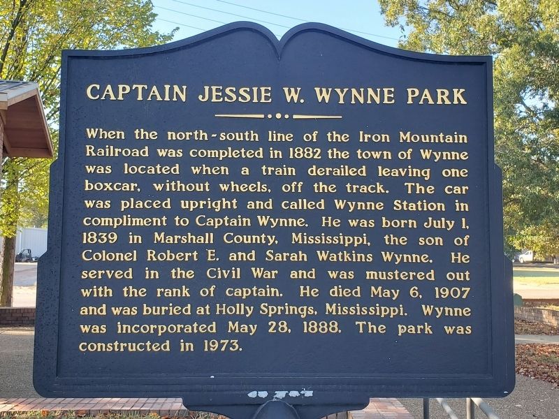
Photographed by Mark Parker, October 6, 2023
1. Captain Jesse W. Wynne Park Marker
Topics. This historical marker is listed in these topic lists: Railroads & Streetcars • Settlements & Settlers • War, US Civil. A significant historical year for this entry is 1882.
Location. 35° 13.427′ N, 90° 47.328′ W. Marker is in Wynne, Arkansas, in Cross County. It is on Merriman Avenue west of South Harris Street. Location of the marker is at the entrance to the park. Touch for map. Marker is at or near this postal address: Merriman Avenue, Wynne AR 72396, United States of America. Touch for directions.

Regionally, this marker
this page online
Other nearby markers. At least 6 other markers are within 14 miles of this marker, measured as the crow flies: Cross County (about 500 feet away, measured in a direct line); Wittsburg in the Civil War (approx. 5 miles away); The Trail of Tears along the Memphis to Little Rock Road (approx. 6.3 miles away); Old Military Road (approx. 6½ miles away); Taylor's Creek and Mount Vernon (approx. 6½ miles away); Mt. Vernon Cemetery (approx. 13.8 miles away).

Photographed by Brandonrush (via Wikimedia Commons), August 21, 2020
2. Jesse Wynne Park in downtown Wynne, Arkansas
This picture was taken just a few steps from the marker location.
Credits. This page was last revised on September 6, 2024. It was originally submitted on September 6, 2024, by Mark Parker of Hickory, North Carolina. This page has been viewed 358 times since then and 80 times this year. Photos: 1. submitted on September 6, 2024, by Mark Parker of Hickory, North Carolina. 2. submitted on September 6, 2024. • Andrew Ruppenstein was the editor who published this page.
