
Front Royal in Warren County, Virginia — The American South (Mid-Atlantic)
Rose Hill
Combat in the Front Yard
| — | Battle of Front Royal — May 23, 1862 | — |
Photographed by Craig Swain, June 29, 2007
1. Rose Hill Marker
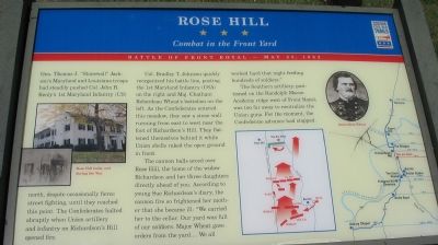
Gen. Thomas J. "Stonewall" Jackson's Maryland and Louisiana troops had steadily pushed Col. John R. Kenly's 1st Maryland Infantry (US) north, despite occasionally fierce street fighting, until they reached this point. The Confederates halted abruptly when Union artillery and infantry on Richardson's Hill opened fire.
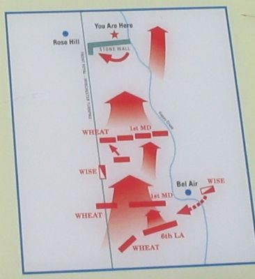
Col. Bradley T. Johnson quickly reorganized his battle line, posting the 1st Maryland Infantry (CSA) on the right and Maj. Chatham Roberdeau Wheat's battalion on the left. As the Confederates entered this meadow, they saw a stone wall running from east to west near the foot of Richardson's Hill. They flattened themselves behind it while Union shells raked the open ground in front.
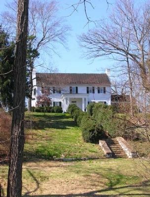
The cannon balls arced over Rose Hill, the home of the widow Richardson and her three daughters directly ahead of you. According to young Sue Richardson's diary, the cannon fire so frightened her mother that she became ill: "We carried her to the cellar. Our yard was full of our soldiers. Major Wheat gave orders from the yard.... We all worked hard that night feeding hundreds of soldiers."
The Southern artillery, positioned on the
this page online
Erected by Virginia Civil War Trails.
Topics and series. This historical marker is listed in this topic list: War, US Civil. In addition, it is included in the Virginia Civil War Trails series list. A significant historical date for this entry is May 23, 1862.
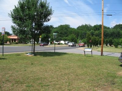
Location. 38° 55.813′ N, 78° 11.563′ W. Marker is in Front Royal, Virginia, in Warren County. It is at the intersection of North Commerce Avenue (U.S. 522) and Hometown Way, on the right when traveling west on North Commerce Avenue. Located at the west side entrance to Lions Community Park. Touch for map. Marker is at or near this postal address: 903 Warren Ave, Front Royal VA 22630, United States of America. Touch for directions.

Regionally, this marker is in the Washington Metropolitan Area and in the Shenandoah Valley. It is also in the American South, specifically in the Upper South, and in the Mid-Atlantic. Globally, it is in North America, the Western Hemisphere, the Western World, and the Anglosphere. Historically,
Photographed by Craig Swain, June 29, 2007
2. Detail of the Tactical Map
Other nearby markers. At least 8 other markers are within walking distance of this marker: Richardson's Hill (approx. half a mile away); Brother Against Brother (approx. half a mile away); Battle of Front Royal (approx. half a mile away); a different marker also named Bel Air (approx. 0.7 miles away); The Great Seal of the Confederacy (approx. ¾ mile away); Erin Dinner Bell (approx. ¾ mile away); Williams Chapel (approx. 0.8 miles away); Race For The River (approx. 0.8 miles away). Touch for a list and map of all markers in Front Royal.
Other markers no longer nearby. Richardson’s Hill (was approx. half a mile away but has been replaced with another marker now near it); Execution of Mosby’s Rangers (was approx. half a mile away but has been permanently removed); Bel Air (was approx. 0.7 miles away but has been replaced with another marker now near it); Mosby’s Men (was approx. ¾ mile away but has been replaced with another marker now near
Photographed by Craig Swain, June 29, 2007
3. Marker at the Park Entrance
Rose Hill is just out of view behind the trees in the distance.
More about this marker. On the left the marker has pictures of "Rose Hill today and during the war." On the right side is a map showing the Battle of Front Royal with tour stops linked to the time line of the battle. A tactical map illustrates the maneuvers described in the text. A portrait of Roberdeau Wheat is between the maps.
Regarding Rose Hill. This marker is one of several from a driving tour of the Front Royal Battlefield. The markers are listed in sequence on the Battle of Front Royal Virtual Tour by Markers link below.
Also see . . .
1. Battle of Front Royal. National Park Service summary of the battle covers the action described on the marker in phase two of the battle. (Submitted on October 14, 2007, by Craig Swain of Leesburg, Virginia.)
2. Rose Hill. Virginia Department of Historic Resources website entry (Submitted on October 14, 2007, by Craig Swain of Leesburg, Virginia.)
3. Battle of Front Royal Virtual Tour by HMDb Markers. (Submitted on November 18, 2007, by Craig Swain of Leesburg, Virginia.)
Additional commentary.
1. Architectural note
The design of the
Photographed by Linda Walcroft, March 9, 2008
4. Rose Hill in 2008
As seen from Royal Avenue (routes 340/522). There is no parking on this busy road but you can park on a side street and walk around the block to see both sides of Rose Hill.
— Submitted March 9, 2008, by Linda Walcroft of Woodstock, Virginia.
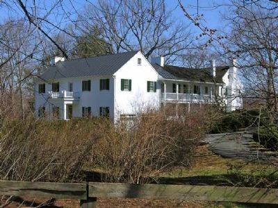
Photographed by Linda Walcroft, March 9, 2008
5. Rose Hill, Side View
Seen from Virginia Avenue. Privately owned.
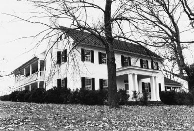
6. Rose Hill
From National Register of Historic Places documentation.
Credits. This page was last revised on August 15, 2025. It was originally submitted on October 14, 2007, by Craig Swain of Leesburg, Virginia. This page has been viewed 3,981 times since then and 123 times this year. Last updated on September 15, 2024, by Carl Gordon Moore Jr. of North East, Maryland. Photos: 1, 2, 3. submitted on October 14, 2007, by Craig Swain of Leesburg, Virginia. 4, 5. submitted on March 9, 2008, by Linda Walcroft of Woodstock, Virginia. 6. submitted on October 14, 2007, by Craig Swain of Leesburg, Virginia. • Bernard Fisher was the editor who published this page.
