Rosendale in Ulster County, New York — The American Northeast (Mid-Atlantic)
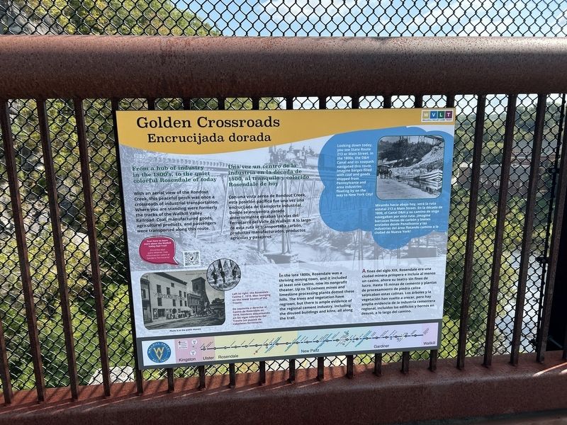
Golden Crossroads
⎯⎯⎯
Encrucijada dorada
Photographed by Steve Stoessel, September 15, 2024
1. Golden Crossroads/ Encrucijada dorada Marker

From a hub of industry in the 1800's, to the quiet colorful Rosendale of today.
With an aerial view of the Rondout Creek, this peaceful perch was once a crossroads of industrial transportation. Where you are standing were formerly the tracks of the Wallkill Valley Railroad. Coal, manufactured goods, agricultural products, and passengers were transported along this route.
In the late 1800s, Rosendale was a thriving mining town, and it included at least one casino, now its nonprofit theater. Up to 15 cement mines and limestone processing plants dotted these hills. The trees and vegetation have regrown, but there is ample evidence of the regional cement industry, including the disused buildings and kilns, all along the trail.
[right inset;]
Looking down today, you see State Route 213 or Main Street. In the 1800s, the D&H Canal and its towpath navigated this route. Imagine barges filled with coal and goods shipped from Pennsylvania and area industries floating by on the way to New York City!
[photos:] Left to right: the Rosendale Casino c. 1919. Men lounging on the lower beams of the Trestle.
Una
this page online
Con una vista aérea de Rondout Creek, esta posición pacífica fue una vez una encrucijada de transporte industrial. Dunde se encuentra parado anteriormente estaban las vías del Ferrocarril del Valle de Wallkill. A lo largo de esta ruta se transportaba carbón, productos manufacturados, productos agrícolas y pasajeros.
A fines del siglo XIX, Rosendale era una ciudad minera próspera e incluía al menos un casino, ahora su teatro sin fines de lucro. Hasta 15 minas de cemento y plantas de procesamiento de piedra caliza salpicaban estas colinas. Los árboles y la vegetación han vuelto a crecer, pero hay amplia evidencia de la industria cementera regional, incluidos los edificios y hornos en desuso, a lo largo del camino.
[ recuadro derecho:]
Mirando hacia abajo hoy, verá la ruta estatal 213 o Main Street. En la década de 1800, el Canal D&H y su camino de sirga navegaban por esta ruta. Imagine barcazas llenas de carbón y bienes enviados desde Pensilvania y las industrias del área flotando camino a la ciudad de Nueva York!
[fotos:] De izquierda a derecha: el Casino de Rosendale c. 1919. Hombres descansando en las vigas inferiores del Trestle (un puente de caballetes ferroviario).
Erected by Wallkill

Photographed by Steve Stoessel, September 15, 2024
2. Looking Past Marker Onto NY 213
A view from the trestle. It is difficult to get a wide view shot in the limited space on the bridge.
Topics. This historical marker is listed in these topic lists: Bridges & Viaducts • Parks & Recreational Areas • Railroads & Streetcars. A significant historical year for this entry is 1800.
Location. 41° 50.617′ N, 74° 5.296′ W. Marker is in Rosendale, New York, in Ulster County. It is on Wallkill Valley Rail Trail half a mile north of Mountain Road, on the right when traveling north. Touch for map. Marker is in this post office area: Rosendale NY 12472, United States of America. Touch for directions.

Regionally, this marker is in Upstate New York and in the Hudson Valley. It is also in the American Northeast, in the Mid-Atlantic, and on the Eastern Seaboard. Globally, it is in the North Atlantic Region, North America, the Western Hemisphere, the Western World, and the Anglosphere. Historically, it finds itself in what was once New Netherland and also one of the original Thirteen Colonies.
Other nearby markers. At least 8 other markers are within walking distance of this marker: D & H Canal (within shouting distance of this marker); Rosendale Tourist Info (approx. 0.6 miles away); Rosendale Library

Photographed by Steve Stoessel, September 15, 2024
3. View of Rondout Creek on Western Side of Trestle.
Also see . . .
1. Wallkill Valley Rail Trail. This is the QR link on marker. (Submitted on September 16, 2024, by Steve Stoessel of Niskayuna, New York.)
2. Wallkill Valley Railroad. (Submitted on September 16, 2024, by Steve Stoessel of Niskayuna, New York.)
Credits. This page was last revised on June 17, 2026. It was originally submitted on September 15, 2024, by Steve Stoessel of Niskayuna, New York. This page has been viewed 171 times since then and 18 times this year. Photos: 1. submitted on September 15, 2024, by Steve Stoessel of Niskayuna, New York. 2, 3. submitted on September 16, 2024, by Steve Stoessel of Niskayuna, New York.
