
Near Van Alstyne in Grayson County, Texas — The American South (West South Central)
Binion Homestead
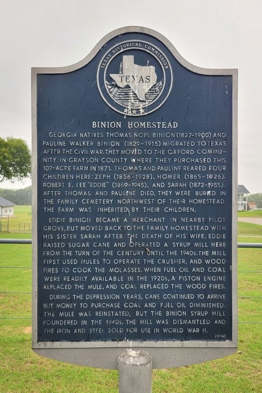
Photographed by James Hulse, September 11, 2024
1. Binion Homestead Marker
Eddie Binion became a merchant in nearby Pilot Grove, but moved back to the family homestead with his sister Sarah after the death of his wife. Eddie raised sugar cane and operated a syrup mill here from the turn of the century until the 1940s. The mill first used mules to operate the crusher, and wood fires to cook the molasses. When fuel oil and coal were readily available in the 1920s, a piston engine replaced the mule, and coal replaced the wood fires.
During the depression years, cane continued to arrive but money to purchase coal and fuel oil diminished. The mule was reinstated, but the Binion Syrup Mill foundered in the 1940s. The mill was dismantled and the iron and steel sold for use in World War II.
Erected 1996 by Texas Historical Commission. (Marker Number 7341.)
Topics. This historical marker is listed in these topic lists: Agriculture • Industry & Commerce • Settlements & Settlers. A significant historical year for this entry is 1871.
Location. 33° 25.415′ N, 96° 26.361′ W. Marker is near Van Alstyne, Texas, in Grayson County. It is on Brewer Road west of Binion Road, on the right when traveling west. The marker is located along the street. Touch for map. Marker is at or near this postal address: 637 Brewer Rd, Van Alstyne TX 75495, United States of America. Touch for directions.

Regionally,
this page online
Other nearby markers. At least 8 other markers are within 6 miles of this marker, measured as the crow flies: Pilot Grove (approx. 1.3 miles away); Pilot Grove Baptist Church (approx. 1.4 miles away); Old Town of Cannon (approx. 2.8 miles away); Bethel Baptist Church (approx. 3.3 miles away); Cannon Cemetery (approx. 3.8 miles away); Elm Grove Cemetery (approx. 4.3 miles away); First National Bank of Trenton (approx. 5.8 miles away); Indian Creek Baptist Church and Cemetery (approx. 5.8 miles away).

Photographed by James Hulse, September 11, 2024
2. The view of the Binion Homestead and Marker from the street
Credits. This page was last revised on September 17, 2024. It was originally submitted on September 16, 2024, by James Hulse of Medina, Texas. This page has been viewed 227 times since then and 38 times this year. Photos: 1, 2. submitted on September 17, 2024, by James Hulse of Medina, Texas.
