Downtown in Fairbanks in Fairbanks North Star Borough, Alaska — Northwest (North America)
Tanana Indians
⎯⎯⎯
Exploration
Historic Fairbanks
Photographed by William Fischer, Jr., August 17, 2024
1. Tanana Indians / Exploration Marker
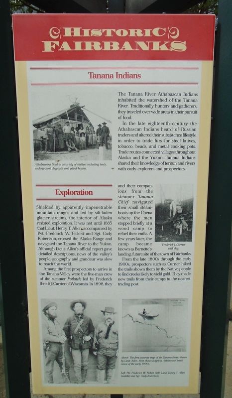
The Tanana River Athabascan Indians inhabited the watershed of the Tanana River Traditionally hunters and gatherers, they traveled over wide areas in their pursuit of food.
In the late eighteenth century the Athabascan Indians heard of Russian traders and altered their subsistence lifestyle in order to trade furs for steel knives, tobacco, beads, and metal cooking pots. Trade routes connected villages throughout Alaska and the Yukon. Tanana Indians shared their knowledge of terrain and rivers with early explorers and prospectors.
[Photo caption reads]
Athabascans lived in a variety of shelters including tents, underground dig outs, and plank houses
Shielded by apparently impenetrable mountain ranges and fed by silt-laden glacier streams, the interior of Alaska resisted exploration. It was not until 1885 that Lieut. Henry T. Allen accompanied by Pvt. Frederick W. Fickett and Sgt. Cady Robertson, crossed the Alaska Range and navigated the Tanana River to the Yukon. Although Lieut. Allen's official report gave detailed descriptions, news of the valley's people, geography and grandeur was slow to reach the world.
Among the first prospectors to arrive in the Tanana Valley were the five-man crew of the steamer Potlatch, led by Frederick (Fred) J. Currier of Wisconsin In 1898, they and their companions from the steamer Tanana Chief navigated their small steamboats up the Chena where the men stopped briefly at a wood camp to refuel their crafts. A few years later, the camp became known as Barnette's landing, future site of the town of Fairbanks.
From the late 1800s through the early 1900s, prospectors such as Currier hiked the trails shown them by the Native people to find creeks likely to yield gold. They made new trails from their camps to the nearest trading post.
[Photo captions, counterclockwise from center right, read]
• Frederick J. Currier with dog.
• Above: The first accurate map of the Tanana River, drawn by Lieut. Allen. Inset shows a typical Athabascan birch canoe of the early 1900s.
• Left: Pvt. Frederick W. Fickett (left), Lieut. Henry T. Allen (middle) and Sgt. Cady Robertson.
Erected by Rotary
this page online
Topics and series. This historical marker is listed in these topic lists: Exploration • Indigenous Peoples and Communities. In addition, it is included in the Rotary International series list. A significant historical year for this entry is 1885.
Location. 64° 50.67′ N, 147° 43.055′ W. Marker is in Fairbanks, Alaska, in Fairbanks North Star Borough. It is in Downtown. It is on Lacey Street north of 1st Avenue, on the right when traveling north. Marker is on the kiosk on the Rabinowitz Courthouse plaza. Touch for map. Marker is at or near this postal address: 101 Lacey Street, Fairbanks AK 99701, United States of America. Touch for directions.

Regionally, this marker is in the Alaska Railroad Corridor, in the Athabascan Region, and in Interior Alaska. It is also on the American Pacific Coast. Globally, it is in North America, on the Pacific Rim, in the Western Hemisphere, in the Western World, and in the Anglosphere. Historically, it finds itself in what was once the Russian Empire.
Other nearby markers. At least 8 other markers are within walking distance of this marker: The Settlement (here, next
Photographed by William Fischer, Jr., August 17, 2024
2. Tanana Indians / Exploration Marker
Also see . . .
1. Tanana (Alaska Native Language Center). University of Alaska website entry (Submitted on September 18, 2024, by William Fischer, Jr. of Reynoldsburg, Ohio.)
2. Exploration and Settlement on the Alaskan Coast. PBS website entry (Submitted on January 26, 2025, by Larry Gertner of New York, New York.)
Credits. This page was last revised on January 26, 2025. It was originally submitted on September 18, 2024, by William Fischer, Jr. of Reynoldsburg, Ohio. This page has been viewed 229 times since then and 35 times this year. Photos: 1, 2. submitted on September 18, 2024, by William Fischer, Jr. of Reynoldsburg, Ohio.
