Henrico in Henrico County, Virginia — The American South (Mid-Atlantic)
Battle of Trent's Reach
Richmond National Battlefield Park
| — | National Park Service, U.S. Department of the Interior | — |
Photographed by Bernard Fisher, June 18, 2012
1. Battle of Trent's Reach Marker
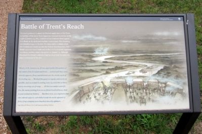
In a daring attempt to attack the Federal supply base at City Point, 11 warships of the James River Squadron ventured downriver on the night of January 23, 1865. Confederate land batteries fired against Fort Brady as the darkened warships steamed past. One incoming shell disabled a gun in the fort. The foray ended in failure when the Confederate vessels ran into the Federal fleet downriver. Fort Brady's gunners stood ready and shelled the Confederate squadron on their return trip upriver on January 25. Although bloodied, Fort Brady’s defenders had survived their first and only major combat test of the war.
“About 3 A.M., January 25, [I] was apprised by [the] pickets of the return of the [Confederate] boats…waited until they came directly opposite, fired, and knocked over the smoke-stack of the leading one…Worked [the guns] as rapidly and surely as possible, and succeeded in sending some 125 solid shot at them before steaming out of range....All this was under a terrific fire, the enemy putting from ten to fifteen hundred heavy shell in and around my battery....But three men, two engineers and one colored support, were killed inside the work; upward of forty of my company were knocked down by splinters....”
Capt. Henry H. Pierce, Co. C, 1st Connecticut Heavy Artillery
Erected 2011
this page online
Topics. This historical marker is listed in these topic lists: Forts and Castles • War, US Civil. A significant historical date for this entry is January 23, 1865.
Location. 37° 23.484′ N, 77° 21.685′ W. Marker is in Henrico, Virginia, in Henrico County. It can be reached from Hoke Brady Road 0.9 miles south of Kingsland Road. Touch for map. Marker is in this post office area: Henrico VA 23231, United States of America. Touch for directions.

Regionally, this marker is in the Piedmont, in Central Virginia, and in the Richmond Metropolitan Area. It is also in the American South, specifically in the Upper South, and on the Eastern Seaboard. Globally, it is in the North Atlantic Region, North America, the Western Hemisphere, the Western World, and the Anglosphere. Historically, it finds itself in what was once the territory of the Mississippian Culture, one of the original Thirteen Colonies, one of the Confederate States of America, and the Antebellum South.
Other nearby markers. At least 8 other markers are within one mile of this marker, measured as the crow flies: Powder Magazine
Photographed by Bernard Fisher, June 18, 2012
2. Fort Brady Trail
Other markers no longer nearby. Inside Fort Brady (was a few steps from this marker but has been replaced with another marker now near it); Guarding the River (was a few steps from this marker but has been replaced with another marker now near it); The Tides (was approx. one mile away but has been permanently removed); Dutch Gap (was approx. one mile away but has been permanently removed); Mount Malady (was approx. one mile away but has been permanently removed); The James River...Floating Through The Centuries (was approx. one mile away but has been permanently removed).
Also see . . .
1. Richmond National Battlefield Park. (Submitted on June 18, 2012.)
2. Desperate Ironclad Assault at Trent's Reach.
Photographed by Bernard Fisher
3. Fort Brady interior view
3. The Richmond Ironclads at Trent's Reach, James River (slide show). Virginia Department of Historic Resources (Submitted on June 18, 2012.)
Credits. This page was last revised on February 23, 2025. It was originally submitted on June 18, 2012, by Bernard Fisher of Richmond, Virginia. This page has been viewed 1,264 times since then and 39 times this year. Last updated on September 21, 2024, by Carl Gordon Moore Jr. of North East, Maryland. Photos: 1, 2. submitted on June 18, 2012, by Bernard Fisher of Richmond, Virginia. 3. submitted on July 11, 2010, by Bernard Fisher of Richmond, Virginia.
