
Henrico in Henrico County, Virginia — The American South (Mid-Atlantic)
Fort Harrison
Richmond Battlefield
| — | Richmond National Battlefield Park 1862•1864 | — |
Photographed by Bill Coughlin, April 24, 2007
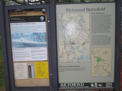
1. Fort Harrison Marker
Fort Harrison stood in 1864 as the most powerful fort in the extensive outer defenses of Richmond. Built on high, open ground, the fort and its surrounding entrenchments were built to protect the approaches to Richmond from the south. The Union army’s strongest probe toward Richmond from this direction occurred on September 29, when General Butler’s Army of the James crossed the river in two columns and struck the defenses here and at New Market Heights to the east. The Union troops captured both targets, but were unable to make any further progress against the smaller fortifications at Fort Gilmer, Fort Gregg, Fort Johnson, and Fort Hoke. Confederate counterattacks the next day failed to recover the lost ground and produced a stalemate that was unbroken until Richmond was evacuated in April 1865.
Although Federal operations here did not achieve the immediate capture of Richmond, the permanent presence of Northern soldiers so close to the capital city did contribute to the extension of the Confederate lines. The fall of Fort Harrison provoked more fighting. Three separate October battles along the Darbytown
this page online
Richmond Battlefields
The national battlefield park contains sites relating to three separate events of the Civil War: the Seven Days Campaign of 1862, the Overland Campaign of 1864, and the late-war fighting north of the James River.
(left panel)
Fort Harrison / Chaffin’s Farm
"There were very many greater fights, and greater numbers killed, during the war, but never was more courage displayed on any field than those men showed in their effort to recapture Fort Harrison. It was a hopeless charge, but it made defeat glorious and Chaffin’s Farm immortal." --2nd Lt. Thomas Porterfield, 2nd Pennsylvania Provisional Heavy Artillery, speaking of the Confederates on September 30, 1864
Erected by National Park Service, U.S. Department of the Interior.
Topics. This historical marker is listed in these topic lists: Forts and Castles • War, US Civil. A significant historical date for this entry is September 29, 1864.
Location. This marker has been replaced by another marker nearby. It was located near 37° 25.684′ N,
Photographed by Bill Coughlin, April 24, 2007
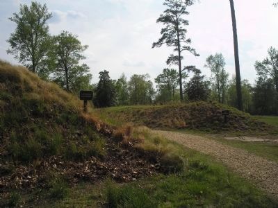
2. Walking Trail through Fort Harrison
The earthworks of the left in this photo were part of Confederate Fort Harrison. Those on the right were part of Federal Fort Burhham, built by Union troops after taking the fort on September 29, 1864.

Regionally, this marker was in Virginia’s Piedmont, in Central Virginia, and in the Richmond Metropolitan Area. It was also in the American South, specifically in the Upper South, and on the Eastern Seaboard. Globally, it was in the North Atlantic Region, North America, the Western Hemisphere, the Western World, and the Anglosphere. Historically, it found itself in what was once the territory of the Mississippian Culture, one of the original Thirteen Colonies, one of the Confederate States of America, and the Antebellum South.
Other nearby markers. At least 8 other markers are within walking distance of this location: A different marker also named Fort Harrison (within shouting distance of this
Photographed by Bill Coughlin, April 24, 2007
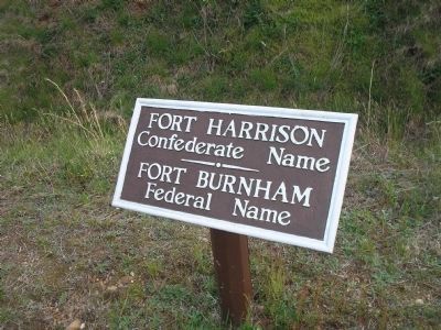
3. Fort Harrison / Burnham
Federal troops successfully took Confederate Fort Harrison on September 29, 1864, and renamed it Fort Burnham.
Another marker is no longer nearby. Fort Harrison Trail (was within shouting distance of this marker but has been replaced with another marker now near it).
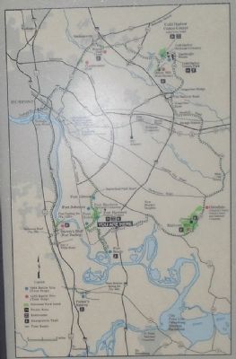
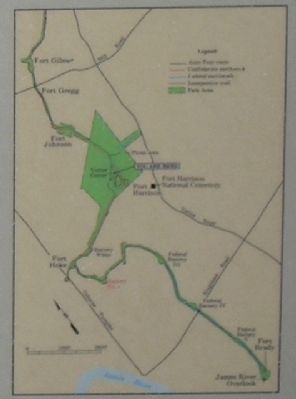
More about this marker. The left of the main marker contains a map of the different units of Richmond National Battlefield Park, with the location of Fort Harrison indicated. The lower right of the marker includes a map of the fortifications from Fort Gilmer to Fort Brady. The left marker features a picture of Union troops fighting off a Confederate counterattack at Fort Harrison.
Related marker. Click here for another

Photographed by Bill Coughlin, April 24, 2007
4. Richmond National Battlefield Park
Marker is in the Fort Harrison Unit of Richmond National Battlefield Park.
Also see . . .
1. Battlefield Tour - Ft Gilmer to Ft Brady. Richmond National Battlefield Park website. (Submitted on January 20, 2009, by Bill Coughlin of Woodland Park, New Jersey.)
2. Fort Harrison. Richmond Battlefields Fort Harrison website. (Submitted on January 20, 2009, by Bill Coughlin of Woodland Park, New Jersey.)
Photographed by Bill Coughlin, April 24, 2007
5. Richmond Battlefields
The national battlefield park contains sites relating to three separate events of the Civil War: the Seven Days Campaign of 1862, the Overland Campaign of 1864, and the late-war fighting north of the James River.
Photographed by Bill Coughlin, April 24, 2007
6. Fort Harrison Area Map from Marker
Credits. This page was last revised on September 24, 2024. It was originally submitted on January 20, 2009, by Bill Coughlin of Woodland Park, New Jersey. This page has been viewed 1,503 times since then and 30 times this year. Last updated on September 23, 2024, by Carl Gordon Moore Jr. of North East, Maryland. Photos: 1, 2, 3, 4, 5, 6. submitted on January 20, 2009, by Bill Coughlin of Woodland Park, New Jersey. • Bernard Fisher was the editor who published this page.
