Brookville Township near Cobden in Redwood County, Minnesota — The American Midwest (Upper Plains)
Dannebod
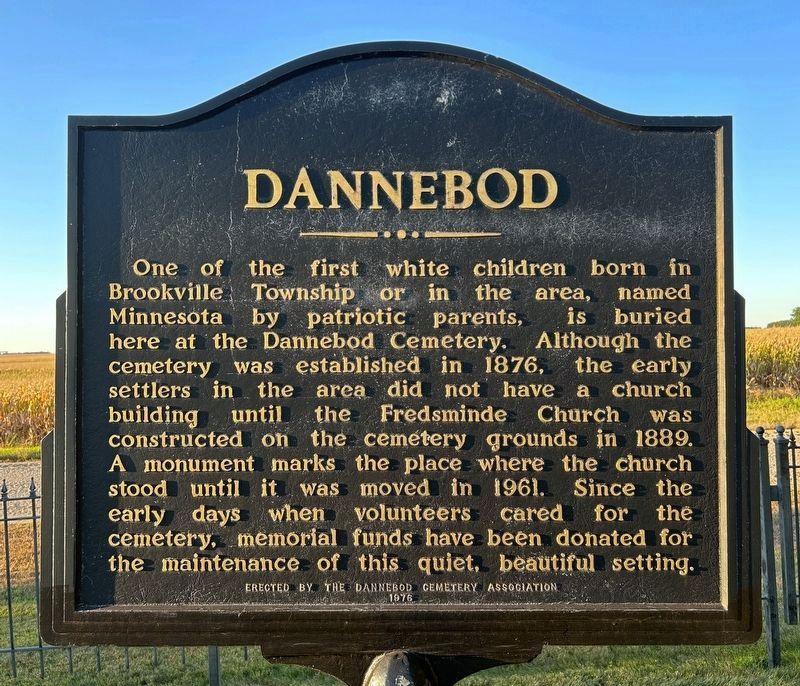
September 22, 2024
1. Dannebod Marker
Erected 1976 by the Dannebod Cemetery Association.
Topics. This historical marker is listed in these topic lists: Cemeteries & Burial Sites • Settlements & Settlers. A significant historical year for this entry is 1876.
Location. 44° 18.669′ N, 94° 53.424′ W. Marker is near Cobden, Minnesota, in Redwood County. It is in Brookville Township. It is on 180th Street 0.2 miles west of Skyview Avenue, on the right when traveling east. Located in Dannebod Cemetery. Touch for map. Marker is at or near this postal address: 44822 180th St, Sleepy Eye MN 56085, United
this page online

Regionally, this marker is in Southwest Minnesota and specifically in the Minnesota River Valley. It is also in the American Midwest, in the Corn Belt, and on the Great Plains. Globally, it is in North America, the Western Hemisphere, the Western World, and the Anglosphere. Historically, it finds itself in what was once Rupert’s Land, the territory of the Mississippian Culture, and the Louisiana Purchase.
Other nearby markers. At least 8 other markers are within 7 miles of this marker, measured as the crow flies: Fredsminde Lutheran Church (within shouting distance of this marker); Cobden (approx. 2.7 miles away); Evan (approx. 3.8 miles away); Jonathan Brown and the Shetek Trail (approx. 5.8 miles away); Springfield, Minnesota (approx. 6 miles away); Veterans Memorial (approx. 6½ miles away); a different marker also named Veterans Memorial (approx. 6½ miles away); The Attack on the Brown Family (approx. 7.1 miles away). Touch for a list and map of all markers in Cobden.
Related marker. Click here for another marker that is related to this marker.

September 22, 2024
2. Dannebod Marker & Cemetery
The Fredsminde Church monument can be seen back behind the marker.

September 22, 2024
3. Dannebod Marker, from the west

September 22, 2024
4. Dannebod Marker, from the east
Credits. This page was last revised on September 27, 2024. It was originally submitted on September 27, 2024. This page has been viewed 297 times since then and 47 times this year. Photos: 1, 2, 3, 4. submitted on September 27, 2024.
