Searsport in Waldo County, Maine — The American Northeast (New England)
Sears Island
Changing with the Times

Photographed by Steve Stoessel, September 27, 2024
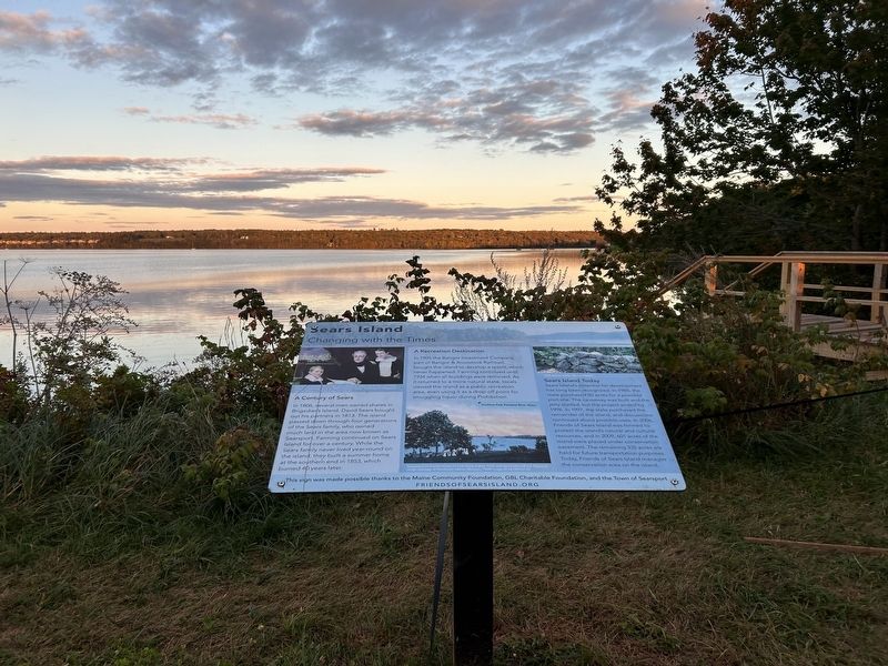
1. Sears Island Marker
A Century of Sears
In 1806, several men owned shares in Brigadier's Island. David Sears bought out his partners in 1813. The island passed down through four generations of the Sears family, who owned much land in the area now known as Searsport. Farming continued on Sears Island for over a century. While the Sears family never lived year-round on the island, they built a summer home at the southern end in 1853, which burned 40 years later.
A Recreation Destination
In 1905 the Bangor Investment Company, part of Bangor & Aroostook Railroad, bought the island to develop a resort, which never happened. Farming continued until 1934 when all buildings were removed. As it returned to a more natural state, locals viewed the island as a public recreation area, even using it as a drop-off point for smuggling liquor during Prohibition.
David Sears (1781, 1871) with sons David (b.1822) and Fredric (b. 1824). Detail of painting done in 1840, unknown artist.
Penobscot Park once stood on land along Kidder Point and Sears Island Road.
Old stone wall. Sears Island
Sears Island Today
Sears Island's potential
this page online
This sign was made possible thanks to the Maine Community Foundation, GBL Charitable Foundation, and the Town of Searsport
Erected by Friends of Sears Island.
Topics. This historical marker is listed in these topic lists: Parks & Recreational Areas • Settlements & Settlers. A significant historical year for this entry is 1800.
Location. 44° 27.376′ N, 68° 52.914′ W. Marker is in Searsport, Maine, in Waldo County. It is on Sears Island Road one mile south of U.S. 1, on the left when traveling south. Touch for map.
Photographed by Steve Stoessel, September 27, 2024
2. Sears Island Marker

Regionally, this marker is in Midcoast Maine and on Penobscot Bay. It is also in the American Northeast, in New England, and on the Eastern Seaboard. Globally, it is in the North Atlantic Region, North America, the Western Hemisphere, the Western World, and the Anglosphere.
Other nearby markers. At least 8 other markers are within 2 miles of this marker, measured as the crow flies: Brigadier’s Island (here, next to this marker); Wassumkeag (here, next to this marker); Honoring Robert and Marietta Ramsdell (a few steps from this marker); Marlboro Packard (approx. 1.4 miles away); The Home of a Hero / La maison d'un héros (approx. 1.6 miles away); The Growth of Ship Building: Isaac Carver / Le développement des chantiers navals : Isaac Carver (approx. 2 miles away); Carver Memorial Library / La Bibliothèque Carver (approx. 2 miles away); First Day at Central School: Circa 1900 / Premier jour d'école : Central school ca. 1900 (approx. 2 miles away). Touch for a list and map of all markers in Searsport.
Also see . . . Sears Island (Wikipedia).

Photographed by Steve Stoessel, September 27, 2024
3. Sears Island Marker
The marker on the right is the sears Island marker.
Credits. This page was last revised on September 29, 2024. It was originally submitted on September 27, 2024, by Steve Stoessel of Niskayuna, New York. This page has been viewed 336 times since then and 37 times this year. Photos: 1. submitted on September 27, 2024, by Steve Stoessel of Niskayuna, New York. 2, 3. submitted on September 29, 2024, by Steve Stoessel of Niskayuna, New York.
