Searsport in Waldo County, Maine — The American Northeast (New England)
Wassumkeag
A Navigation Beacon for Native Americans
Photographed by Steve Stoessel, September 27, 2024
1. Wassumkeag Marker
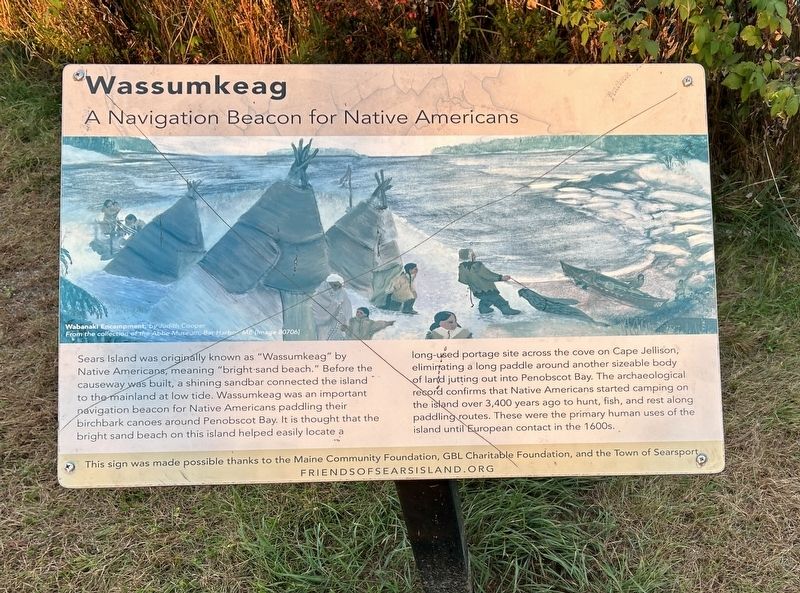
Wabanaki Encampment by Judith Cooper
Sears Island was originally known as "Wassumkeag" by Native Americans, meaning "bright sand beach." Before the causeway was built, a shining sandbar connected the island to the mainland at low tide. Wassumkeag was an important navigation beacon for Native Americans paddling their birchbark canoes around Penobscot Bay. It is thought that the bright sand beach on this island helped easily locate a long-used portage site across the cove on Cape Jellison, eliminating a long paddle around another sizeable body of land jutting out into Penobscot Bay. The archaeological record confirms that Native Americans started camping on the island over 3,400 years ago to hunt, fish, and rest along paddling routes. These were the primary human uses of the island until European contact in the 1600s.
This sign was made possible thanks to the Maine Community Foundation, GBL Charitable Foundation, and the Town of Searsport.
Erected by Friends of Sears Island.
Topics. This historical marker is listed in this topic list: Indigenous Peoples and Communities.
Location. 44° 27.379′ N,
this page online

Regionally, this marker is in Midcoast Maine and on Penobscot Bay. It is also in the American Northeast, in New England, and on the Eastern Seaboard. Globally, it is in the North Atlantic Region, North America, the Western Hemisphere, the Western World, and the Anglosphere.
Other nearby markers. At least 8 other markers are within 2 miles of this marker, measured as the crow flies: Brigadier’s Island (here, next to this marker); Sears Island (here, next to this marker); Honoring Robert and Marietta Ramsdell (a few steps from this marker); Marlboro Packard (approx. 1.4 miles away); The Home of a Hero / La maison d'un héros (approx. 1.6 miles away); The Growth of Ship Building: Isaac Carver / Le développement des chantiers navals : Isaac Carver (approx. 2 miles away); Carver Memorial Library / La Bibliothèque Carver (approx. 2 miles away);
Photographed by Steve Stoessel, September 27, 2024
2. Wassumkeag Marker
Photographed by Steve Stoessel, September 27, 2024
3. Wassumkeag Marker
Credits. This page was last revised on September 30, 2024. It was originally submitted on September 29, 2024, by Steve Stoessel of Niskayuna, New York. This page has been viewed 215 times since then and 19 times this year. Photos: 1, 2, 3. submitted on September 29, 2024, by Steve Stoessel of Niskayuna, New York.
