Dyea in Skagway in Skagway Borough, Alaska — Northwest (North America)
Ho, for the Klondike!
Photographed by William Fischer, Jr., August 24, 2024
1. Ho, for the Klondike! Marker
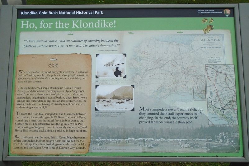
"There ain't no choice,' said an oldtimer of choosing between the Chilkoot and the White Pass. 'One's hell. The other's damnation.'"
—Martha Ferguson McKeown
Most stampeders never became rich, but they counted their trail experiences as life changing. In the end, the journey itself proved far more valuable than gold.
When news of an extraordinary gold discovery in Canada's Yukon Territory reached the public in 1897, people across the globe raced to the Klondike hoping to become rich beyond their wildest dreams.
Thousands boarded ships, steamed up Alaska's Inside Passage, and disembarked at Skagway or Dyea. Skagway's waterfront was a chaotic scene of pitched tents, shouting stampeders, neighing horses, and barking dogs. Streets were quickly laid out and buildings and wharves constructed; the town even boasted of having electricity, telephone service, and running water in 1898.
To reach the Klondike, stampeders had to choose between two routes. One was the 33-mile Chilkoot Trail out of Dyea containing a torturous thousand-foot climb known as the Golden Stairs. The alternative was the 45-mile White Pass Trail, starting
this page online
Both trails met near Bennett, British Columbia, where many of the stampeders built or bought boats and waited for the ice to break up. They then floated 550 miles through the lake systems and the Yukon River to reach Dawson City, Canada.
[Photo captions, top to bottom, read]
• View of the Golden Stairs and Scales along the Chilkoot Trail.
• The White Pass Trail, littered with dead and dying animals, soon became known as the Dead Horse Trail, 1898.
• Skagway waterfront, 1897.
[Background map reads] Map of Alaska, showing routes to the gold fields.
Erected by National Park Service.
Topics. This historical marker is listed in these topic lists: Animals • Immigration • Industry & Commerce. A significant historical year for this entry is 1897.
Location. 59° 26.951′ N, 135° 19.128′ W. Marker is in Skagway, Alaska, in Skagway Borough. It is in Dyea. It is on Congress Way, on the right when traveling south. Marker is adjacent southeast of the Skagway Small Boat Harbor. Touch for map. Marker is at or near this postal
Photographed by William Fischer, Jr., August 24, 2024
2. Ho, for the Klondike! Marker

Regionally, this marker is on the American Pacific Coast. Globally, it is in North America, on the Ring of Fire, on the Pacific Rim, in the Western Hemisphere, in the Western World, and in the Anglosphere. Historically, it finds itself in what was once the Russian Empire.
Other nearby markers. At least 8 other markers are within walking distance of this marker: Gateway to the Interior (here, next to this marker); The Road to Gold (here, next to this marker); U.S. Army Invades Skagway (here, next to this marker); Captain William Moore (approx. 0.2 miles away); Skagway's Historic Waterfront (approx. 0.2 miles away); Skagway's Shifting Shoreline (approx. 0.2 miles away); Welcome to Pullen Creek (approx. 0.2 miles away); Nature Always Succeeds! (approx. 0.2 miles away). Touch for a list and map of all markers in Skagway.
Related marker. Click here for another marker that is related to this marker.
Also see . . . Klondike Gold Rush National Historical Park. (Submitted on September 30, 2024, by William Fischer, Jr. of Reynoldsburg, Ohio.)
Credits. This page was last revised on October 1, 2024. It was originally submitted on September 30, 2024, by William Fischer, Jr. of Reynoldsburg, Ohio. This page has been viewed 187 times since then and 32 times this year. Photos: 1, 2. submitted on September 30, 2024, by William Fischer, Jr. of Reynoldsburg, Ohio.
