Baltimore Hundred in South Bethany in Sussex County, Delaware — The American Northeast (Mid-Atlantic)
The Evolution of Paradise Shores & York Beach
Photographed by Devry Becker Jones (CC0), October 5, 2024
1. The Evolution of Paradise Shores & York Beach Marker
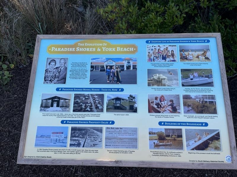
The photo on the left are of Vance and Pearl McCabe, who built York Beach Mall and developed Paradise Shores.
The photo on the right are of descendants of Vance and Pearl McCabe: Rebecca Grimes Mais (granddaughter), Sandra McCabe Robertson (daughter), and Kimberly McCabe Grimes (granddaughter) pictured in front of York Beach Mall in 2024.
The same house in 2024.
Sample of deed illustrating sale of Paradise Shores property for $13,000 in 1976.
this page online
Two original owners and a friend enjoying a day at the beach.
Wonder Woman (Lynda Carter) flying to her home on S. Ocean Drive.
Families, like the Olivers, were attracted to Paradise Shores due to convenience of parking one's boat at the homeowner's back door.
Children enjoyed taking boats out and exploring the canals of Paradise Shores.
Karyn Iacangelo, as a young girl, and friends feeding ducks who were frequent backyard visitors.
Beginning of the process to build the bulkheads.
Erected 2024 by South Bethany Historical Society.
Topics. This historical marker is listed in these topic lists: Industry & Commerce • Settlements & Settlers • Waterways & Vessels. A significant historical year for this entry is 1964.
Location. 38° 30.547′ N, 75° 3.297′ W. Marker is in South Bethany, Delaware, in Sussex County. It is in Baltimore Hundred.
Photographed by Devry Becker Jones (CC0), October 5, 2024
2. The Evolution of Paradise Shores & York Beach Marker

Regionally, this marker is on Delaware’s Beaches. It is also in the American Mid-Atlantic, on the Delmarva Peninsula, and on the Eastern Seaboard. Globally, it is in the North Atlantic Region, North America, the Western Hemisphere, the Western World, and the Anglosphere. Historically, it finds itself in what was once New Netherland, one of the original Thirteen Colonies, and the Antebellum South.
Other nearby markers. At least 8 other markers are within 2 miles of this marker, measured as the crow flies: From Farmland and Forest to Fabulous Resort Area (here, next to this marker); Key Dates and Events in the Town's History (approx. 0.9 miles away); South Bethany's Historic Roots (approx. 0.9 miles away); Life in South Bethany Through the Years (approx. 0.9 miles away); South Bethany's Local Government Evolves Over the Years (approx. 0.9 miles away); South Bethany in the 21st Century (approx. 0.9 miles away); Townsend House (approx. 1.9 miles away); Scott House (approx. 1.9 miles away). Touch for a list and map of all markers in South Bethany.
Credits. This page was last revised on June 25, 2026. It was originally submitted on October 6, 2024, by Devry Becker Jones of Washington, District of Columbia. This page has been viewed 298 times since then and 57 times this year. Photos: 1, 2. submitted on October 6, 2024, by Devry Becker Jones of Washington, District of Columbia.
Editor’s want-list for this marker. A wide shot of the marker without glare. • Can you help?
