Baltimore Hundred in South Bethany in Sussex County, Delaware — The American Northeast (Mid-Atlantic)
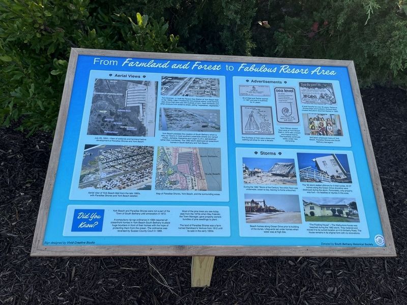
From Farmland and Forest to Fabulous Resort Area
Photographed by Devry Becker Jones (CC0), October 5, 2024
1. From Farmland and Forest to Fabulous Resort Area Marker
Tom Hickman, Jr. built the Texaco Gas Station at York Beach Mall in the 1960s. Later it hosted the first produce stand. Local farmers also drove their pick-ups with bushels of corn, fresh tomatoes and other produce from street to street, yelling "vegetables, vegetables."
York Beach predates the creation of South Bethany which is why our Town's 4 most southern oceanside streets are named Indian, Jamaica, Kewanne and Logan (I,J,K,L alphabetical) rather than numbered. The 1962 storm destroyed all oceanfront homes in South Bethany and York Beach.
Map of Paradise Shores, York Beach, and the surrounding areas.
Did You Know?
York Beach and Paradise Shores were not a part of the Town of South Bethany until annexation in 1972.
A compulsory ordinance in 1984 required all oceanfront homes in York Beach-South Bethany to place huge boulders in front of their homes with the hope of protecting them from the ocean.
this page online
Most of the pine trees you see today date from the 1970s when May Felerski, the Town Manager, gave property owners bundles of pine seedlings to plant.
The land of Paradise Shores was a farm named Derickson's Venture from 1812 until its sale in the early 1950s
The Dutchess of York was a dress and bathing suit shop for over a decade.
Tami Oltman started Sea Level at York Beach Mall in 1979 with a beach and tropical theme. The business continues today under new ownership.
A local favorite for over 35 years, Rebecca Grimes Mais and husband, Richard Mais, created McCabe's Gourmet Market in 1986.
McCabe's employed many of York Beach, Paradise Shores and South Bethany teenagers.
Beach homes along Ocean Drive prior to building of the dunes. Lifeguards sat under homes when water was at high tide.
The '62 storm stalled offshore for five tidal cycles.
Photographed by Devry Becker Jones (CC0), October 5, 2024
2. From Farmland and Forest to Fabulous Resort Area Marker
"The Floating House" — The Walburtons house was beached during the 1962 storm. The trailered and moved it to its current location at 413 Kimberly Road. The house remains in its original form with no renovations.
Erected 2024 by South Bethany Historical Society.
Topics. This historical marker is listed in these topic lists: Disasters • Industry & Commerce • Settlements & Settlers • Waterways & Vessels. A significant historical date for this entry is July 20, 1954.
Location. 38° 30.55′ N, 75° 3.297′ W. Marker is in South Bethany, Delaware, in Sussex County. It is in Baltimore Hundred. It is at the intersection of York Road and Coastal Highway (Delaware Route 1), on the right when traveling east on York Road. Touch for map. Marker is at or near this postal address: 34459 Coastal Hwy, Bethany Beach DE 19930, United States of America. Touch for directions.

Regionally, this marker is on Delaware’s Beaches. It is also in the American Mid-Atlantic, on the Delmarva Peninsula, and on the Eastern Seaboard. Globally, it is in the North Atlantic Region, North America, the Western Hemisphere, the Western World, and the Anglosphere. Historically, it finds itself in what was once New Netherland, one of the original Thirteen Colonies, and the Antebellum South.
Other nearby markers. At least 8 other markers are within 2 miles of this marker, measured as the crow flies: The Evolution of Paradise Shores & York Beach (here, next to this marker); Key Dates and Events in the Town's History (approx. 0.9 miles away); South Bethany's Historic Roots (approx. 0.9 miles away); Life in South Bethany Through the Years (approx. 0.9 miles away); South Bethany's Local Government Evolves Over the Years (approx. 0.9 miles away); South Bethany in the 21st Century (approx. 0.9 miles away); Townsend House (approx. 1.9 miles away); Scott House (approx. 1.9 miles away). Touch for a list and map of all markers in South Bethany.
Credits. This page was last revised on June 25, 2026. It was originally submitted on October 6, 2024, by Devry Becker Jones of Washington, District of Columbia. This page has been viewed 143 times since then and 16 times this year. Photos: 1, 2. submitted on October 6, 2024, by Devry Becker Jones of Washington, District of Columbia.
