Pigeon Forge in Sevier County, Tennessee — The American South (East South Central)
Fort Wear
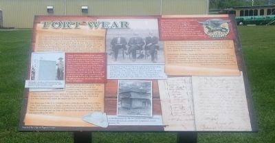
Photographed by Marcia Nelson, June 12, 2013
1. Fort Wear Marker
Col. Samuel Wear built Fort Wear in this vicinity about 1781, the year that Cornwallis surrendered at Yorktown. Fort Wear was one of nearly a dozen forts built in the 1780s in Sevier County. Its blockhouse was made from sturdy hand-hewn logs and was still a refuge in 1793. The fort was on a branch of the Great Indian War Path, which was also a trading route from Virginia to the Cherokee towns on the Little Tennessee River. This site, once surrounded by buffalo and other wild game, was in the wilderness western territory of North Carolina, one of the thirteen original colonies.
Some of the first settlers from western North Carolina had received land grants from their home state before Tennessee was formed. When Wear settled here, the U.S. Government and the Cherokee people considered this area to be Indian hunting grounds. However, there were pioneers who believed that the Native Americans had relinquished their right of ownership by aligning themselves with Great Britain in the war. This conflict led to fighting between the whites and the Native Americans.
North Carolina, not yet a state, unsuccessfully attempted
this page online
Fort Wear was in the U.S. Territory South of the River Ohio from 1790 to 1796, until Tennessee was finally admitted to the Union on June 1, 1796. The fort was a haven for soldiers and settlers as North Carolina, the United States Government and the State of Franklin made treaties with the Indians, one superseding the other.
Samuel Wear was a patriot who fought for the American Colonies before the Revolution. During the American Revolution, he stood with Col. John Sevier at the Battle of Kings Mountain in1780. He defended settlers during the Indian Campaigns and was commissioned a colonel prior to fighting in the War of 1812. He served in the Sevier County and East Tennessee Militias.
Col. Wear was a leader in the formation of county, territorial, State of Franklin and Tennessee governments. He served as representative to the territorial
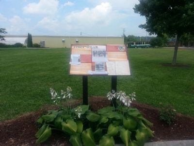
Photographed by Marcia Nelson, June 12, 2013
2. Fort Wear Marker
Samuel Cole Williams, Associate Justice of the Tennessee Supreme Court, said: “Wear was a man of much force of character, brave in battle and wise in council.” His participation in territorial government and in Tennessee’s formation gives Col. Wear a prominent place in Tennessee history. (Below) Tennessee Constitution Preamble and Signatures – 1796 Photos below by Tennessee Library & Archives
(captions)
Richard L. Kelton, a Wear descendent, stands by the Colonel’s monument, dedicated in 1925, located nearby. Col. Samuel Wear (1753-1817) brought his family here from Augusta County, Virginia. His son Robert Wear, born November 4, 1781, was likely the first white child born in this area. Col. Wear’s brother John, a soldier, marched to Wear’s Fort in early 1782. (Above:) Three of Col. Samuel Wear’s grandsons, from left to right: Jefferson, John and Lavater Wear.
(Left) Illustration by Phyllis Hatcher Sims. (Above) Fort Marr Blockhouse, pictured for comparison, is near Benton, TN.
Erected 2013 by City of Pigeon Forge.
Topics. This historical marker is listed in these topic lists: Forts and Castles • Indigenous Peoples and Communities • Settlements & Settlers • War, US Revolutionary. A significant historical month for this entry is June 1890.
Location. 35° 48.405′ N, 83° 35.006′ W. Marker is in Pigeon Forge, Tennessee, in Sevier County. It is on Library Drive 0.2 miles north of Community Center Drive, on the right when traveling west. Located on the Fort Wear Cemetery perimeter east of the Pigeon Forge City Park / tennis courts parking lot behind the public library. Touch for map. Marker is at or near this postal address: 2449 Library Drive, Pigeon Forge TN 37863, United States of America. Touch for directions.

Regionally, this marker is in East Tennessee and in the Great Smoky Mountains. It is also in the American South, specifically in the Upper South, in Appalachia, and specifically in Southern Appalachia. Globally, it is in North America, the Western Hemisphere, the Western World, and the Anglosphere. Historically, it finds itself in what was once the original Cherokee Nation, the territory of the Mississippian Culture, one of the Confederate States of America, the State of Franklin, and the Antebellum South.
Other nearby markers. At least 8 other markers are within 2 miles of this marker, measured as the crow flies: Colonel Samuel Wear Memorial (within shouting distance of this marker); Wear's Fort (approx. 0.3 miles away); Henderson Springs Resort (approx. 0.4 miles away); Shiloh Church (approx. 0.6 miles away); a different marker also named Shiloh Church (approx. 0.6 miles away); Pine Grove Rural Community (approx. 0.7 miles away); Titanic’s Center Anchor (approx. one mile away); Early Pigeon Forge (approx. 2 miles away). Touch for a list and map of all markers in Pigeon Forge.
Another marker is no longer nearby. Titanic Eternal Flame (was approx. one mile away but has been permanently removed).
Credits. This page was last revised on October 9, 2024. It was originally submitted on June 13, 2013, by Marcia Nelson of Pigeon Forge, Tennessee. This page has been viewed 2,477 times since then and 101 times this year. Last updated on October 8, 2024, by Marcia Nelson of Pigeon Forge, Tennessee. Photos: 1, 2. submitted on June 13, 2013, by Marcia Nelson of Pigeon Forge, Tennessee. • Devry Becker Jones was the editor who published this page.
