Elkin in Surry County, North Carolina — The American South (South Atlantic)
David Allen's Iron Works

Photographed by Mark Parker, October 12, 2024
1. David Allen's Iron Works Marker
David Allen, Eighteenth-Century Entrepreneur
David Allen arrived mid-century in the foothills of the Blue Ridge Mountains. With an eye on the plentiful timber and swiftly moving rivers, he set about building a sawmill. He likely had lumber mill experience to use in establishing his new business and was willing to take a few calculated risks. The time was ripe to build new frontier communities, and he found steady customers in the Moravian settlements to the east.
The Moravians, or the Unitas Fratrum, were a religious group originating fom eastern Germany and Czech lands of central Europe. Upon migrating to North Carolina, they founded Bethania, Bethabara, and Salem in present-day Forsyth County. They kept meticulous records as their settlements grew. Their accounts show that they purchased pine boards from Allen in 1768 and 1769 for new construction.
With cash coming in, Alen was able to purchase land as soon as the state land office opened in 1777. By 1782 he had acquired 2,482`acres on adjoining tracts in southwest Surry County and eastern Wilkes County.
Producing Wrought Iron
Iron was removed from natural
this page online
Allen's workers transported rocks containing iron to the bloomery site, broke them into manageable sizes and heated them to remove moisture. The rocks were then crushed by hand or by water-powered hammers. This area along the Yadkin River, once referred to as "Allen's Settlement", was easily able to supply the tremendous amount of wood needed to heat the furnace.
Photographed by Mark Parker, October 12, 2024
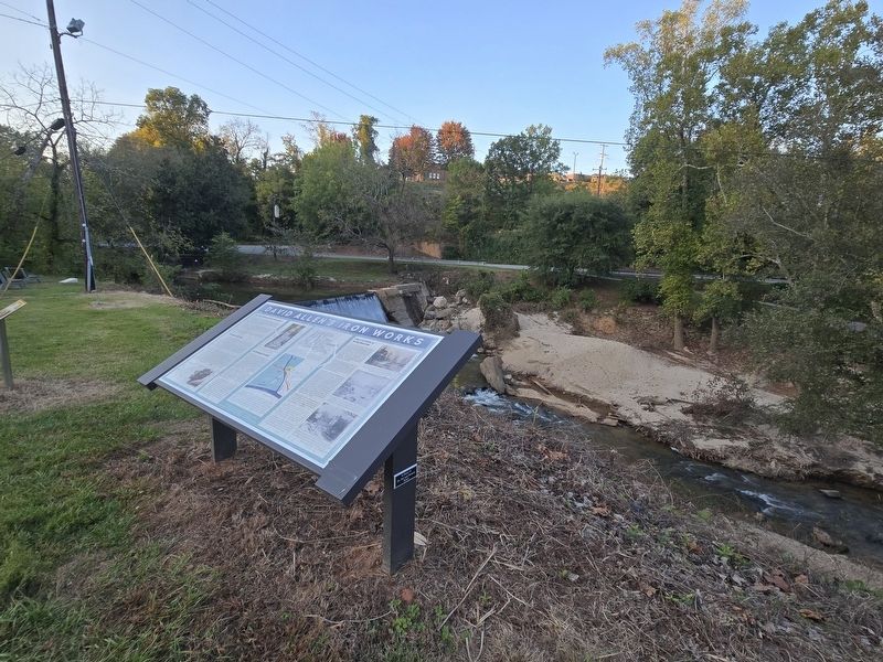
2. David Allen's Iron Works Marker overlooking the dam and Big Elkin Creek
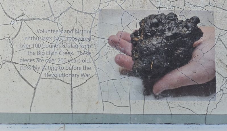
(captions) Volunteers and history enthusiasts have recovered over 100-pounds of slag from the Big Elkin Creek. These pieces are over 200 years old, possibly dating to before the Revolutionary War.
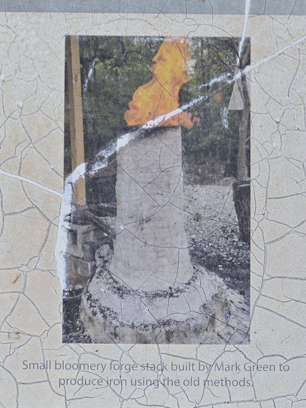
Small bloomery forge stack built by Mark Green to produce iron using the old methods.
An Exceptional Location
David Allen sold all of his property and interest in iron production to William Hill in 1786. Then during the next two to three decades the Big Elkin forge was managed by Hill Jonathan Haines, and a Mr. Martin. Maps dated 1798 and 1808 label the site as the Martin Iron Works. Surry County
Photographed by Mark Parker, October 12, 2024
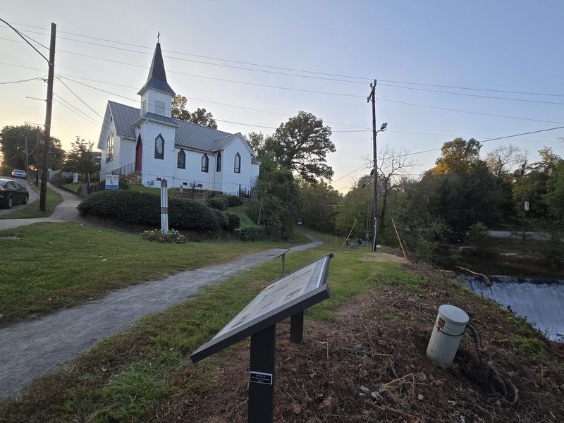
3. David Allen's Iron Works Marker along the Overmountain Victory Trail north of West Main St
Galloway Memorial Episcopal Church is in the background
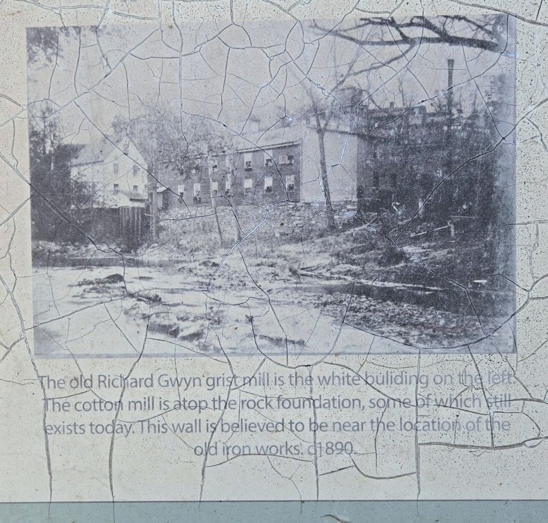
The next record referring to the forge was in 1830 when William Green mortgaged 367 acres "which was part of the old iron works site." Finally, in 1839 Richard Gwyn purchased the old iron works tract and built a grist mill with a dam on the site-in 1840, followed by a cotton mill in 1847, leading to the Elkin Mfg. Company and eventually Chatham Mfg. Company.
Iron works in the area went out of business for a number of reasons: increased settlements reducing the supply of timber, competition from more efficient, sophisticated forges using hotter fuel built elsewhere; or new residents who worked in farming and animal husbandry for income. But what is known is that later entrepreneurs saw the same excellence in the location, as did David Allen: choice land at a small, deep river with plentiful drop in elevation
Photographed by Mark Parker, October 12, 2024
4. A sample of slag collected from Big Elkin Creek
Some slag collection are believed to date back to the Revolutionary War.
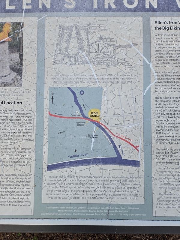
(caption) Large forge operation. Ransom, James Maxwell. Vanishing Iron Works of the Rampos: The story of the Forges Furnaces, and Mines of the New Jersey-New York Border Area. New Brunswick Rutgers University Press, 1966
Through careful reading of land deeds and grants, researchers have been able to map Allen's land tracts and pinpoint exactly where the iron works ware located. Boundaries and landmarks in the deeds refer to a "corner birch" (1) downstream from the Allen Forge at present day West Main St and to a walnut (2) on the creek's west bank at the forge dam near the present-day Market St. bridge. This is the same location of a later dam that powered Richard Gwyn's mills. The forge was on the east creek bank (3), just north of the present Elkin Public Library.
Allen's Iron Works on the Big Elkin Creek
In 1750 Great Britain forbade the manufacture of many iron products in the American colonies, forcing the colonists to purchase them from England and pay tariffs on these
Photographed by Mark Parker, October 12, 2024
5. Bloomery forge stack
David Allen was positioned to take advantage of the offer. He already owned plenty of timber to fuel a furnace, he employed workers and built a dam providing power, roads had been established to his sawmill, and river transportation was right outside his door. All he had to do was look about for evidence of iron ore on his land and start excavating it.
Roads leading to the forge were often referred to as the "Iron Works Road" as early as 1778. Proceeding north from the forge, the road (later Elk Spur St.) forded the creek and ran toward Longbottom (present-day Traphill); south from the forge, the road (present-day Front St.) headed toward the Yadkin River. This would have been a principal route for transporting wrought iron to customers south and east.
Photographed by Mark Parker, October 12, 2024
6. (top) Large forge operation/ (bottom) map showing former locations of iron works
The date for the end of the iron works operation is not known, but the last iron bars were produced some time after 1802 and well before 1830, The November 26, 1922 issue of the Winston-Salem Journal referred to the old iron works on Elkin Creek:
A small dam was built across the creek to furnish a sufficient supply of water to run the forge. Every time the creek got up three or four feet, the dam would be swept out. A man named Hanes was the manager of the forge and, becoming worried with the washouts, employed a lot of laborers and built a dam on a rock foundation, drilling deep holes into the rock and inserting iron bars and rock and mortar.
They finished the dam on Saturday and Hanes boasted that God, man nor devil himself couldn't move it. That night a cloudburst on the creek above and next day the only sign the dam that was left were some of the holes in the rock where the iron bars had been. This was of the end of the iron forge.
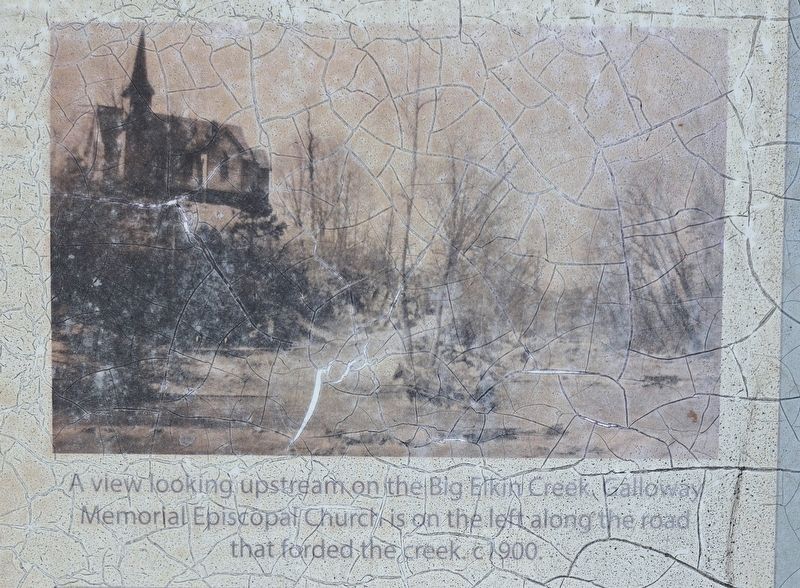
(captions) A view-looking upstream on the Big Elkin Creek. Gallaway Memorial Episcopal Church is on the left along the road that forded the creek. c.1900
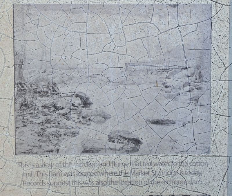
This is a view of the old dam and flume that fed water to the cotton mill. This dam was located where the Market St. bridge is today. Records suggest this was also the location of the old forge dam.
The old Richard Gwyn grist mill is the white building on the left. The cotton mill is atop the rock foundation, some of which exists today. This wall is believed to be near the location of the old iron works. c. 1890
Topics.
Photographed by Mark Parker, October 12, 2024
7. Richard Gwyn Grist Mill
The old Richard Gwyn grist mill is the white buliding on the cotton mill is atop the rock founplation, some of whích exists today. This wall is believed to be near the location of the old iron works. c. 1890
Location. 36° 14.626′ N, 80° 51.314′ W. Marker is in Elkin, North Carolina, in Surry County. It can be reached from the intersection of West Main Street and Terrace Avenue, on the right when traveling west. The marker is along the Overmountain Victory National Trail branching north from West Main Street along Big Elkin Creek. The marker is close to Galloway Memorial Episcopal Church. Touch for map. Marker is at or near this postal address: 308 W Main St, Elkin NC 28621, United States of America. Touch for directions.

Regionally, this marker is in the Piedmont. It is also in the American South, specifically in the Upper South, in Appalachia, and specifically in Southern Appalachia. Globally, it is in North America, the Western Hemisphere, the Western World, and the Anglosphere. Historically, it finds itself in what was once the territory of the Mississippian Culture, one of the original Thirteen Colonies, one of the Confederate
Photographed by Mark Parker, October 12, 2024
8. Galloway Memorial Episcopal Church
A view looking upstream ọn the|Big Elkin Creek Galloway Memorial Episcopal Church is on the left along the road that forded the creek c. 1900.
Other nearby markers. At least 8 other markers are within walking distance of this marker: Elkin Manufacturing Company (here, next to this marker); Elkin & Alleghany Railway by the 1910 Dam (within shouting distance of this marker); a different marker also named Elkin Manufacturing Company (about 400 feet away, measured in a direct line); First Dam on the Elkin Creek (about 400 feet away); Elkin & Alleghany Engine 100 (about 400 feet away); Elkin & Alleghany Railroad Depot (about 500 feet away); Elkin & Alleghany Railway Depot (about 500 feet away); Boone Trail Highway (approx. ¼ mile away). Touch for a list and map of all markers in Elkin.
Photographed by Mark Parker, October 12, 2024
9. Old dam and flume
This is a view of the old dam and flume that fed water to the cotton mill. This dam was located where the Market St. bridge is today. Records suggest this was also the location of the old forge dam.
Credits. This page was last revised on October 15, 2024. It was originally submitted on October 12, 2024, by Mark Parker of Hickory, North Carolina. This page has been viewed 845 times since then and 173 times this year. Last updated on October 14, 2024, by Mark Parker of Hickory, North Carolina. Photos: 1. submitted on October 12, 2024, by Mark Parker of Hickory, North Carolina. 2, 3, 4, 5, 6. submitted on October 13, 2024, by Mark Parker of Hickory, North Carolina. 7, 8, 9. submitted on October 14, 2024, by Mark Parker of Hickory, North Carolina. • Bernard Fisher was the editor who published this page.
