Thomaston in Knox County, Maine — The American Northeast (New England)
Shipbuilding in Thomaston
Photographed by Darren Jefferson Clay, October 15, 2024
1. Shipbuilding in Thomaston Marker
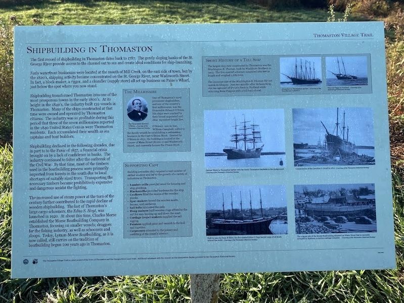
The first record of shipbuilding in Thomaston dates back to 1787. The gently sloping banks of the St. George River provide access to the channel out to sea and create ideal conditions for ship-launching.
Early waterfront businesses were located at the mouth of Mill Creek, on the east side of town, but by the 1820's, shipping activity became concentrated on the St. George River, near Wadsworth Street. In fact, a block-maker, a rigger, and a chandler (supply store) all set up business on Paine's Wharf, just below the spot where you now stand.
Shipbuilding transformed Thomaston into one of the most prosperous towns in the early 1800's. At its height in the 1840's, the industry built 139 vessels in Thomaston. Many of the ships constructed at that time were owned and operated by Thomaston citizens. The industry was so profitable during this period that three of the seven millionaires reported in the 1840 United States Census were Thomaston residents. Each accumulated their wealth as sea captains and boat builders.
Shipbuilding declined in the following decades, due in part to the Panic of 1857, a financial crisis brought
this page online
The increased use of steam power at the turn of the century further contributed to the rapid decline of wooden shipbuilding. The last of Thomaston's large cargo schooners, the Edna S. Hoyt, was launched in 1920. At about this time, Charles Morse established the Morse Boatbuilding Company in Thomaston, focusing on smaller vessels; draggers for the fishing industry, as well as schooners and sloops. Today, Lyman-Morse Boatbuilding, as it is now called, still carries on the tradition of boatbuilding begun 200 years ago in Thomaston.
The Millionaire
One of Thomaston's most prominent shipbuilders, and on of the country's first millionaires, was the Honorable Edward O'Brien. His ships were marked by their broad unpainted and clear-varnished bright line.
O'Brien's son-in-law,
Photographed by Darren Jefferson Clay, October 15, 2024
2. Shipbuilding in Thomaston Marker
Supporting Cast
Building a wooden ship required a vast number of skilled workers and led to the growth of a variety of industries in Thomaston.
Lumber mills provided wood for housing and ship planking.
Blacksmiths provided hardware for the ship.
Caulkers filled the seams of the wooden planks.
Spar-makers hewed the wooden masts, booms, and yardarms.
Sail lofts fabricated the sails.
Hoop makers built wooden rings affixed to the sail for easy hauling up and down the mast.
Cordage (rope) makers supplied the sail rigging.
Painters applied paint and varnish to the hull and topsides
Carpenters attended to the joinery and outfitting of the vessel's interior.
Short History of a Tall Ship
The largest ship ever constructed in Thomaston was the Washington B. Thomas, built by Washburn Brothers in 1903. The five-masted schooner measured 289 feet in length and weighted 2,689 tons.
The immense size of the Washington B. Thomas did not match its lifespan. Just two months after its launching, she ran aground of Prout's Neck in Portland while returning from Virginia with a full load of coal.
Erected by Thomaston Village Trail.
Topics. This historical marker is listed in these topic lists: Industry & Commerce • Waterways & Vessels. A significant historical year for this entry is 1787.
Location. 44° 4.538′ N, 69° 11.658′ W. Marker is in Thomaston, Maine, in Knox County. It can be reached from Main Street (U.S. 1) near Ship Street, on the right when traveling east. Touch for map. Marker is at or near this postal address: 17 Ship St, Thomaston ME 04861, United States of America. Touch for directions.

Regionally, this marker is in Midcoast Maine and on Penobscot Bay. It is also in the American Northeast, in New England, and on the Eastern Seaboard. Globally, it is in the North Atlantic Region, North America, the Western Hemisphere, the Western World, and the Anglosphere.
Other nearby markers. At least 8 other markers are within walking distance of this marker: 178 Years of History / 178 Ans d'Histoire (about 800 feet away, measured in a direct line); Maine State Prison at Thomaston (about 800 feet away); Maine State Prison (approx. 0.2 miles away); Former State Prison Site (approx. 0.2 miles away); A Unique Pumper and Old Fire Houses (approx. 0.2 miles away); Near the Old Prison / À Coté de l'Ancienne Prison (approx. ¼ mile away); War Memorial (approx. 0.4 miles away); The Voyage of Captain George Waymouth (approx. 0.4 miles away). Touch for a list and map of all markers in Thomaston.
Credits. This page was last revised on July 7, 2025. It was originally submitted on October 27, 2024, by Darren Jefferson Clay of Duluth, Georgia. This page has been viewed 416 times since then and 71 times this year. Photos: 1, 2. submitted on October 27, 2024, by Darren Jefferson Clay of Duluth, Georgia. • Michael Herrick was the editor who published this page.
