Downtown in Anchorage, Alaska — Northwest (North America)
Anchorage Area Time Line

Photographed by William Fischer, Jr., August 12, 2024
1. Anchorage Area Time Line Marker
5000 B.C.
Earliest known human habitation in the Anchorage area
1756
First contact between Athabaskan Dena'ina people and European cultures. Dena'ina population in the Anchorage area estimated at 5000 people
1778
English explorer, Captain James Cook discovered and explored the Anchorage area. Cook mistook one of the inlet's arms for a river and named it "River Turnagain". It was later renamed Turnagain Arm by the explorer George Vancouver
ca 1780
Russian missionaries and trading activity extended into Cook Inlet.
1839
Dena'ina population decimated by smallpox
1867
United States purchased Alaska territory from Russia for $7,200,000
1868
Alaska Commercial Company began operating trading stations along Cook Inlet. A.C.C. was the strongest organized non-native group in the area. Commercial and civilian laws were administered by military personnel.
1880
Ivan Petroff compiled the first census of Alaska
1884
Civilian colonial government was established
1888
Gold was discovered in the Turnagain Arm area
1896
James Girdwood staked a placer claim at Crow Creek, south of Anchorage
1898
Congress extended Homesteading Act to Alaska
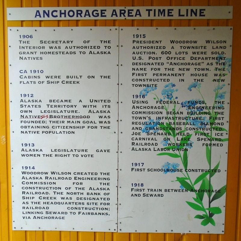
1906
The Secretary of the Interior was authorized to grant homesteads to Alaska Natives
ca 1910
Cabins were built on the flats of Ship Creek
1912
Alaska became a United States Territory with its own legislature. Alaska Native Brotherhood was founded; their main goal was obtaining citizenship for the native population
1913
Alaska legislature gave women the right to vote
1914
Woodrow Wilson created the Alaska Railroad Engineering Commission for the construction of the Alaska Railroad. The north bank of Ship Creek was designated as the headquarters site for railroad construction; linking Seward to Fairbanks, via Anchorage
1915
President Woodrow Wilson authorized
this page online
1916
Using federal funds, the Anchorage Engineering Commission began building the town's infrastructure. First regulation baseball diamond and grandstands constructed. Joe Spenard held first ice carnival on Lake Spenard. Railroad workers formed Alaska Labor Union
1917
First schoolhouse constructed
1918
First train between Anchorage and Seward
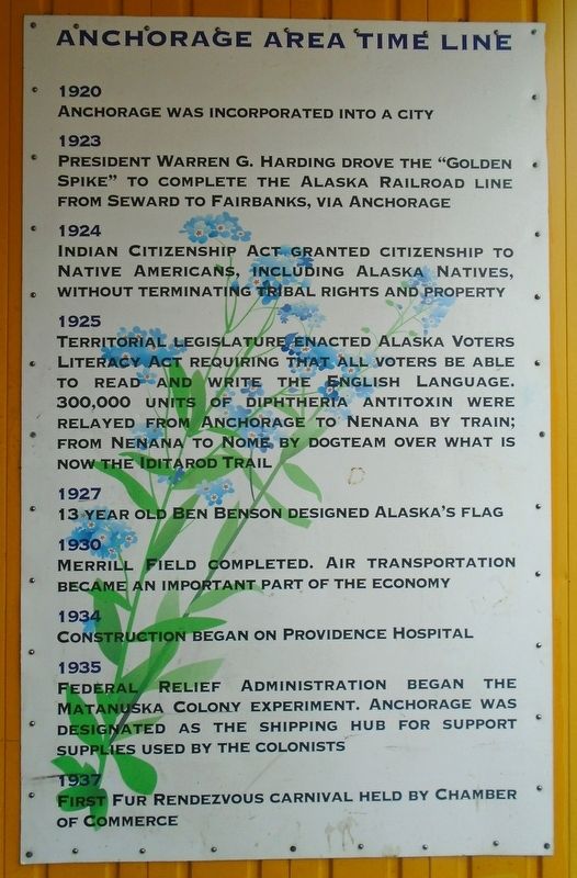
1920
Anchorage was incorporated into a city
1923
President Warren G. Harding drove the "Golden Spike” to complete the Alaska Railroad line from Seward to Fairbanks, via Anchorage
1924
Indian Citizenship Act granted citizenship to Native Americans, including Alaska Natives, without terminating tribal rights and property
1925
Territorial legislature enacted Alaska Voters Literacy Act requiring that all voters be able to read and write the English language. 300,000 units of diphtheria antitoxin were relayed from Anchorage to Nenana by train; from Nenana to Nome by dogteam over what is now the

Photographed by William Fischer, Jr., August 12, 2024
2. Anchorage Area Time Line Marker
1927
13 year old Ben Benson designed Alaska's flag
1930
Merrill Field completed. Air transportation became an important part of the economy
1934
Construction began on Providence Hospital
1935
Federal Relief Administration began the Matanuska Colony experiment. Anchorage was designated as the shipping hub for support supplies used by the colonists
1937
First fur rendezvous carnival held by Chamber of Commerce
1940
Construction began on Fort Richardson and Elmendorf [Army] Air Force Base
1942
1,523-mile Alaska Canadian Military Highway from Dawson Creek, Canada, to Fairbanks was built in 9 months. Japanese bombed Dutch Harbor on Unalaska Island and invaded Kiska and Attu Islands in the Aleutian chain. This was the only invasion of United States soil, by an enemy force during a World War
1943
American forces staged major attacks on Kiska and Attu Islands, returning them to American control
1945
February 16th was designated "Elizabeth Peratrovich Day". Elizabeth Peratrovich was a Tlingit Native Rights activist, tirelessly campaigning for equality for all Alaskans. Her campaign for caused the legislature to pass a law ending legal segregation in Alaska
1946
Alaska voted to apply for statehood
1949
First traffic lights installed on 4th Avenue
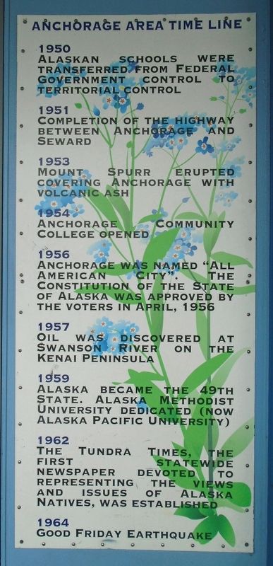
1950
Alaskan schools were transferred from Federal Government control to territorial control
1951
Completion of the highway between Anchorage and Seward
1953
Mount Spurr erupted covering Anchorage with volcanic ash
1954
Anchorage Community College opened
1956
Anchorage was named "All American City". The Constitution of the State of Alaska was approved by the voters in April, 1956
1957
Oil was discovered at Swanson River on the Kenai Peninsula
1959
Alaska became the 49th State. Alaska Methodist University dedicated (now Alaska Pacific
Photographed by William Fischer, Jr., August 12, 2024
3. Anchorage Area Time Line Marker
1962
The Tundra Times, the first statewide newspaper devoted to representing the views and issues of Alaska Natives, was established
1964
Good Friday earthquake
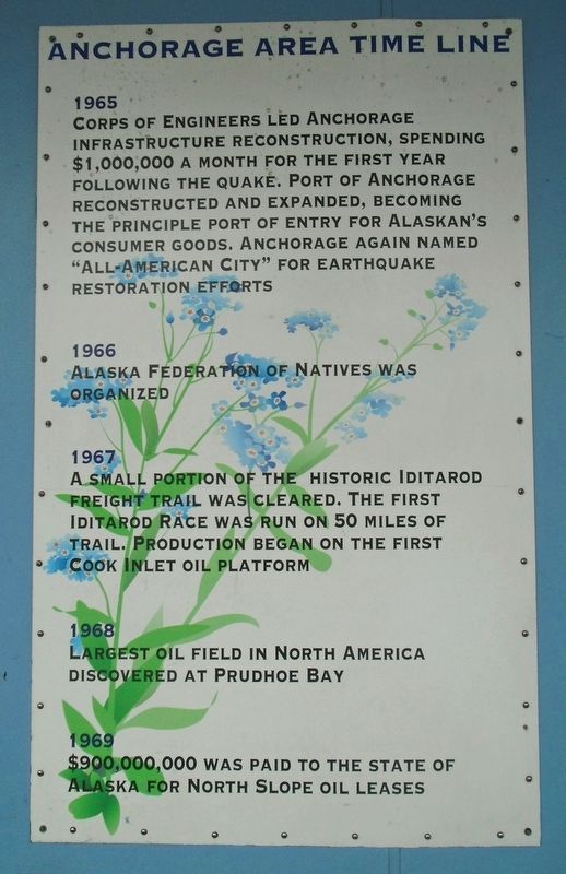
1965
Corps of Engineers led Anchorage infrastructure reconstruction, spending $1,000,000 a month for the first year following the quake. Port of Anchorage reconstructed and expanded, becoming the principle port of entry for Alaskan's consumer goods. Anchorage again named "All-American City” for earthquake restoration efforts
1966
Alaska Federation of Natives was organized
1967
A small portion of the historic Iditarod freight trail was cleared. The first Iditarod Race was run on 50 miles of trail. Production began on the first Cook Inlet oil platform
1968
Largest oil field in North America discovered at Prudhoe Bay
1969
$900,000,000 was paid to the state of Alaska for North Slope oil leases
1971
Alaska [N]ative Claims Settlement Act (ANSCA) was passed by [C]ongress. It created 12 regional for profit corporations.
1972
The [M]arine Mammal Protection Act became law with the provision that Alaska Natives would have traditional use of marine
Photographed by William Fischer, Jr., August 12, 2024
4. Anchorage Area Time Line Marker
1973
First Iditarod race from Anchorage to Nome
1974
Construction began on the Trans-Alaska pipeline system
1975
City of Anchorage and Greater Anchorage Area Borough united into Municipality of Anchorage
1976
Litigation resulted in state government providing local schools for Alaska Native communities, equal to those provided for urban communities
1976
Voters approve constitutional amendment establishing the Alaska Permanent Fund to receive "at least 25 percent" of all state oil revenues and related income.
1977
Construction on the pipeline is completed, and the first oil arrives through the pipeline in Valdez.
The Trans-Alaska Pipeline: A barrel of crude oil takes 5.04 days to flow from Prudhoe Bay to Valdez through the [T]rans-Alaska pipeline at 6.62 mph. If the pipeline were full, it would hold 9 million barrels. One barrel equals 42 gallons.
1982
Time zones shift to include all of Alaska, except western-most Aleutian Islands, in one zone: Alaska Standard Time.
The Oscar Anderson House, built in 1915, is restored and opened to public. Now located on the corner of 4th & D.
1984
Anchorage named "All-American City" for third time.
1985
State purchases Alaska Railroad from the federal government
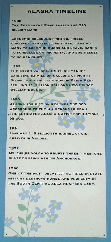
1988
The Permanent Fund passes the $10 billion mark.
Economic doldrums from oil prices continue to affect the state, causing many to lose their jobs and leave, banks to foreclose on property, and businesses to go bankrupt.
1989
The Exxon Valdez, a 987' oil tanker carrying 53 million gallons of North Slope crude oil, grounds on Bligh Reef spilling 11 million gallons into Prince William Sound.
1990
Alaska population reaches 550,000 according to the US Census Bureau[.] The estimated Alaska Native population: 95,000.
1991
January 1: 8 billionth barrel of oil arrives in Valdez.
1992
Mt. Spurr volcano

Photographed by William Fischer, Jr., August 12, 2024
5. Anchorage Area Time Line Marker
1996
One of the most devastating fires in state history destroys homes and property in the South Central area near Big Lake.
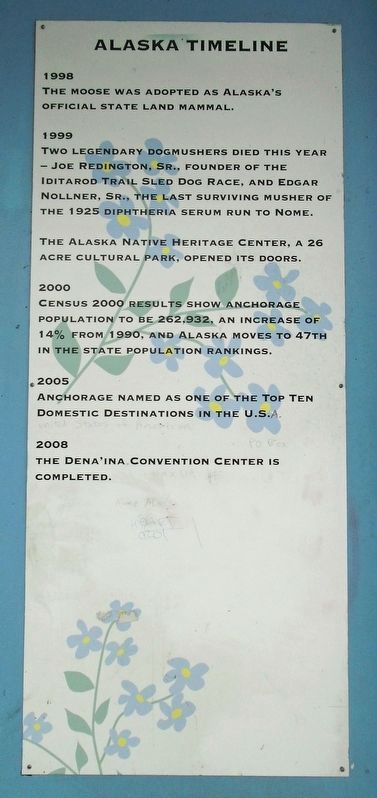
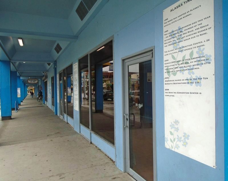
1998
The moose was adopted as Alaska's official state land mammal.
1999
Two legendary dogmushers died this year
—Joe Redington, Sr., founder of the Iditarod Trail Sled Dog Race, and Edgar Nollner, Sr., the last surviving musher of the 1925 diphtheria serum run to Nome.
The Alaska Native Heritage Center, a 26 acre cultural park, opened its doors.
2000
Census 2000 results show Anchorage population to be 262,932, an increase of 14% from 1990, and Alaska moves to 47th in the state population rankings.
2005
Anchorage named as one of the Top Ten Domestic Destinations in the U.S.
2008
The Dena'ina Convention Center is completed.
Topics. This historical marker is listed in these topic lists: Indigenous Peoples and Communities • Industry & Commerce • Settlements & Settlers • War, World II. A significant historical year for this entry is 1756.
Location. 61° 13.123′ N, 149° 53.313′ W. Marker is in Anchorage, Alaska. It is in Downtown. It is at the intersection of West 4th Avenue and D Street, on the left when traveling east on West 4th Avenue. Time Line runs west to east under the covered 4th Avenue Market Place colonnade between E and C Streets. Touch for map. Marker is at or near this postal address: 411 West 4th Avenue, Anchorage AK 99501, United States of America. Touch for directions.

Regionally, this marker is in the Alaska Railroad Corridor, in the Athabascan Region, in the Prince William Sound, and in Southcentral Alaska. It is also on the American Pacific Coast. Globally, it is in North America, on the Ring of Fire, on the Pacific Rim, in the Western Hemisphere, in the Western World, and in the Anglosphere.
Photographed by William Fischer, Jr., August 12, 2024
6. Anchorage Area Time Line Marker
Other nearby markers. At least 8 other markers are within walking distance of this marker: Anchorage Area 1940-1949 (here, next to this marker); a different marker also named Anchorage Area 1940-1949 (here, next to this marker); Anchorage Area 1950-1963 (a few steps from this marker); Bear Totem (a few steps from this marker); Anchorage Area All-American City (within shouting distance of this marker); Anchorage Area 1930-1939 (within shouting distance of this marker); Iditarod Sled Dog Race History (within shouting distance of this marker); Anchorage Area 1916-1920 (within shouting distance of this marker). Touch for a list and map of all markers in Anchorage.
Photographed by William Fischer, Jr., August 12, 2024
7. Anchorage Area Time Line Marker

Photographed by William Fischer, Jr., August 12, 2024
8. Anchorage Area Time Line Marker

Photographed by William Fischer, Jr., August 12, 2024
9. Anchorage Area Time Line Marker
Photographed by William Fischer, Jr., August 12, 2024
10. Anchorage Area Time Line Marker
Photographed by William Fischer, Jr., August 12, 2024
11. Anchorage Area Time Line Marker

Photographed by William Fischer, Jr., August 12, 2024
12. Anchorage Area Time Line Markers
Photographed by William Fischer, Jr., August 12, 2024
13. Anchorage Area Time Line Markers
Credits. This page was last revised on November 5, 2024. It was originally submitted on November 4, 2024, by William Fischer, Jr. of Reynoldsburg, Ohio. This page has been viewed 239 times since then and 44 times this year. Photos: 1, 2, 3, 4, 5, 6, 7, 8, 9, 10, 11, 12, 13. submitted on November 4, 2024, by William Fischer, Jr. of Reynoldsburg, Ohio.
