Thomaston in Knox County, Maine — The American Northeast (New England)
The Town that Went to Sea
⎯⎯⎯
"La Ville Tournée vers la mer"
Thomaston, Maine
| — | The Museum in the Streets | — |
Photographed by Darren Jefferson Clay, October 15, 2024
1. The Town that Went to Sea Marker

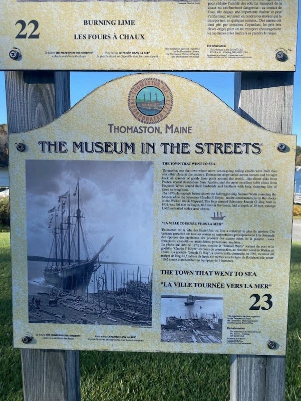
Thomaston was the town where more ocean-going sailing vessels were built than any other place in the country. Thomaston ships sailed across oceans and brought back all manner of goods from ports around the world....the finest silks from France, crystal chandeliers from Austria, and the most excellent table china from England. Wives armed their husbands and brothers with long shopping lists of items to bring back.
The 1870 photograph below shows the full rigged ship Samuel Watts rounding the beacon while the Schooner Charles F. Heyer, under construction, is on the stocks at the Walker Dunn Shipyard. The four masted Schooner Joseph G. Ray, built in 1901, was 204 feet in length, 40.3 feet in the beam, had a depth of 19 feet, tonnage 1,062 and sailed with a crew of nine.
La photo, qui date de 1870, nous montre
this page online
Erected by The Museum in the Streets. (Marker Number 23.)
Topics. This historical marker is listed in these topic lists: Industry & Commerce • Waterways & Vessels.
Location. 44° 4.337′ N, 69° 10.929′ W. Marker is in Thomaston, Maine, in Knox County. It is on Water Street near Public Landing, on the right when traveling east. Touch for map. Marker is at or near this postal address: 15 Public Ldg, Thomaston ME 04861, United States of America. Touch for directions.

Regionally, this marker is in Midcoast Maine and on Penobscot Bay. It is also in the American Northeast, in New England, and on the Eastern Seaboard. Globally, it is in the North Atlantic Region, North America, the Western Hemisphere, the Western World, and

Photographed by Darren Jefferson Clay, October 15, 2024
2. The Town that Went to Sea Marker
Other nearby markers. At least 8 other markers are within walking distance of this marker: Burning Lime (here, next to this marker); The Toll Bridge and the Busy Harbor in 1890 (here, next to this marker); Sails to Catch the Wind (here, next to this marker); Captain George Waymouth's Landing (here, next to this marker); Montpelier (about 700 feet away, measured in a direct line); One of the original buildings of the Knox Estate (about 700 feet away); An Overlock House (approx. ¼ mile away); The Wealthiest Man in Town (approx. 0.3 miles away). Touch for a list and map of all markers in Thomaston.
Credits. This page was last revised on February 26, 2026. It was originally submitted on October 26, 2024, by Darren Jefferson Clay of Duluth, Georgia. This page has been viewed 200 times since then and 35 times this year. Last updated on November 5, 2024, by Carl Gordon Moore Jr. of North East, Maryland. Photos: 1, 2. submitted on October 26, 2024, by Darren Jefferson Clay of Duluth, Georgia. • Devry Becker Jones was the editor who published this page.
