Westchester Township near Porter in Porter County, Indiana — The American Midwest (Great Lakes)
The Calumet Region, 1822-1835
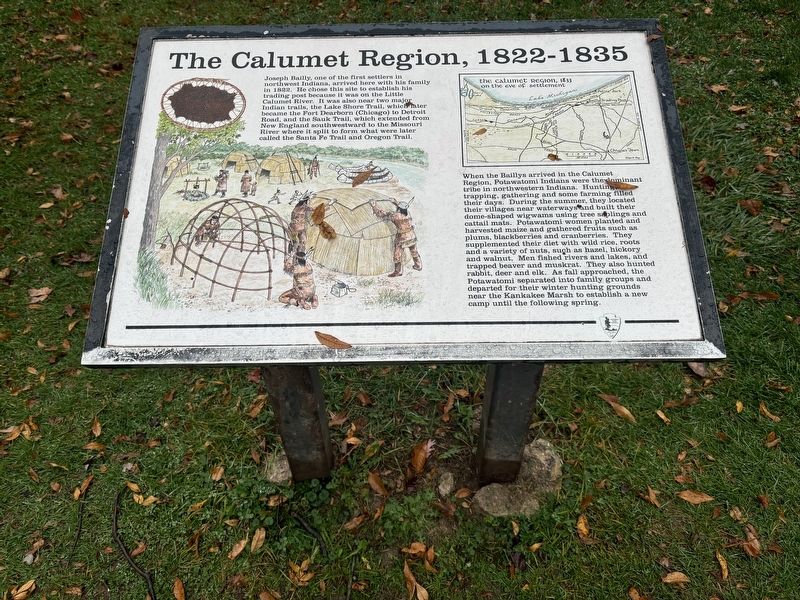
Photographed by Connor Olson, November 4, 2024
1. The Calumet Region, 1822-1835 Marker
When the Baillys arrived in the Calumet Region, Potawatomi Indians were the dominant tribe in northwestern Indiana. Hunting, trapping, gathering and some farming filled their days. During the summer, they located their villages near waterways and built their dome-shaped wigwams using tree saplings and cattail mats. Potawatomi women planted and harvested maize and gathered fruits such as plums, blackberries and cranberries. They supplemented their diet with wild rice, roots and a variety of nuts, such as hazel, hickory and walnut. Men fished rivers and lakes, and trapped beaver and muskrat. They also hunted rabbit, deer and elk. As
this page online
Erected by National Park Service.
Topics. This historical marker is listed in these topic lists: Indigenous Peoples and Communities • Settlements & Settlers. A significant historical year for this entry is 1822.
Location. 41° 37.423′ N, 87° 5.627′ W. Marker is near Porter, Indiana, in Porter County. It is in Westchester Township. It can be reached from Howe Road. The marker is at the Indiana Dunes National Park Bailly Homestead. Touch for map. Marker is at or near this postal address: 733 Howe Road, Chesterton IN 46304, United States of America. Touch for directions.

Regionally, this marker is in Northwest Indiana, specifically on the Indiana Dunes and Lake Michigan Shore, and in the Calumet Region. It is also in the American Midwest and in the Corn Belt. Globally, it is in North America, on the Great Lakes, in the Western Hemisphere, in the Western World, and in the Anglosphere. Historically, it finds itself in what was once the territory

Photographed by Connor Olson, April 4, 2024
2. The Calumet Region, 1822-1835 Marker
Other nearby markers. At least 8 other markers are within 2 miles of this marker, measured as the crow flies: Chellberg Farm and the Swedish Community (approx. 0.3 miles away); A Rain Garden (approx. 0.4 miles away); Porter War Memorial (approx. 1.3 miles away); In Memory of Joseph Bailly (approx. 1.4 miles away); Cowles Bog (approx. 1½ miles away); Legacy of Steel (approx. 1.9 miles away); Iron Brigade (approx. 2 miles away); Dunes Hi-Way (approx. 2 miles away). Touch for a list and map of all markers in Porter.
Other markers no longer nearby. The Bailly Homestead (was within shouting distance of this marker but has been confirmed missing); Highways of the Past (was about 300 feet away, measured in a direct line but has been confirmed missing).
Additional commentary.
1. Unsupported claim about the nationwide extent of the Sauk Trail
The marker claims the Sauk Trail has a nationwide extent from New England to western states. This claim does not align with most or all other sources, like Wikipedia for example.
Claim on Marker - "the Sauk Trail, which extended from New England southwestward to the Missouri River where it split to form what were later called the Santa Fe Trail and Oregon Trail."
Wikipedia on Sauk Trail - "From west to east, the trail ran from Rock Island on the Mississippi River to the Illinois River near modern Peru then along the north bank of that river to Joliet, and on to Valparaiso, Indiana. Then it ran northeasterly to La Porte and into southern Michigan running through Niles, Sturgis, Ypsilanti, and ending at the Detroit River near Detroit." Note To Editor only visible by Contributor and editor
— Submitted May 9, 2026, by Lou Donkle of Valparaiso, Indiana.
Credits. This page was last revised on May 19, 2026. It was originally submitted on November 5, 2024, by Connor Olson of Menomonee Falls, Wisconsin. This page has been viewed 273 times since then and 63 times this year. Photos: 1, 2. submitted on November 5, 2024, by Connor Olson of Menomonee Falls, Wisconsin. • Andrew Ruppenstein was the editor who published this page.
