Near Fishers Hill in Shenandoah County, Virginia — The American South (Mid-Atlantic)
Eve of Battle
"Indications were ominous"
| — | The Battle of Fisher's Hill (September 21-22, 1864) | — |
Photographed by Bradley Owen, October 12, 2024
1. Eve of Battle Marker
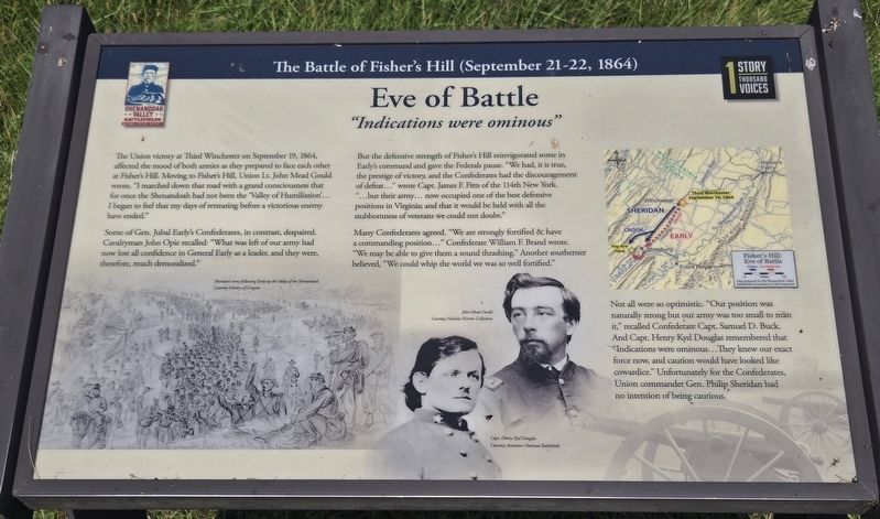
The Union victory at Third Winchester on September 19, 1864, affected the mood of both armies as they prepared to face each other at Fisher's Hill. Moving to Fisher's Hill, Union Lt. John Mead Gould wrote, "I marched down that road with a grand consciousness that for once the Shenandoah had not been the 'Valley of Humiliation'. I began to feel that my days of retreating before a victorious enemy have ended."
Some of Gen. Jubal Early's Confederates, in contrast, despaired. Cavalryman John Opie recalled: "What was left of our army had now lost all confidence in General Early as a leader, and they were, therefore, much demoralized."
But the defensive strength of Fisher's Hill reinvigorated some in Early's command and gave the Federals pause. "We had, it is true, the prestige of victory, and the Confederates had the discouragement of defeat..." wrote Capt. James F. Fitts of the 114th New York. "...but their army... now occupied one of the best defensive positions in Virginia; and that it would be held with all the stubbornness of veterans we could not doubt."
Many Confederates agreed. "We are strongly fortified &
this page online
Not all were so optimistic. "Our position was naturally strong but our army was too small to man it," recalled Confederate Capt. Samuel D. Buck. And Capt. Henry Kyd Douglas remembered that "Indications were ominous... They knew our exact force now, and caution would have looked like cowardice." Unfortunately for the Confederates, Union commander Gen. Philip Sheridan had no intention of being cautious.
(Captions):
Sheridan's army following Early up the Valley of the Shenandoah.
Courtesy Library of Congress
John Mead Gould.
Courtery Nicholas Picerno Collection
Capt. Henry Kyd Douglas.
Courtesy Antietam National Battlefield
Erected 2024 by Shenandoah Valley Battlefields Foundation.
Topics. This historical marker is listed in this topic list: War, US Civil. A significant historical date for this entry is September 19, 1864.
Location. 38° 59.298′ N, 78° 24.999′ W. Marker is near Fishers Hill, Virginia, in Shenandoah County. It can be reached
Photographed by Bill Coughlin, May 6, 2026
2. Eve of Battle Marker

Regionally, this marker is in the Shenandoah Valley. It is also in the American South, specifically in the Upper South, and in the Mid-Atlantic. Globally, it is in North America, the Western Hemisphere, the Western World, and the Anglosphere. Historically, it finds itself in what was once the territory of the Mississippian Culture, one of the original Thirteen Colonies, one of the Confederate States of America, and the Antebellum South.
Other nearby markers. At least 8 other markers are within walking distance of this marker: The Fight for the "Bull Pens" (about 300 feet away); Confederate Gibraltar (about 400 feet away); Pegram's Division Collapses (about 700 feet away); Ramseur's Hill (about 700 feet away); Crook's Flanking Movement (approx. 0.2 miles away); The Coming Storm (approx. 0.2
Photographed by Bradley Owen, October 12, 2024
3. Eve of Battle Marker
Other markers no longer nearby. Battle of Fisher’s Hill (was a few steps from this marker but has been permanently removed); Fisher’s Hill (was about 300 feet away, measured in a direct line but has been permanently removed); a different marker also named Fisher's Hill (was about 400 feet away but has been permanently removed); a different marker also named Fisher’s Hill (was about 600 feet away but has been permanently removed); a different marker also named Fisher’s Hill (was approx. 0.2 miles away but has been permanently removed); a different marker also named Fisher's Hill (was approx. 0.2 miles away but has been permanently removed).
Regarding Eve of Battle. Marker includes a map: Fisher's Hill: Eve of Battle.
Related marker. Click here for another marker that is related to this marker. This marker has replaced another near this location.
Credits. This page was last revised on May 11, 2026. It was originally submitted on November 6, 2024, by Bradley Owen of Morgantown, West Virginia. This page has been viewed 187 times since then and 25 times this year. Photos: 1. submitted on November 6, 2024, by Bradley Owen of Morgantown, West Virginia. 2. submitted on May 6, 2026, by Bill Coughlin of Woodland Park, New Jersey. 3. submitted on November 6, 2024, by Bradley Owen of Morgantown, West Virginia.
