
Danvers in Essex County, Massachusetts — The American Northeast (New England)
The Institution

Photographed by Duane and Tracy Marsteller, October 1, 2024
1. The Institution Marker
[Left panel, clockwise from top left]
• 1878 engraving of the newly constructed hospital.
• An enclosed sunporch added to the front of the brick exterior of the wings in 1921.
• An intricately designed flower garden laid out at the rear of the Kirkbride complex. The garden attracted huge numbers of visitors.
• This circa 1920s male wing hallway includes rooms on both sides and a parlor with triple windows seen at the far end of the hallway.
[Middle panel, clockwise from top left]
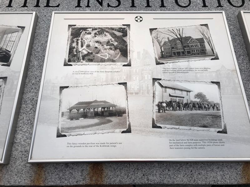
• A circa 1990 aerial view of the State Hospital complex on top of Hathorne Hill.
• “The Gray Gables” was an 1997 Queen Anne style building used as a nursing school and residence, the second such school opened in Massachusetts.
• On the land below the hill were numerous buildings used for mechanical and farm purposes. This 1920s photo shows part of the farm complex with multiple pairs of horses and their teamsters posing for the camera.
• This fancy wooden pavilion was made for patients' use on the grounds to the rear of the Kirkbride wings.
[Right panel, clockwise from top left]
• A circa 1930s male admission ward. “All patients
this page online
• Occupational therapy was carried out on a large scale. Here workers are at numerous looms, while in the foreground a patient works on a sewing machine in the upholstery work area.
• The 100,000 square foot “Bonner Medical Building” was constructed in 1955.
• The hospital's engine room with Assistant Engineer Carter at the standing desk.
Topics. This historical marker is listed in this topic list: Science & Medicine. A significant historical year for this entry is 1975.
Location. 42° 34.781′ N, 70° 58.427′ W. Marker is in Danvers, Massachusetts, in Essex County. It is on Kirkbride Drive, on the right when traveling east. Marker is in the Danvers State Hospital Memorial Plaza in the Bradlee Danvers residential complex. Touch for map. Marker is at or near this postal address: 50 Kirkbride Dr, Danvers MA 01923, United States of America. Touch for directions.

Regionally, this marker is on Massachusetts’ North Shore, in Greater Boston, and in the Merrimack Valley. It is also in the American Northeast, in New England,

Photographed by Duane and Tracy Marsteller, October 1, 2024
2. The Institution Marker (left panel)
Other nearby markers. At least 8 other markers are within 2 miles of this marker, measured as the crow flies: The People (here, next to this marker); The Danvers State Hospital (a few steps from this marker); National Historic Landmark (about 500 feet away, measured in a direct line); Derby Summer House (approx. 0.6 miles away); Village Training Field (approx. one mile away); Deacon Nathaniel Ingersoll (approx. one mile away); The 1681 Salem Village Parsonage (approx. 1.1 miles away); The 1734 Addition (approx. 1.1 miles away). Touch for a list and map of all markers in Danvers.
Photographed by Duane and Tracy Marsteller, October 1, 2024
3. The Institution Marker (middle panel)

Photographed by Duane and Tracy Marsteller, October 1, 2024
4. The Institution Marker (right panel)

Photographed by Duane and Tracy Marsteller, October 1, 2024
5. The Institution Marker
The featured marker panels are on the left.
Credits. This page was last revised on November 10, 2024. It was originally submitted on November 10, 2024, by Duane and Tracy Marsteller of Murfreesboro, Tennessee. This page has been viewed 155 times since then and 14 times this year. Photos: 1, 2, 3, 4, 5. submitted on November 10, 2024, by Duane and Tracy Marsteller of Murfreesboro, Tennessee.
