New York Mills in Otter Tail County, Minnesota — The American Midwest (Upper Plains)
Continental Divide Monument
October 24, 2024
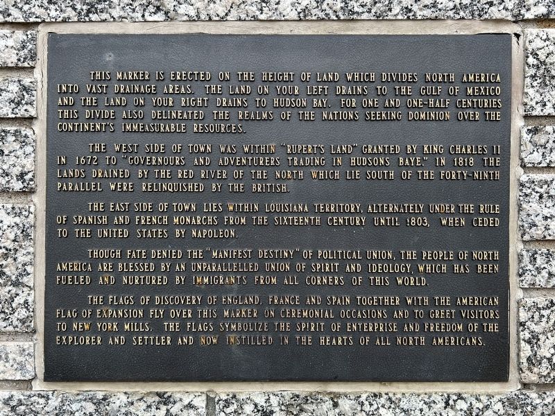
1. Continental Divide Monument Marker
The west side of town was within "Rupert's Land" granted by King Charles II in 1672 to "governours and adventurers trading in Hudsons Baye." In 1818 the lands drained by the Red River of the North which lie south of the forty-ninth parallel were relinquished by the British.
The east side of town lies within Louisiana Territory, alternately under the rule of Spanish and French monarchs from the sixteenth century until 1803, when ceded to the United States by Napoleon.
Though fate denied the "manifest destiny" of political union, the people of North America are blessed by an unparallelled union of spirit and ideology, which as been fueled and nurtured by immigrants from all corners of this world.
The flags of discovery of England, France and Spain together with the American
this page online
Erected by the New York Mills Lions Club.
Topics. This historical marker and monument is listed in these topic lists: Settlements & Settlers • Waterways & Vessels. A significant historical year for this entry is 1672.
Location. 46° 31.093′ N, 95° 22.623′ W. Marker is in New York Mills, Minnesota, in Otter Tail County. It is on Centennial 84 Drive (County Highway 84) east of Walker Avenue, on the right when traveling east. Located in Central Park. Touch for map. Marker is in this post office area: New York Mills MN 56567, United States of America. Touch for directions.

Regionally, this marker and monument is in the American Midwest and in the Corn Belt. Globally, it is in North America, the Western Hemisphere, the Western World, and the Anglosphere. Historically, it finds itself in what was once Rupert’s Land, the territory of the Mississippian Culture, and the Louisiana Purchase.

October 24, 2024
2. Illustration of the Continental Divide through Minnesota, South Dakota, and North Dakota
Other nearby markers. At least 8 other markers are within 12 miles of this marker, measured as the crow flies: New York Mills (here, next to this marker); Memorial to the Finnish Pioneers (a few steps from this marker); Central Park Memorial (a few steps from this marker); Leaf City (approx. 8.7 miles away); Delbert Thalmann Park (approx. 10.7 miles away); Perham (approx. 10.8 miles away); Arrival of the Northern Pacific Railway at Perham (approx. 10.8 miles away); Otter Tail City (approx. 11½ miles away). Touch for a list and map of all markers in New York Mills.
Also see . . .
1. Continental Divide Monument | New York Mills - Otter Tail County, MN. (Submitted on November 20, 2024.)
2. New York Mills celebrates 125th in style - Detroit Lakes Tribune. (Submitted on November 20, 2024.)
Additional keywords. Centennial Monument

October 24, 2024
3. Continental Divide Monument Fountain
"As the water falls and divides upon this stone, the rains falling upon this park flow both north and south to the seas."

October 24, 2024
4. Continental Divide Monument

October 24, 2024
5. Time Capsule, nearby
Open 2009 and every 25 years thereafter
July 1984
July 1984
Credits. This page was last revised on November 20, 2024. It was originally submitted on November 20, 2024. This page has been viewed 268 times since then and 74 times this year. Photos: 1, 2, 3, 4, 5. submitted on November 20, 2024.
