
Murfreesboro in Rutherford County, Tennessee — The American South (East South Central)
Oaklands
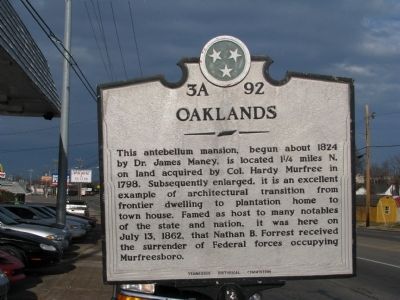
Photographed by Tom Gillard, December 30, 2009
1. Oaklands Marker
Erected by Tennessee Historical Commission. (Marker Number 3A 92.)
Topics and series. This historical marker is listed in this topic list: War, US Civil. In addition, it is included in the Tennessee Historical Commission series list. A significant historical date for this entry is July 13, 1862.
Location. 35° 50.393′ N, 86° 23.26′ W. Marker is in Murfreesboro, Tennessee, in Rutherford County. It is on Broad Street (U.S. 41), on the left when traveling north. Touch for map. Marker is in this post office area: Murfreesboro TN 37130, United States of America. Touch for directions.

Regionally, this marker is in Middle Tennessee and in Greater Nashville. It is also in the American South and
this page online
Other nearby markers. At least 8 other markers are within walking distance of this marker: Bradley Academy (about 500 feet away, measured in a direct line); Ancient Trails (about 600 feet away); Those Who Used the Spring First (about 600 feet away); Settlers Discover the Spring (about 700 feet away); A Town Emerges on the Water's Edge (about 700 feet away); Antebellum Prosperity and Institutional Growth (about 700 feet away); The Occupied Town in War and Reconstruction (about 700 feet away); a different marker also named The Occupied Town in War and Reconstruction (about 700 feet away). Touch for a list and map of all markers in Murfreesboro.
Related marker. Click here for another marker that is related to this marker. Mary Noailles Murfree
Also see . . . Hardee Murfree. Makes comments on his daughter, Mary Noailles Murfree.

Photographed by Duane Marsteller
2. Oaklands Marker
Credits. This page was last revised on February 15, 2020. It was originally submitted on December 31, 2009, by Tom Gillard of Tullahoma, Tennessee. This page has been viewed 1,303 times since then and 18 times this year. Last updated on January 2, 2010, by Tom Gillard of Tullahoma, Tennessee. Photos: 1. submitted on December 31, 2009, by Tom Gillard of Tullahoma, Tennessee. 2. submitted on February 15, 2020, by Duane and Tracy Marsteller of Murfreesboro, Tennessee. • Craig Swain was the editor who published this page.
