
Port Perry in Durham Region, Ontario — Central Canada (North America)
Township of Scugog Land Acknowledgement
Photographed by Cosmos Mariner, June 2, 2024
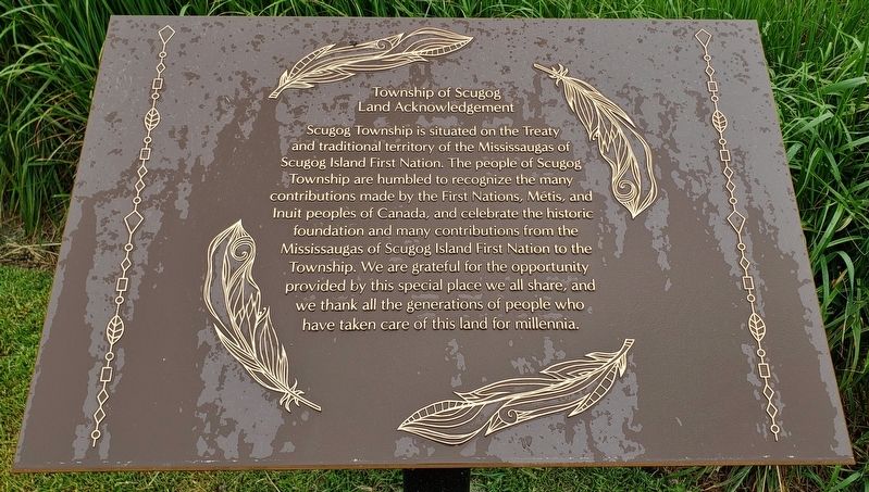
1. Township of Scugog Land Acknowledgement Marker
Scugog Township is situated on the Treaty and traditional territory of the Mississaugas of Scugog Island First Nation. The people of Scugog Township are humbled to recognize the many contributions made by the First Nations, Métis, and Inuit peoples of Canada, and celebrate the historic foundation and many contributions from the Mississaugas of Scugog Island First Nation to the Township. We are grateful for the opportunity provided by this special place we all share, and we thank all the generations of people who have taken care of this land for millennia.
Topics. This historical marker is listed in these topic lists: Indigenous Peoples and Communities • Settlements & Settlers.
Location. 44° 6.318′ N, 78° 56.712′ W. Marker is in Port Perry, Ontario, in Durham Region. It is at the intersection of Perry Street and North Street, on the right when traveling north on Perry Street. The marker is located along the sidewalk, directly in front of the Township of Scugog building. Touch for map. Marker is at or near this postal address: 181 Perry Street, Port Perry ON L9L 1B9,
this page online

Regionally, this marker is in Greater Toronto, specifically on the Golden Horseshoe, in the York, Durham and Headwaters Area, and in the Toronto Metropolitan Area. It is also in Central Canada. Globally, it is in North America, on the Great Lakes, in the Western Hemisphere, in the Western World, and in the Anglosphere. Historically, it finds itself in what was once a British colony, the Viceroyalty of New France, the Haudenosaunee (Iroquois) Confederacy, and Rupert’s Land.
Other nearby markers. At least 8 other markers are within walking distance of this marker: Independent Order of Odd Fellows (within shouting distance of this marker); The Courtice Block (within shouting distance of this marker); The Harrington Block (within shouting distance of this marker); The Jessop Block (about 90 meters away, measured in a direct line); The Currie Block (about 90 meters away); Wm. L. Parrish Block (about 90 meters away); Jones Brothers Block (about 90 meters away); John W. Davis Block (about 90 meters away). Touch for a list and map of all markers in Port Perry.
Also see . . . Mississaugas of Scugog Island First Nation.

Photographed by Cosmos Mariner, June 2, 2024
2. Township of Scugog Land Acknowledgement Marker
The marker is located directly in front of the Township of Scugog building.
Excerpt: The first Mississauga people to settle in the basin of Lake Scugog around 1700 appreciated the bountiful resources available in the virgin forests and unspoiled wetlands. Game and fur animals, waterfowl and fish abounded, and wild rice grew in profusion in the shallow waters. The people flourished in this paradise for nearly a century until the British arrived with their insatiable appetite for aboriginal land. Having just lost the American War of Independence, British refugees came flooding north into Upper Canada seeking new land.(Submitted on November 22, 2024, by Cosmos Mariner of Cape Canaveral, Florida.)Government officials were soon conducting land acquisition treaties with Mississauga and Ojibwa people who neither understood the language of these powerful strangers nor fully grasped the revolutionary concept of permanently selling their Mother Earth. Millions of acres of valuable native lands were given up through these treaties with very little received in return.

Photographed by Cosmos Mariner, June 2, 2024
3. Township of Scugog Building
Credits. This page was last revised on November 22, 2024. It was originally submitted on November 22, 2024, by Cosmos Mariner of Cape Canaveral, Florida. This page has been viewed 286 times since then and 46 times this year. Photos: 1, 2, 3. submitted on November 22, 2024, by Cosmos Mariner of Cape Canaveral, Florida.
