Parowan in Iron County, Utah — The American Mountains (Southwest)
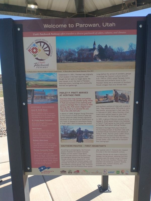
Welcome to Parowan, Utah
Photographed by Tom Bosse, July 29, 2024
1. Welcome to Parowan, Utah Marker
[Caption]: Utah’s Patchwork Parkway offers travelers a diverse patchwork of colors, cultures, and climates.
[Caption]: Photos below: Parowan Valley & Jessie N. Smith Home. Photo above: Rock Church Museum, Circa 2012.
Established in 1851, Parowan was originally a fort located in the town square. Even though the fort walls no longer stand, the town square is still the heart of Parowan, featuring historic buildings and community festivals and gatherings.
Long before the arrival of pioneers, groups including the Fremont culture (around A.D. 700 to 1250) called Parowan home Pithouses and artifacts found in the Parowan Valley are a reminder of Southern Paiute villages that once thrived here.
Parley P. Pratt Arrives at Heritage Park
Tired from their long journey and getting nourishment from the plentiful spring, Parley P. Pratt and members of his exploring party camped at Heritage Park in January of 1850. Not long after, Pratt raised a flagpole (just above the park) as he declared the area “City of the Little Salt Lake”.
In March of 1849, Brigham Young (President of The Church of Jesus Christ of Latter-day Saints)
this page online
In 18851, a group of Mormon pioneers led be George A. Smith would follow in the footsteps of Parley P. Pratt’s group as they briefly camped at Heritage Park before settling Parowan.
Parowan’s Heritage Park pays tribute to the founding pioneers of Southern Utah with a pioneer tribute monument and statues of Parley P. Pratt, Paulina Lyman (186-1912), and handcart pioneers (many Mormon pioneers traveling to Utah from the eastern United States used handcarts to transport their belongings.
Southern Paiutes – First Inhabitants
According to archaeologists, the Fremont people inhabited the western Colorado Plateau and the eastern Great Basin, which includes portions of Southern Utah. Archaeologists believe that the Southern

Photographed by Tom Bosse, July 29, 2024
2. Welcome to Parowan, Utah Marker
Southern Paiutes do not make a distinction between the two groups, believing that their ancestors were the people living in Parowan Valley. At one time, Southern Paiutes’ land extended into California, southern Nevada, southern Utah, northern Arizona, and southwestern Colorado.
Historic Buildings
Jesse N. Smith House
35 W. 100 South, Parowan
Built in 1858 by original pioneers and believed to be the oldest standing adobe home in Southern Utah.
Dr. Priddy Meeks Farmstead
20 N. 400 West, Parowan
Built around 1857 and home to the first doctor in Parowan.
Rock Church
Town Square between Center and 100 South on Main Street, Parowan
Built in 1863, it now serves as a museum and genealogy resource featuring numerous artifacts.
Bishop’s Store-house
20 N. 100 West, Parowan
The 1885 Store-house was established by Mormons to provide goods

Photographed by Tom Bosse, July 29, 2024
3. Welcome to Parowan, Utah Marker
Parowan Community Theatre
27 North Main Street, Parowan
The “Aladdin” was a welcome retreat during the 1930s Depression Era. In the 1990s, Parowan City purchased the building and restored it back to its original façade. Various musicals and plays are performed annually by local residents.
Topics. This historical marker is listed in these topic lists: Exploration • Indigenous Peoples and Communities • Settlements & Settlers. A significant historical month for this entry is January 1850.
Location. 37° 50.35′ N, 112° 49.217′ W. Marker is in Parowan, Utah, in Iron County. It is at the intersection of South Cyn Road (U.S. 143) and East 200 South Street, on the right when traveling south on South Cyn Road. Touch for map. Marker is in this post office area: Parowan UT 84761, United States of America. Touch for directions.

Regionally, this marker is in Color Country. It is also in the American Mountain West and on the Colorado Plateau. Globally, it is in North America, the Rocky Mountains, the Western Hemisphere, the Western World, and the Anglosphere. Historically, it finds itself in what was

Photographed by Tom Bosse, July 29, 2024
4. Utah’s Patchwork Parkway
Other nearby markers. At least 8 other markers are within walking distance of this marker: The “Mother Town” of Southern Utah (here, next to this marker); Paiute Indian Tribe of Utah (here, next to this marker); Explore Southern Utah (here, next to this marker); Establishing a Community (here, next to this marker); Life on the High Plateau (here, next to this marker); Following the Water (here, next to this marker); Public Works (approx. 0.3 miles away); William and Julia Lyman House (approx. 0.4 miles away). Touch for a list and map of all markers in Parowan.
Related markers. Click here for a list of markers that are related to this marker.
Also see . . . Parowan. (Submitted on November 23, 2024, by Tom Bosse of Jefferson City, Tennessee.)
Credits. This page was last revised on November 26, 2024. It was originally submitted on November 23, 2024, by Tom Bosse of Jefferson City, Tennessee. This page has been viewed 419 times since then and 149 times this year. Photos: 1, 2, 3, 4. submitted on November 23, 2024, by Tom Bosse of Jefferson City, Tennessee. • Andrew Ruppenstein was the editor who published this page.
