Parowan in Iron County, Utah — The American Mountains (Southwest)
The “Mother Town” of Southern Utah

Photographed by Tom Bosse, July 29, 2024
1. The ”Mother Town” of Southern Utah Marker
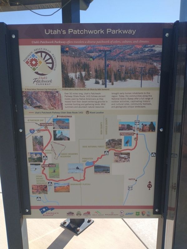
[Caption]: Utah’s Patchwork Parkway offers travelers a diverse patchwork of colors, cultures, and climates.
[Caption]: Photo below: Heritage Park & Brian Head Ski Lift Photo above: Dr. Meeks Pioneer Farmstead
Settled on January 13, 1851 by pioneers who traveled here in search of new settlements, Parowan was the first pioneer settlement in Southern Utah. The routes traveled by the early pioneers are still in use today, and many of the establishments and community traditions they gave rise to continue to thrive. Some of the early pioneers that settled Parowan went on to establish other communities in Utah and the western United States, defining Parowan as the “Mother Town” of Southern Utah.
Utah’s Patchwork Parkway offers one of the great scenic byway experiences in the western United States. Over 50 miles long, it traverses Iron and Garfield counties and provides access to Cedar Breaks National Monument and Dixie National Forest. The byway rises from around 6,000 feet in Parowan to elevations over 10,000 feet as it encounters Brian Head Peak and eventually descends to 6,600 feet as it approaches Panguitch.
The
this page online
Topics. This historical marker is listed in these topic lists: Roads & Vehicles • Settlements & Settlers. A significant historical date for this entry is January 13, 1851.
Location. 37° 50.349′ N, 112° 49.217′ W. Marker is in Parowan, Utah, in Iron County. It is at the intersection of South Cyn Road (U.S. 143) and East 200 South Street, on the right when traveling south on South Cyn Road. Touch for map. Marker is in this post office area: Parowan UT 84761, United States of America. Touch for directions.

Regionally, this marker is in Color Country. It is also in the American Mountain West and on the Colorado Plateau. Globally, it is in North America, the Rocky Mountains, the Western Hemisphere, the Western World, and the Anglosphere. Historically, it finds itself in what was once New Spain and also Mexico’s Alta California.
Other nearby markers. At least 8 other markers
Photographed by Tom Bosse, July 29, 2024
2. Utah’s Patchwork Parkway
Related markers. Click here for a list of markers that are related to this marker.
Also see . . .
1. Parowan, Utah. Wikipedia entry (Submitted on November 23, 2024, by Tom Bosse of Jefferson City, Tennessee.)
2. Utah's Patchwork Parkway National Scenic Byway. Visit Utah website entry (Submitted on November 23, 2024, by Tom Bosse of Jefferson City, Tennessee.)

Photographed by Tom Bosse, July 29, 2024
3. The ”Mother Town” of Southern Utah Marker

Photographed by Tom Bosse, July 29, 2024
4. The ”Mother Town” of Southern Utah Marker
Credits. This page was last revised on November 27, 2024. It was originally submitted on November 23, 2024, by Tom Bosse of Jefferson City, Tennessee. This page has been viewed 274 times since then and 45 times this year. Photos: 1, 2, 3, 4. submitted on November 23, 2024, by Tom Bosse of Jefferson City, Tennessee. • Andrew Ruppenstein was the editor who published this page.
