Tellico Plains in Monroe County, Tennessee — The American South (East South Central)
Unicoi Turnpike Trail
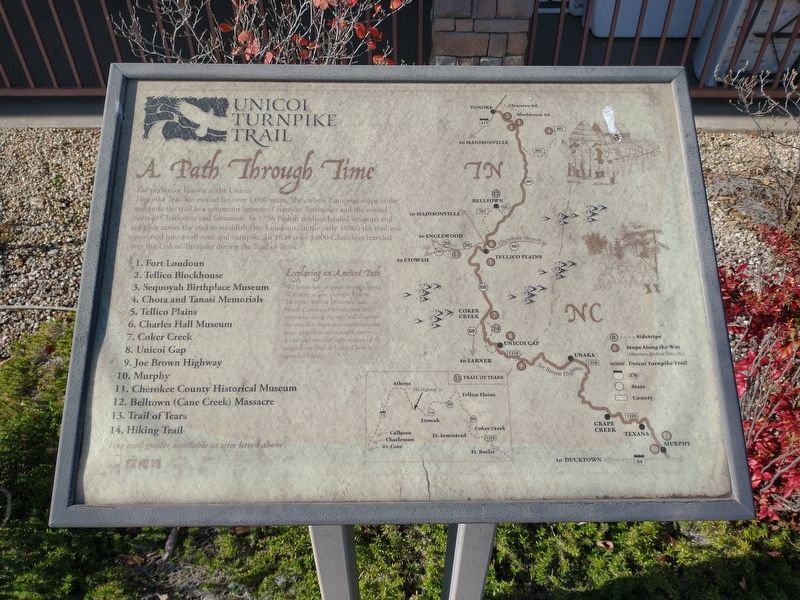
A Path Through Time
Photographed by Tom Bosse, November 22, 2024
1. Unicoi Turnpike Trail Marker
1. Fort Loudoun
2. Tellico Blockhouse
3. Sequoyah Birthplace Museum
4. Chota and Tanasi Memorials
5. Tellico Plains
6. Charles Hall Museum
7. Coker Creek
8. Unicoi Gap
9. Joe Brown Highway
10. Murphy
11. Cherokee County Historical Museum
12. Belltown (Cane Creek) Massacre
13. Trail of Tears
14. Hiking Trail
Exploring an Ancient Path
We invite you to travel through layers of history as you trace the Unicoi Turnpike Trail in Tennessee and North Carolina. Historic sites and museums along the way will illustrate the role this important transportation played in our nation's history. A two and one half mile section of the
this page online
Topics. This historical marker is listed in this topic list: Roads & Vehicles. A significant historical year for this entry is 1756.
Location. 35° 21.994′ N, 84° 17.813′ W. Marker is in Tellico Plains, Tennessee, in Monroe County. It is at the intersection of Cherohala Skyway and Herford Street, on the left when traveling south on Cherohala Skyway. Marker is located outside the Charles Hall Museum. Touch for map. Marker is at or near this postal address: 229 Cherohala Skyway, Tellico Plains TN 37385, United States of America. Touch for directions.

Regionally, this marker is in East Tennessee. It is also in the American South, specifically in the Upper South, in Appalachia, and specifically in Southern Appalachia. Globally, it is in North America, the Western Hemisphere, the Western World, and the Anglosphere. Historically, it finds itself in what was once the original Cherokee Nation, the territory of the Mississippian Culture, one of the Confederate States of America, and the Antebellum South.
Other nearby markers. At least 8 other markers are within walking distance of

Photographed by Tom Bosse, November 22, 2024
2. Unicoi Turnpike Trail Marker

Photographed by Tom Bosse, November 22, 2024
3. Unicoi Turnpike Trail Marker
Credits. This page was last revised on December 2, 2024. It was originally submitted on November 28, 2024, by Tom Bosse of Jefferson City, Tennessee. This page has been viewed 271 times since then and 43 times this year. Photos: 1, 2, 3. submitted on November 28, 2024, by Tom Bosse of Jefferson City, Tennessee. • James Hulse was the editor who published this page.
