
Antananarivo in Antananarivo Renivohitra, Analamanga, Madagascar — Africa (Indian Ocean)
Ny Lemak'i Betsimitatatra
⎯⎯⎯
Ny Farihin'anosy
⎯⎯⎯
Ny Toerana Misy Ireo Minisitera

Photographed by J. Makali Bruton, August 28, 2024
1. Ny Lemak'i Betsimitatatra / Ny Farihin'anosy / Ny Toerana Misy Ireo Minisitera Marker

Tany am-piandohana, honahona tsotra no teo Betsimitatatra, nampian'n anon'orana sy ny ranon'lkopa Nohodidinina fefiloha tsikelikely izany hatramin'ny andron'Andrianjaka (1610-1630) mba hahazoana manao azy ho tanimbary. Nanamarikalihy toerana iny ny fanajariana ny toeraha sy fananganan'ny olona trano teny ny hatramin'ny fiandohan'ny taonjato XIX. Ny mpanjaka Radama (1810-1826)osa no nanomboka nanarina ny vohitr Ambohijanahary (eo amin'ny la ankavia), izay mbola rakotra ala tamin izany, sy nanototra tany ani Mahamasina (misy ny kianja filalaovam-baolina A amin'izao fotoana izao). Tiany ny hanamboatra ity farany ho toerana voalohany a fanaovana matso lehibe. Ny mpanjakavavy Ranavalona I (1828-1861) kosa fa no nanamaina ny toerana tamin'ny taoria 1833. Nampitondraina ny anarana va hoe «Mahamasina » ilay toerana taty aoriana, nandritra ny nanosorana az an-dRadama II (1861-1863) ho mpanjaka Baha fanaovana hazakaza-tsoavaly i Mahamasina faha fanjanahan-tany, teo amin'io toerana io kosa i Tsiranana no anambara ampahibemaso ny fahaleovan-tenani Madagasikara ny taona 1960. Nanorenan'ny fanjakana malagasy trano lehibe atac Lapan'ny Fanatanjahan-tena sy Kolontsaina eo anilany, tafo miloko mena, miendrika lolo.
Ny Farihin'anosy
Tsy lavitra ny kianja Mahamasina, indro misy farihy miendrika fo io no Anosy. Tany am-boalohany, dia nohajariana hanondrahana ny tanimbarin'ny andriana ny farihin'Anosy. Nohajariana ireo honahona teo aminy tamin'ny c faha Radama I, ka naroronana farihy. Namoronan'i James Cameron endrika vaovao sy mahafinaritra teo ny taona 1830, nasiany fefiloha ny manodidina azy, nananganany nosy kely teo afovoany, ka nanamboarany toeram-panefena vy Nofefen'ny mpanjakavavy Ranavalona tamboho ny farihy ny taona 1854, ary nasainy hanamboaran'i Laborde tranom-panjakan'ny andriamanjaka. Hay tsangambato ho an'ireo maty kosa dia naorina tamin'ny taona 1927 ho fahatsiarovana ireo miaramila malagasy maty an/ady ho an'i Frantsa nandritra ny ady lehibe voalohany. Ny taona 1933 no nametrahana ilay sary vongana anjely eo amboniny, ka ilay mpanao sary sökitra Barberis no nanamboatra azy.
Ny Toerana Misy Ireo Minisitera
Saika miorina eo amin'ny ilany havian'ny farihin Anosy avokoa ireo minisitera. Io toerana io dia vokatr'ireo fanotofana tany natao tamin'ny Repoblika Voalohany, nandritra ny taona 60 Endrika samihafa no nanamboarana azy iremisy ny manana endrika tongotra elefanta», toy ny an'ny minisiteran'ny atitany sy ny filaminam-bahoaka, ao ny boribory, fantatra amin'ny fanatobiana ny voka-pifidianana amin'ny fotoam-pifidianana, eo koa ny manana endrika artoy ny kintana, ny eo amin'ny minisiteran'ny fanabeazam-pirenena, sns.Eo akaiky eo koa no ahitana ny tranom-bokim-pirenena, ny radio Madagasikara, ny fitsarana... Mbola hita amin'ny sary tranainy nalaina tamin'ny taona 1933 ny fisian'ny tanimbary tamin'iny faritra iny.
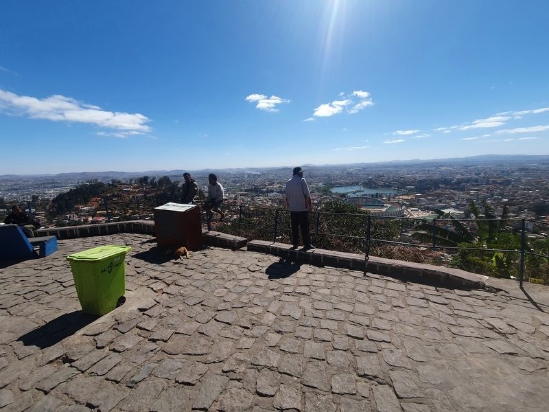
Avy ankavia miankavanana, dia tazana avy eto (jereo ny sary) ny tendrombohitra midezan Ankaratra (2641m), ireo tendrombohitra manan-tantara toa an'Antsahadinta, Antongona ary Andringitra.
La Plaine de Betsimitatatra
Au début, toute cette partie basse était de simple marais alimenté par des eaux de pluie et de l'lkopa. Ilva, peu à peu, étre entouré de digues depuis Andrianjaka (1610-1630) pour la préparation des rizières. L'aménagement et l'installation des habitations ont marqué le paysage depuis le début du XIXe siecle. Le roi Radama I (1810-1828) a commencé à raser la colline boisée d'Ampohijanahary (à gauche) et remblayer Mahamasina (là où il y a le stade).
Le jeune roi y voulait réaliser le premier champ de manoeuvres royales. Asséché en 1833 par Ranavalona I (1828-1861), ce lieu prendra plus tard le nom de Mahamasina lors du couronnement de Radama II (1861-1863). Hippodrome sous la colonisation, c'était à cet endroit que Tsiranana declara l'indépendance en 1960. Le bâtiment à toiture rouge en forme de papillon abrite le palais national de Sports et de la Culture.
Le Lac Anosy
Juste après le stade, oh remarque tout de suite le lac en forme de cœur Anosy. Il fut aménagé au début pour irriguer les rizières royales. Au temps du roi Radama I les marais ont été aménagés pour créer un lac artificiel. En 1830, James Cameron modèle la forme du lac en le cernant d'une digue et organise un îlot pour y créer un atelier de forgerons: En 1854, la Reine Ranavalona I fit cerner le lac d'un tamboho, et fit bâtir, par Laborde, des résidences royales sur les lieux. Le monument aux morts date de 1927, et commémore la mort au front des soldats malgaches pour la France pendant la Première Guerre V Mondiale La statue de l'ange brandissant une couronne de laurier, ajoutée en 1933, fut Oréalisée par le sculpteur Barberis
Les Quartiers des Ministeres
Relativement récent, ce quartier à gauche du lac résulte d'une série de remblayages qui remontent à la Première République, dans les années 60. Nous pouvons énumérer un par un au passage les différents ministères, pour certains par leur sobriquet: «Patte d'éléphant» pour le ministère de l'intérieur, et sa coupole célèbre pour les décomptes des voies durant les élections, tarte» pour le ministère de l'éducation nationale, etc. A côté se trouve la Bibliothèque Nationale, la station de la Radio Madagascar, le Tribunal.... Sur la photo ancienne de 1933 on remarque encore la présence des rizières sur cette partie de la ville.
Ici, on aperçoit à l'horizon de gauche à droite (photo) le massif d'Ankaratra (2641m, sommet de l'Imerina) les collines historiques d'Antsahadinta, Antongona et d'Andringitra.
Textes révisés et validés par: Pr. Ratolo Andrianaivoarivony et Doc. Rasoarifetra Bako (Consultants scientifiques)
Crédits photos: Ortana, Anta
Maquette: Hervé Rakotovahoaka
The Plain of Betsimitatatra
At the beginning, this entire lower part was a simple marsh fed by rainwater and the lkopa. It will, little by little, be surrounded by dikes since Andrianjaka (1610-1630) for the preparation of rice fields. Its layout and the installation of dwellings have marked the landscape since the beginning of the nineteenth century. King Radama I (1810-1828) began razing the wooded hill of Ampohijanahary (left) and fill in Mahamasina (where the stadium is).
The young king wanted to create the first royal field of manoeuvres there. Drained in 1833 by Ranavalona I (1828-1861), this place would later take the name of Mahamasina at the coronation of Radama II (1861-1863). A hippodrome under colonization, it was at this place that Tsiranana declared independence in 1960. The building with a red roof in the shape of a butterfly is home to the National Palace of Sports and Culture.
Lake Anosy
Just after the stadium, one immediately notices the heart-shaped Lake Anosy. It was originally built to irrigate the royal rice fields. At the time of King Radama I, the marshes were developed to create an artificial lake. In 1830, James Cameron modeled the shape of the lake by surrounding it with a dike and organized an island to create a blacksmiths' workshop. In 1854, the Queen Ranavalona I had the lake surrounded by a tamboho, and had residences built by Laborde on the spot. The war memorial dates from 1927, and commemorates the death at the front of Malagasy soldiers fighting for France during the First World War. The Angel Statue brandishing a crown of Laurier, added in 1933, was made by the sculptor Barberis
The Quarters of the Ministries
Relatively recent, this district to the left of the lake is the result of a series of backfilling that dates back to the First Republic, in the 1960s. We can list the different ministries one by one in passing, some by their nickname: "Elephant's foot" for the Ministry of Finance. The Interior, and its dome famous for ballot counts during elections, “The Pie" for the Ministry of National Education, etc. Next door is the National Library, the Radio Madagascar station, the Court.... On the old photo from 1933 we can still see the presence of rice fields in this part of the city.
Here, we can see on the horizon from left to right (photo) the Ankaratra massif (2641 m, summit of Imerina) the historic hills of Antsahadinta, Antongona and Andringitra.
Texts revised and validated by: Prof. Ratolo Andrianaivoarivony and Doc. Rasoarifetra Bako (Scientific Consultants)
Photo credits: Ortana, Anta
Model: Hervé Rakotovahoaka
Topics.
this page online
Location. 18° 55.46′ S, 47° 31.865′ E. Marker is in Antananarivo, Analamanga, in Antananarivo Renivohitra. It is on Lalana Ramboatiana, on the right when traveling south. Touch for map. Marker is at or near this postal address: Lalana Ramboatiana 101, Antananarivo, Analamanga, Madagascar. Touch for directions.

Regionally, it is in Africa, specifically in Sub-Saharan Africa, in the Indian Ocean, at one of the Indian Ocean Islands and on the Swahili Coast. Historically, it finds itself in what was once a French colony.
Other nearby markers. At least 6 other markers are within walking distance of this marker: Fiangonana (within shouting distance of this marker); Lapa Mahitsielafanjaka (about 150 meters away, measured in a direct line); Translation of the Bible to Malagasy (about 150 meters away); Rova of Antananarivo (about 180 meters away); I - Rovan'antananarivo (about 240 meters away); Malagasy Soldiers Memorial (approx. 1.4 kilometers away).
Photographed by J. Makali Bruton, August 28, 2024
2. Ny Lemak'i Betsimitatatra / Ny Farihin'anosy / Ny Toerana Misy Ireo Minisitera Marker

Photographed by J. Makali Bruton, August 28, 2024
3. The view from the marker at the plains and capital city of Antananarivo
Credits. This page was last revised on November 30, 2024. It was originally submitted on November 30, 2024, by J. Makali Bruton of Washington, District of Columbia. This page has been viewed 171 times since then and 44 times this year. Photos: 1, 2, 3. submitted on November 30, 2024, by J. Makali Bruton of Washington, District of Columbia.
