Weston in Lewis County, West Virginia — The American South (Appalachia)
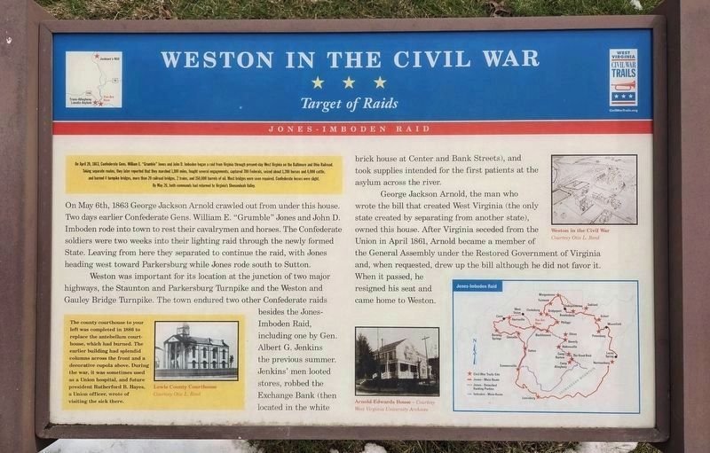
Weston In The Civil War
Target of Raids
| — | Jones-Imboden Raid | — |
Photographed by Bradley Owen, February 24, 2025
1. Weston In The Civil War Marker
On April 20, 1863, Confederate Gens. Willam E "Grumble" Jones and John D. Imboden began a raid from Virginia through present-day West Virginia on the Baltimore and Ohio Railroad Taking separate routes, they later reported that they marched 1,100 miles, fought several engagements, captured 700 Federals, seized about 1,200 horses and 4,000 cattle, and burned 4 turnpike bridges, more than 20 railroad bridges, 2 trains, and 150,000 barrels of oil. Most bridges were soon repaired. Confederate losses were slight. By May 26, both commands had returned to Virginia's Shenandoah Valley.
On May 6th, 1863 George Jackson Arnold crawled out from under this house. Two days earlier Confederate Gens. William E. "Grumble" Jones and John D. Imboden rode into town to rest their cavalrymen and horses. The Confederate soldiers were two weeks into their lighting raid through the newly formed State. Leaving from here they separated to continue the raid, with Jones heading west toward Parkersburg while Jones rode south to Sutton.
Weston was important for its location at the junction of two major highways, the Staunton and Parkersburg Turnpike
this page online
George Jackson Arnold, the man who wrote the bill that created West Virginia (the only state created by separating from another state), owned this house. After Virginia seceded from the Union in April 1861, Arnold became a member of the General Assembly under the Restored Government of Virginia and, when requested, drew up the bill although he did not favor it. When it passed, he resigned his seat and came home to Weston.
(sidebar)
The county courthouse to your left was completed in 1886 to replace the antebellum courthouse, which had burned. The earlier building had splendid columns across the front and a decorative cupola above. During the war, it was sometimes used as a Union hospital, and future president Rutherford B. Hayes, a Union officer, wrote of visiting the sick there.
(captions)
Lewis

Photographed by Bradley Owen, February 24, 2025
2. Weston In The Civil War Marker
Arnold-Edwards House with the marker on the left.
Arnold-Edwards House - Courtesy West Virginia University Archives
Weston in the Civil War Courtesy Otis L. Reed
Erected by West Virginia Civil War Trails.
Topics. This historical marker is listed in this topic list: War, US Civil. A significant historical date for this entry is May 6, 1863.
Location. 39° 2.18′ N, 80° 28.04′ W. Marker is in Weston, West Virginia, in Lewis County. It is at the intersection of Center Avenue (U.S. 19) and First Street, on the right when traveling north on Center Avenue. Located in front of the Arnold-Edwards House, currently the Lewis County office of the West Virginia University Extension Service. Touch for map. Marker is at or near this postal address: 104 Center Ave, Weston WV 26452, United States of America. Touch for directions.

Regionally, this marker is in North Central West Virginia. It is also in the American South, specifically in the Upper South, in Appalachia, and specifically in Northern Appalachia. Globally, it is in North America, the Western Hemisphere, the Western World, and the Anglosphere. Historically, it finds itself in what was once

Photographed by Bradley Owen, February 24, 2025
3. Historic Lewis County Courthouse.
Marker is off the photo to the right.
Marker is off the photo to the right.
Other nearby markers. At least 8 other markers are within walking distance of this marker: Brannon-Whelan House (within shouting distance of this marker); Lewis County War Memorial (within shouting distance of this marker); Henry Flesher (within shouting distance of this marker); Weston (within shouting distance of this marker); The Exchange Bank of Virginia and the Lewis Maxwell House (within shouting distance of this marker); Weston's First Bank/Bennett House (about 300 feet away, measured in a direct line); Shirtman (about 500 feet away); Tierney-Farnsworth Building (about 500 feet away). Touch for a list and map of all markers in Weston.
Another marker is no longer nearby. Weston In The Civil War (has been replaced with this marker).
Related marker. Click here for another marker that is related to this marker. Old CWT Marker At This Location also titled "Weston In The Civil War".
Credits. This page was last revised on July 26, 2025. It was originally submitted on December 11, 2024, by Mark Parker of Hickory, North Carolina. This page has been viewed 522 times since then and 73 times this year. Photos: 1, 2, 3. submitted on February 25, 2025, by Bradley Owen of Morgantown, West Virginia. • Bernard Fisher was the editor who published this page.
