Fort Bliss in El Paso County, Texas — The American South (West South Central)
Interim Period, 1910 - 1912
| — | Fort Bliss Main Post Historic District | — |

Photographed by Kevin W., April 13, 2016
1. Interim Period, 1910 - 1912 Marker
In 1906, the El Paso Electric Railway Company built a streetcar line to Fort Bliss five miles away. This greatly augmented contact between city and post, which had formerly been linked only by freight lines and an unpaved road.
Building 51, the 1904 post library, and Building 53, the 1909 post exchange, canteen, and bowling alley, provided the troops with educational and recreational opportunities. Other structures erected during this same period include the water tower to the north and Building 2010, a horseshoeing shop built
this page online
Building 228, the Pershing House, was built in 1910 from standard Army Quartermaster plans, the brick version of a design that can be found at other posts in stone and wood. Home to Fort Bliss Commanding Generals until 1934, the house has hosted Buffalo Bill, Mexican Generals Huerta and Obregón, Francisco Villa, and General John J. Pershing, whose residence it was from 1914 through early 1917. The first 48-star American flag flew here in 1911 in anticipation of New Mexico and Arizona statehood the following year.
Erected 1999 by Fort Bliss.
Topics. This historical marker is listed in these topic lists: Parks & Recreational Areas • Railroads & Streetcars • War, Mexican-American • War, Spanish-American. A significant historical year for this entry is 1912.
Location. 31° 48.488′ N, 106° 26.091′ W. Marker is in Fort Bliss, Texas, in El Paso County. It is on Slater Road 0.1 miles south of Chaffee Road, on the right when traveling north. Touch for map. Marker is at or near this postal address: 51 Slater Rd, El Paso TX
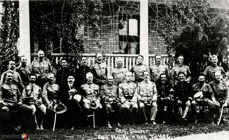
2. Photo used on the Interim Period, 1910 - 1912 Marker
Front row center are General Huerta, Brigadier General Steever, and General Tellez.

Regionally, this marker is in the Trans-Pecos & Big Bend Region. It is also in the American Borderlands and in the Southwest. Globally, it is in North America, a Gulf of Mexico state, the Western Hemisphere, the Western World, and the Anglosphere. Historically, it finds itself in what was once New Spain, the Republic of Texas, and one of the Confederate States of America.
Other nearby markers. At least 8 other markers are within walking distance of this marker: William Wallace Smith Bliss Monument (about 600 feet away, measured in a direct line); Colonel George Ruhlen (about 800 feet away); First Expansion Period (approx. 0.2 miles away); Pershing House (approx. 0.2 miles away); Robertson House (approx. 0.2 miles away); Initial Construction Period (approx. 0.2 miles away); Quarters 236 Sheridan (approx. 0.2 miles away); Polk House (approx. ¼ mile away). Touch for a list and map of all markers in Fort Bliss.
Related marker. Click here for another marker that is related to this marker. The Pershing House, mentioned on this marker.

Photographed by Kevin W., April 13, 2016
3. Interim Period, 1910 - 1912 Marker

Photographed by Kevin W., April 13, 2016
4. Interim Period, 1910 - 1912 Marker
Building 51, the 1904 post library, and Building 53, the 1909 post exchange, canteen, and bowling alley.
Credits. This page was last revised on December 22, 2024. It was originally submitted on December 22, 2024, by Kevin W. of Stafford, Virginia. This page has been viewed 571 times since then and 312 times this year. Photos: 1, 2, 3, 4. submitted on December 22, 2024, by Kevin W. of Stafford, Virginia.
