Robie Creek in Boise County, Idaho — The American West (Mountains)
Arrowrock Dam
| — | National Historic Civil Engineering Landmark | — |

Photographed by Marc Belanger, May 6, 2024
1. Arrowrock Dam Marker
Completed in 1915; Arrowrock Dam introduced a number of innovative design and construction techniques for large concrete dams it served as the prototype for other gravity-arch dams in the Western United States, and its construction demonstrated the efficiency of aerial tramways and pumped concrete systems. Measuring 350 feet high and 1,150 feet long, Arrowrock also marked the Bureau of Reclamation's first use of Ensign Valves to control flow through the outlet works
Dedicated: August 24, 2016
Erected 2016 by American Society of Civil Engineers.
Topics and series. This historical marker is listed in this topic list: Man-Made Features. In addition, it is included in the ASCE Civil Engineering Landmarks series list. A significant historical date for this entry is August 24, 2016.
Location. 43° 35.782′ N, 115° 55.219′ W. Marker is in Robie Creek, Idaho, in Boise County. It is on Arrowrock Road. Touch for map. Marker is at or near this postal address: Arrowrock Road, Boise ID 83716, United States of America. Touch for directions.

Regionally, this marker is on the Snake River Plain and in Greater Boise. It is also in the
this page online
Other nearby markers. At least 8 other markers are within 10 miles of this marker, measured as the crow flies: More's Creek (approx. 3.9 miles away); a different marker also named Arrowrock Dam (approx. 3.9 miles away); The Old Toll Road (approx. 4 miles away); The Foote Legacy in Idaho (approx. 8.7 miles away); Grimes' Creek (approx. 9.1 miles away); The Fur Trade and the Tide of Emigration (approx. 9.4 miles away); Captain Bonneville (approx. 9.4 miles away); The Hunt Expedition (approx. 9.4 miles away).
Also see . . . Arrowrock Dam, Boise River, 22 miles upstream east of Boise… (Historic American Buildings Survey). Statement of significance:
Significance: Arrowrock Dam is a key component of the Boise Project, an irrigation project designed by the United States Reclamation Service (USRS) to irrigate roughly 390,000 acres in the Boise and Payette Valleys in southwestern Idaho. This project helped to make the Boise and Payette Valleys the most agriculturally productive region(Submitted on December 31, 2024.)in Idaho. In large measure this was due to Arrowrock Dam on the Boise River, a dam that created a reservoir of more than 272,200 acre-feet of water for irrigation. Arrowrock Dam was the highest dam in the world when it was completed in 1915, measuring 350.5 feet high from bedrock. Experimental elements of its gravity-arch design would be applied to later dams that were even higher. It was only one of two Reclamation dams built with sand cement for the concrete. It was the first USRS dam built whose design required Ensign valves for its outlets to release water. Ensign valves were an important step in the rapid evolution of water regulating valves triggered by construction of ever higher dams at the beginning of the twentieth century.Photographed by Marc Belanger, May 6, 20242. Arrowrock Dam Ensign Valves
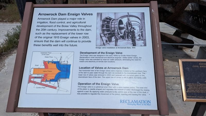

Photographed by Marc Belanger, May 6, 2024
3. Arrowrock Dam Marker site

Photographed by Marc Belanger, May 6, 2024
4. Arrowrock Dam

Walter J. Lubken (courtesy the Library of Congress), 1916
5. Arrowrock Dam
Credits. This page was last revised on December 31, 2024. It was originally submitted on December 24, 2024, by Marc Belanger of Reno, Nevada. This page has been viewed 279 times since then and 52 times this year. Photos: 1, 2, 3, 4. submitted on December 24, 2024, by Marc Belanger of Reno, Nevada. 5. submitted on December 31, 2024. • Andrew Ruppenstein was the editor who published this page.
