Hunters Glen in Plano in Collin County, Texas — The American South (West South Central)
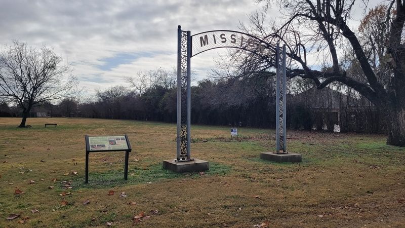
On a Mission

Photographed by James Hulse, December 26, 2024
1. On a Mission Marker
The Mathews, Carpenter and Haggard families from Kentucky became neighbors, friends and spouses. Early rural churches and schools consolidated and moved to town after the railroad spurred commerce and trade in the area which became downtown Plano. The location for the First Christian Church, begun by members of the founding families of Plano, is still along 15th Street, formerly known as Mechanic.
In 1955, W. O. Haggard and his wife Rosa donated the rent for land and the Missions gatekeeper you see today. The gatekeeper used to stand on the land which was just north of present-date Vines High School (15th Street and Stratford). The land was to be used for missionary work and revivals held by the church. Later the land was sold for development of homes and the iconic gatekeeper was removed and stored.
In 2014 The Plano Conservancy
this page online
Plano Garden Club was begun in 1947 with civic beautification as a major goal. From Haggard Park to Bethany Cemetery, the club continues to enhance Plano's public spaces with iris, daffodils, wildflowers and roses.
Captions
(Photo #1) Plano Garden Club was begun in 1947 with civic beautification as a major goal. From Haggard Park to Bethany Cemetery, the club continues to enhance Plano's public spaces with iris, daffodils, wildflowers and roses.
(Photo #2) Rose 'Mary Katy Carpenter' to be grown from cuttings of the graveside planting for its namesake who died in 1878.
This Wayside Sign was made possible through a grant from the Heritage Commission of Plano to The Plano Conservancy
Erected by The
Photographed by James Hulse, December 26, 2024
2. On a Mission Marker
Topics. This historical marker is listed in this topic list: Cemeteries & Burial Sites. A significant historical year for this entry is 1887.
Location. 33° 4.56′ N, 96° 44.229′ W. Marker is in Plano, Texas, in Collin County. It is in Hunters Glen. It is on Custer Road south of Cannes Drive. The marker is located in the Bethany Cemetery. Touch for map. Marker is at or near this postal address: 1313 Custer Road, Plano TX 75025, United States of America. Touch for directions.

Regionally, this marker is in the Prairies & Lakes Region and in the Dallas-Fort Worth Metropolitan Area. Globally, it is in North America, a Gulf of Mexico state, the Western Hemisphere, the Western World, and the Anglosphere. Historically, it finds itself in what was once New Spain, the Republic of Texas, one of the Confederate States of America, and the Antebellum South.
Other nearby markers. At least 8 other markers are within 4 miles of this marker, measured as the crow flies: Bethany Church and School (a few steps from this marker); Bethany Cemetery (within shouting distance of this marker); a different marker also named Bethany Cemetery

Photographed by James Hulse, December 26, 2024
3. On a Mission Marker
The marker on the right side is the Mission marker.
Credits. This page was last revised on December 28, 2024. It was originally submitted on December 28, 2024, by James Hulse of Medina, Texas. This page has been viewed 225 times since then and 27 times this year. Photos: 1, 2, 3. submitted on December 28, 2024, by James Hulse of Medina, Texas.
