Irving in Dallas County, Texas — The American South (West South Central)
Main Street, Irving, Texas
Photographed by Morgan Petermann
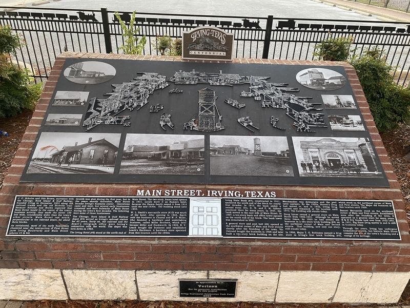
1. Main Street, Irving, Texas Marker
As envisioned, most of the early businesses clustered near the intersection of the First Street (now Irving Boulevard) and Main Street (photos #5 & #6).
Growth was slow during the first year, but in the years shortly thereafter, Main Street became Irving's business center. Operations came and went, but several early businesses remained and were bulwarks of Main Street during the town's first decades. The following were some of those businesses:
The Chicago, Rock Island & Gulf Railway depot (#4) served as Irving's railroad station for 62 years. Early on, the railroad and the depot's telegraph office were Irving's connection with the world. The depot was torn down in 1965.
this page online
The Irving Hotel (#6) stood at the north end of Main Street. The two-story, frame hotel opened in 1911. Locals knew it as Hamm's hotel, because the Hamm family owned it from 1914 until the mid-1930s. The building stood until 1954.
W.L. Smith's mercantile store (#10) was south of the hotel. After opening in 1904, Smith sold the business to Chaney and W.F. Miller, who founded a hardware and undertaking business, called Miller Brothers, which later became Miller and Duckworth. In 1922, R.V. Leach bought the business and established Leach's Hardware. A hardware store operated from this location until the 1950s.
Irving State Bank (#7), constructed in 1911, anchored the south end of the block for nearly four decades. In 1913, the bank added a second story. Drs. D.W. and F.M. Gilbert practiced there for many years. In 1947, the bank moved to the east side of Main Street. In 1967, a ten-story bank and office tower opened on the south end of the block. The bank tower was demolished in 2001.
A general store and pool hall (#6) opened at the southwest corner of Main and First streets shortly after the founding of the town. Vic Ostrand bought the business in 1908 and later built a two-story brick building on the site. Merchandise was downstairs and the pool table upstairs. By the 1920s, Hooser's Drug had moved in, and in 1932, Irving Drug opened and remained at the location until 1973. The building still stands today.
Doug Lucas owned a general store on Main Street from 1906-1931. Although he moved three times, by 1920 he had settled his business in a two-story brick building (#8) on the northwest corner of Main and Second streets. That building, now only one story, still stands today.
In 1906, Major T.G. Robinson opened a drug store in Irving's first brick building (#3), which stood on the northeast corner of Main and First streets. The Major did business at this location until 1939.
Banner Mercantile stood on the southeast corner of Main and First streets. Established soon after the founding of the town, it operated as a general store for many years. B&H Dry Goods took over from 1932-1951. In 1951, Big State Drug moved in and is still in business today.
Through the years, Irving has undergone tremendous growth, but historic Main Street remains the site of the town's founding and a vestige of its heritage.
Erected by City of Irving.
Topics. This historical marker is listed in these topic lists: Industry & Commerce • Roads & Vehicles • Settlements & Settlers.
Location. 32° 48.875′ N, 96° 56.781′ W. Marker is in Irving, Texas, in Dallas County. It is at the intersection of North Main Street and Rock Island Rd on North Main Street. Touch for map. Marker is at or near this postal address: 401 S Main St, Irving TX 75060, United States of America. Touch for directions.

Regionally, this marker is in the Prairies & Lakes Region and in the Dallas-Fort Worth Metropolitan Area. Globally, it is in North America, a Gulf of Mexico state, the Western Hemisphere, the Western World, and the Anglosphere. Historically, it finds itself in what was once New Spain, the Republic of Texas, one of the Confederate States of America, and the Antebellum South.
Other nearby markers. At least 8 other markers are within walking distance of this marker: Randle Clock Tower (a few steps from this marker); Irving Lumber Company (about 400 feet away, measured in a direct line); Caster Cabin (about 800 feet away); Britain Family (about 800 feet away); Estelle Community (approx. 0.2 miles away); Bear Creek Community (approx. 0.2 miles away); Elm Community (approx. 0.2 miles away); Heritage Park Depot (approx. 0.2 miles away). Touch for a list and map of all markers in Irving.
Credits. This page was last revised on January 1, 2025. It was originally submitted on December 30, 2024, by Morgan Petermann of Hurst, Texas. This page has been viewed 405 times since then and 72 times this year. Photo 1. submitted on December 30, 2024, by Morgan Petermann of Hurst, Texas. • James Hulse was the editor who published this page.
Editor’s want-list for this marker. A wide view photo of the marker and the surrounding area together in context. • Can you help?
