Cumberland Township near Crucible in Greene County, Pennsylvania — The American Northeast (Mid-Atlantic)
Crucible Mine
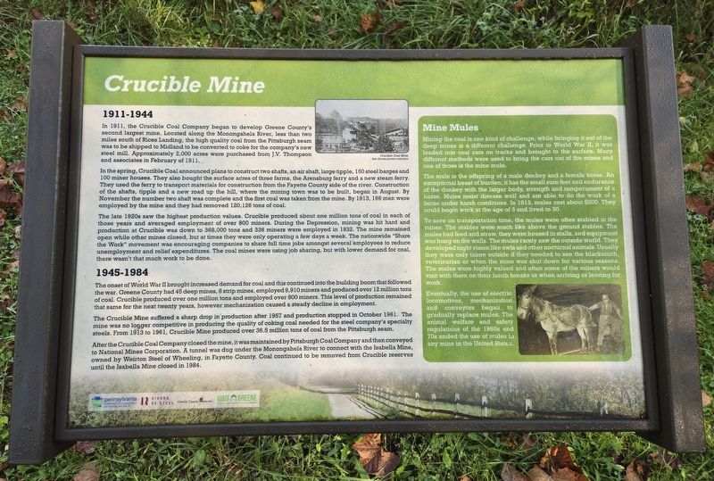
Photographed by Bradley Owen, October 9, 2024
1. Crucible Mine Marker
1911-1944
In 1911, the Crucible Coal Company began to develop Greene County's second largest mine. Located along the Monongahela River, less than two miles south of Rices Landing, the high quality coal from the Pittsburgh seam was to be shipped to Midland to be converted to coke for the company's new steel mill. Approximately 2,000 acres were purchased from J.V. Thompson and associates in February of 1911.
In the spring, Crucible Coal announced plans to construct two shafts, an air shaft, large tipple, 150 steel barges and 100 miner houses. They also bought the surface acres of three farms, the Arensburg ferry and a new steam ferry. They used the ferry to transport materials for construction from the Fayette County side of the river. Construction of the shafts, tipple and a new road up the hill, where the mining town was to be built, began in August. By November the number two shaft was complete and the first coal was taken from the mine. By 1913, 166 men were employed by the mine and they had removed 120,126 tons of coal.
The late 1920s saw the highest production values. Crucible produced about one million tons
this page online
1945-1984
The onset of World War II brought increased demand for coal and this continued into the building boom that followed the war. Greene County had 45 deep mines, 8 strip mines, employed 9,910 miners and produced over 12 million tons of coal. Crucible produced over one million tons and employed over 800 miners. This level of production remained that same for the next twenty years, however mechanization caused a steady decline in employment.
The Crucible Mine suffered a sharp drop in production after 1957 and production stopped in October 1961.

Photographed by Bradley Owen, October 9, 2024
2. Crucible Mine Marker
View is looking west.
After the Crucible Coal Company closed the mine, it was maintained by Pittsburgh Coal Company and then conveyed to National Mines Corporation. A tunnel was dug under the Monongahela River to connect with the Isabella Mine, owned by Weirton Steel of Wheeling, in Fayette County. Coal continued to be removed from Crucible reserves until the Isabella Mine closed in 1984.
Mine Mules
Mining the coal is one kind of challenge, while bringing it out of the deep mines is a different challenge. Prior to World War II, it was loaded into coal cars on tracks and brought to the surface. Many different methods were used to bring the cars out of the mines and one of those is the mine mule.
The mule is the offspring of a male donkey and a female horse. An exceptional beast of burden, it has the small sure feet and endurance of the donkey with the larger body, strength and temperament of a horse. Mules resist disease well and are able to do the work of a horse under harsh conditions. In 1913, mules cost about $200. They could begin work at the age of 3 and lived to 30.
To save on transportation time, the mules were often stabled in the mines. The stables were much like above the ground stables. The mules had feed and straw, they were housed in stalls, and equipment was hung on the walls. The mules rarely saw the outside world. They developed night vision like owls and other nocturnal animals. Usually they were only taken outside if they needed to see the blacksmith, veterinarian or when the mine was shut down for various reasons. The mules were highly valued and often some of the miners would visit with them on their lunch breaks or when arriving or leaving for work.
Eventually, the use of electric locomotives, mechanization and conveyors began to gradually replace mules. The animal welfare and safety regulations of the 1960s and 70s ended the use of mules in any mine in the United States.
(Caption):
Crucible Coal Mine.
Bob Groves private collection.
Erected 2020 by Pennsylvania Department of Conservation and Natural Resources, Rivers of Steel, Greene County Museum and Greene County Tourist Promotion Agency.
Topics. This historical marker is listed in these topic lists: Animals • Industry & Commerce • Natural Resources • Waterways & Vessels. A significant historical month for this entry is February 1911.
Location. 39° 57.188′ N, 79° 58.215′ W. Marker is near Crucible, Pennsylvania, in Greene County. It is in Cumberland Township. It is on East George Street north of Old Ferry Road (County Route 1017), on the right when traveling north. Marker is located on the Greene River Trail just east of East George Street. Touch for map. Marker is in this post office area: Crucible PA 15325, United States of America. Touch for directions.

Regionally, this marker is in the American Northeast, in the Mid-Atlantic, in Appalachia, and specifically in Northern Appalachia. Globally, it is in North America, the Western Hemisphere, the Western World, and the Anglosphere. Historically, it finds itself in what was once the Haudenosaunee (Iroquois) Confederacy and also one of the original Thirteen Colonies.
Other nearby markers. At least 8 other markers are within 2 miles of this marker, measured as the crow flies: Coal Towns (approx. 0.2 miles away); Early Coal Mining (approx. 0.2 miles away); Ferries (approx. 0.4 miles away); Crucible World War II Honor Roll (approx. half a mile away); Pittsburgh Coal Seam (approx. 0.8 miles away); Bituminous Coal (approx. 1.2 miles away); Rices Landing Community Honor Roll (approx. 1½ miles away); Foundry (approx. 1½ miles away). Touch for a list and map of all markers in Crucible.
Credits. This page was last revised on July 20, 2025. It was originally submitted on January 3, 2025, by Bradley Owen of Morgantown, West Virginia. This page has been viewed 293 times since then and 59 times this year. Photos: 1, 2. submitted on January 3, 2025, by Bradley Owen of Morgantown, West Virginia.
