Near Tallassee in Blount County, Tennessee — The American South (East South Central)
Early Tollgate

Vic Weals Collection (Box 18, Folder 795), McClung Historical Collection. Used with permission.
1. Early Tollgate Marker
This photograph and the photograph and caption in image No. 2 were first published in the 2002 book Legends of Cades Cove and the Smokies Beyond by Vic Weals (ISBN 0-9629156-2-9), both on page 138.
The photograph from which this image was made is 2½ inches square, the characteristics of a print made from Kodak 120 film negative used used in the ubiquitous Kodak Brownie cameras of the 1940s, ’50s and ’60s as well as more expensive medium format cameras like Rolleiflex, Hasselblad and Mamiya.
The photograph from which this image was made is 2½ inches square, the characteristics of a print made from Kodak 120 film negative used used in the ubiquitous Kodak Brownie cameras of the 1940s, ’50s and ’60s as well as more expensive medium format cameras like Rolleiflex, Hasselblad and Mamiya.
Erected by Tennessee Historical Commission. (Marker Number 1E-37.)
Topics. This historical marker is listed in these topic lists: Communications • Roads & Vehicles. A significant historical year for this entry is 1829.
Location. Marker has been permanently removed. It was located near 35° 29.818′ N, 83° 55.616′ W. Marker was near Tallassee, Tennessee, in Blount County. It was on Calderwood Highway (U.S. 129) 3 miles north of Deals Gap (the North Carolina state line).
The historic tollgate/tollhouse location described by multiple sources is three miles north of Deals Gap. A hiker commenting on a photo he took on May 9, 2009 titled “Toll house area, U.S. 129,” which he described as “about three road miles north of Deals Gap”, wrote, “I thought I remembered as a kid that there was a historical marker at the turnout and that the chimney was still visible below U.S. 129. ...” The approximate location coordinates listed here are for the turnout. Topographic maps show that the area across the highway from the turnout is the flattest half acre in miles, an ideal location to build a tollhouse. The paved turnout at this point could itself be further evidence that the marker was here. In the 1950s the Tennessee Department of Highways would build turnouts for historical markers it placed so motorists could
this page online
We have been informed that this marker is no longer there and will not be replaced. This page is an archival view of what was.
Regionally, this marker was in East Tennessee, in the Great Smoky Mountains, and in Greater Knoxville. It was also in the American South, specifically in the Upper South, in Appalachia, and specifically in Southern Appalachia. Globally, it was in North America, the Western Hemisphere, the Western World, and the Anglosphere. Historically, it found itself in what was once the original Cherokee Nation, the territory of the Mississippian Culture, one of the Confederate States of America, the State of Franklin, and the Antebellum South.

Other nearby markers. At least 8 other markers are within 8 miles of this location, measured as the crow flies: Shaping the Flow of the Cheoah River (approx. 4½ miles away in North Carolina); Chilhowee (approx. 5.8 miles away); a different marker also named Shaping the Flow of the Cheoah River (approx. 6.6 miles away in North Carolina); Welcome to Fontana Dam (approx. 7.6 miles away in North Carolina); The TVA System of Multi-purpose Dams (approx. 7.6 miles away in North Carolina); Fontana's First Stewards: (approx. 7.7 miles away in North Carolina); Appalachian Trail (approx. 7.7 miles away in North Carolina); Fontana Dam: (approx. 7.7 miles away in North Carolina).
More about this marker. This marker was first listed in the 1958 4th edition of

Vic Weals Collection (Box 18, Folder 795), McClung Historical Collection. Used with permission.
2. Toll Gate House
The caption reads, “Toll Gate House on Old Tennessee River Turnpike (Maryville to Franklin) near Deals Gap in Blount County, Tennessee, about 1906. George Davis & daughters, Mary and Dixie.”
Regarding Early Tollgate. This tollgate was the only tollgate in Tennessee on this turnpike.
The turnpike discussed on this marker—named the Tennessee River Turnpike—paralleled the waterway we know today as the Little Tennessee River, a river that rises in northeast Georgia and flows north through North Carolina and then Tennessee where it joins the Tennessee River itself southwest of Knoxville.
Also see . . . Tail of the Dragon History. Ronald E. Johnson’s history of the 11 mile stretch of U.S. 129 around the Tennessee-North Carolina border known as the “Tail of the Dragon” on which this historical marker was once placed. Excerpt:
As more settlers moved into the area landowners began collecting tolls for use of the road. Toll Booth Corner, located at mile 3.0, was a place to pay for the right to cross private property. There were corrals to keep the livestock in transit and meager sleeping quarters for guests to spend the night. Some who tried to cross without paying the toll were caught and supposedly hanged on the spot. ...(Submitted on January 18, 2025.)
The Dragon in the late 1920s was designated as TN 72 on the Tennessee side and NC 288 on the North Carolina side (today’s NC 28 to Fontana). Completion of the bridge near Tapoco in 1931 allowed connection of NC 108 to NC 288. In 1934 NC 108 and TN 72 were renumbered as US 129 and was most likely pavedfor the first time around that date.Promotional image from amazon.com3. Legends of Cades Cove and the Smokies Beyond2002 book by Vic Weals, available on Amazon.com. Photographs Nos. 1 and 2 were first published in this book.
Vic Weals was a columnist at the Knoxville Journal newspaper in the 1950s through ’80s. This book is based on many of his “Home Folks” (1951-1963) and “Tennessee Travels” (1976-1986) columns.
Click for more information.
This website may earn income if you use this link to make a purchase.

Additional commentary.
1. The Tennessee River Turnpike
In 1822 the Tennessee General Assembly authorized a turnpike or toll road from Maryville TN to the North Carolina line, following a route that had been a Native American trail and had then become a drover road for herding livestock to Atlantic coast markets. The improved road would be 12 feet wide with 3-foot shoulders, and with bridges as needed. Specified tolls included two cents for each head of cattle, and for “loose horses not in a drove, six and one fourth cents.” At about the same time, by agreement North Carolina authorized two sections of turnpike that would continue from the TN/NC line to Franklin NC.
In 1825 Tennessee authorized a new set of road builders/operators to finish the difficult mountainous section of the turnpike from Abrams Creek to the NC line — skirting the southern border of today’s Great Smoky Mountains National Park, essentially the route of today's US 129 “Tail of the Dragon” segment with 318 curves in 11 miles.
Contrary to the common practice of establishing a tollgate at each end of a toll road, the TN legislature authorized a single tollgate. Despite limited communications in the 1820s, it would have quickly become common knowledge that it would be impossible to circumvent the selected tollgate site from either direction because of the treacherous steep terrain all around. Besides, the legislature specified a fine of $25 for toll evaders -- about $675 in today’s dollars.
Neither legislature specified the location on the state line where their turnpikes would

4. Act of the 1822 Tennessee General Assembly Authorizing the Turnpike
Follow this link to download a four page PDF.
Click for more information.
Click for more information.
Neither did either legislature specify a name for the turnpike. The marker refers to it as the Tennessee River Turnpike. This can seem puzzling, since the route in TN and the first section in NC roughly parallel what is known today as the Little Tennessee River, a tributary of what we know as the Tennessee River. But geographic naming was not consistent in the 1820s, with many local variations. The 1825 TN authorization describes the turnpike section starting point at the mouth of Abrams Creek as “on the Tennessee river [sic].” NC authorized Tennessee River Turnpike Company to build the NC section starting at the TN/NC line, so Tennessee River Turnpike on the marker may reflect historical local usage at the tollgate only three miles away from the NC line.
Parsons Turnpike was another commonly used name, likely for Joshua Parsons, one of the turnpike builders/operators authorized in 1825. However, Parson Turnpike was also common. This may relate to the naming of nearby Parson Bald, and of Parson Branch Road commissioned by Blount County in 1838 to improve access from Cades Cove to the turnpike, intersecting the turnpike less than a mile northwest of
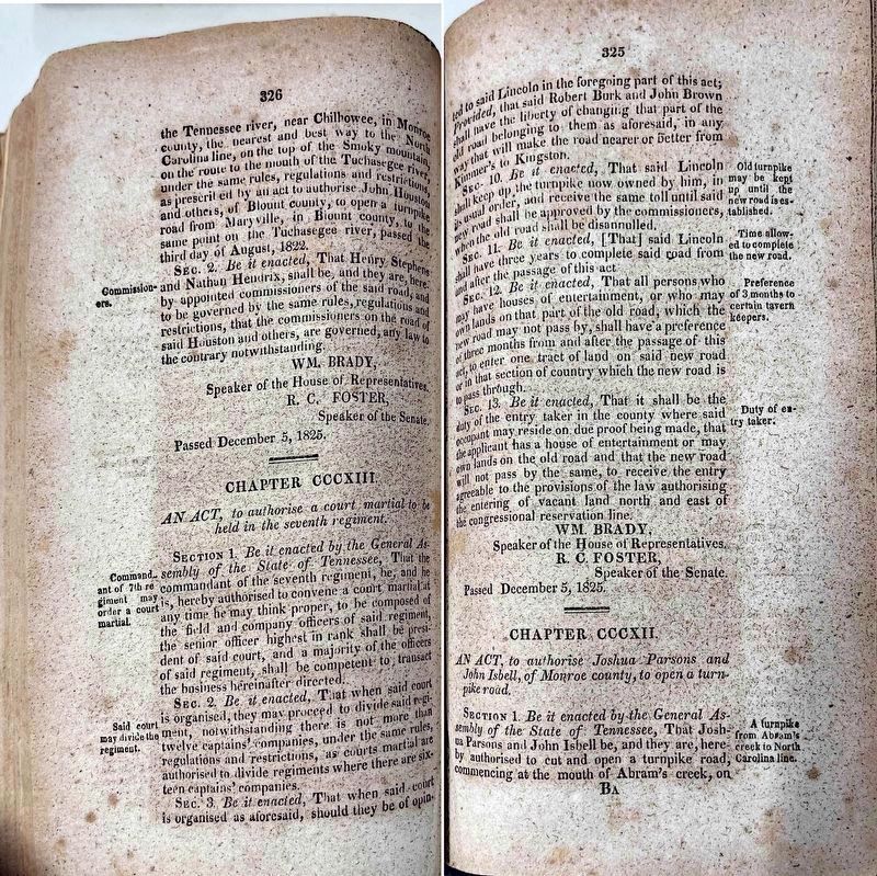
5. Act of the 1825 Tennessee General Assembly Authorizing the Completion of the Turnpike
Follow this link to download a three page PDF.
Click for more information.
Click for more information.
Other names in use were Maryville-Franklin Turnpike and Tallassee Turnpike, for the nearby Overhill Cherokee town that was abandoned by the Native Americans in 1819 after the Treaty of Calhoun. An important ford at Tallassee connected trails and roads on both sides of the Little Tennessee River.
This turnpike continued operation as a toll road into the 20th century. The last private turnpike in Tennessee ceased operation in 1926, after the legislature allowed and then required takeover by county governments for conversion to public roads. On June 23, 1930 more than a hundred people drove from East Tennessee to Robbinsville NC “to join the people of Graham County in celebration of the opening of the new [crushed stone] highway connecting Robbinsville with Maryville.” This section of highway, largely following the old turnpike, was designated as part of US Highway 129 in 1934.
— Submitted January 18, 2025, by Martin Webster of New Market, Tennessee.

Robert Edward Davis (Licensed from Shutterstock.com), circa 2024
6. Contemporary Photograph of U.S. 129 in this Vicinity
Credits. This page was last revised on May 27, 2025. It was originally submitted on January 17, 2025, by Martin Webster of New Market, Tennessee. This page has been viewed 1,442 times since then and 29 times this year. Photos: 1, 2. submitted on January 17, 2025, by Martin Webster of New Market, Tennessee. 3. submitted on January 17, 2025, by J. J. Prats of Powell, Ohio. 4, 5. submitted on January 19, 2025, by Martin Webster of New Market, Tennessee. 6. submitted on January 19, 2025, by J. J. Prats of Powell, Ohio. • J. J. Prats was the editor who published this page.
