Tipton in Moniteau County, Missouri — The American Midwest (Upper Plains)
Tipton

Photographed by William Fischer, Jr., January 22, 2012
1. Tipton Marker
Historic town in the annals of western transportation, Tipton, in 1858-59, was the eastern stagecoach terminus of the famous Butterfield Overland Mail. N.Y. expressman John Butterfield (1801-69), under contract to carry mail and passengers between St. Louis and San Francisco over the Southern Route on a twice-a-week, 25-day schedule, used Tipton as stage terminus because the Pacific R. R. (Mo. Pac.), completed to this point, could be used for the first 160 miles.
The first westbound mail and passengers carried by Butterfield stage left Tipton, Sept. 16, 1858, and arrived in San Francisco 24 days later after traveling some 2,700 miles across rivers, deserts, mountains, and through hostile Indian territory. At one time Butterfield had 1,500 horses and mules, 100 coaches, relay stations about 20 miles apart, and, at the peak, 2,000 employees.
Tipton was replaced as terminus when the railroad reached nearby Syracuse in the summer of 1859. In 1861, because of the Civil War, traffic was transferred from the Southern to the Central Route.
(See other side)
Reverse
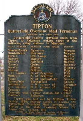
(Continued from other side)
Butterfield coaches traveled south
this page online
making stops at the following relay stations in Missouri:
Relay Station • Nearest Town Today • County
Shackelford's • Syracuse • Morgan
Munhollen's • Florence • Morgan
Burn's • Cole Camp • Benton
Warsaw • Warsaw • Benton
Bailey's • Fairfield • Benton
Quincy • Quincy • Hickory
Yoast's • Elkton • Hickory
Bolivar • Bolivar • Polk
J. H. Smith's • N. of Brighton • Polk
Molloy's • S. of Brighton • Polk
Evans' • N. of Springfield • Greene
Springfield • Springfield • Greene
Ashmore's • N. W. corner of • Christian
J. I. Smith's • N. E. corner of • Barry
Crouch's • Cassville • Barry
Cassville (not a relay station but a stop)
Harbin's • Seligman • Barry
Tipton was laid out by William Tipton Seeley, 1858, shortly before it became the Butterfield Overland Mail terminus. Near Tipton is the State Training School for Negro Girls, opened, 1916.
Erected 1955 by State Historical Society of Missouri and State Highway Commission.
Topics and series. This historical marker is listed in these topic lists: African Americans • Communications • Roads & Vehicles • Settlements & Settlers. In
Photographed by William Fischer, Jr., January 22, 2012
2. Tipton Marker Reverse
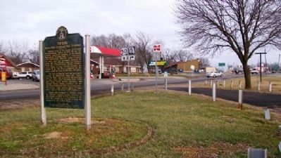
Location. 38° 39.182′ N, 92° 47.185′ W. Marker is in Tipton, Missouri, in Moniteau County. It is on U.S. 50 west of Walnut Street, on the left when traveling west. The marker is at a roadside turnout. Touch for map. Marker is at or near this postal address: 331 U.S Highway 50, Tipton MO 65081, United States of America. Touch for directions.

Regionally, this marker is in the Missouri River Corridor. It is also in the American Ozarks, in the Lewis & Clark Corridor, and in the Corn Belt. Globally, it is in North America, the Western Hemisphere, the Western World, and the Anglosphere. Historically, it finds itself in what was once the territory of the Mississippian Culture, the Louisiana Purchase, and the Antebellum South.
Other nearby markers. At least 7 other markers are within 5 miles of this marker, measured as the crow flies: Tipton Methodist Church Bell (approx. 0.4 miles away); William Tipton Seely (approx. half a mile away); First Presbyterian Church (approx. half a mile away); The Maclay Home (approx. half a mile away); Site of First St. Andrew Catholic Church (approx. 0.7 miles away); Harrison School (approx. 0.7 miles away); Butterfield Overland Mail in Missouri - 1858-1861 (approx. 4.9 miles away).
Also see . . .
1. BONESHAKER: The Saga of the Butterfield Overland Mail. Missouri Life Magazine website entry (Submitted on June 3, 2022, by Larry Gertner of New York, New York.)
2. Butterfield Overland Mail. Handbook of Texas website entry (Submitted on January 9, 2013, by William Fischer, Jr. of Reynoldsburg, Ohio.)
3. A grave injustice : institutional terror at the State Industrial Home for Negro girls (Rowe).
Photographed by William Fischer, Jr., January 22, 2012
3. Tipton Marker
Photographed by Gregory William Wadley, December 19, 2024
4. Tipton Marker
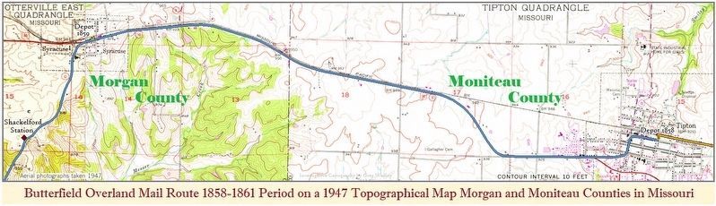
Butterfield Overland Mail Route 1858-1861 period on a 1947 Topographical Map by Greg Wadley

Photographed by 1885 Sanborn Map, Aug 1885
5. Tipton 1885 with location of livery for the Butterfield Overland Mail Route 1858-1861 Period
There was 10 Stable's but only 2 Livery's in town in 1885 making the Livery on Osage Avenue the probable location for the terminus of the Butterfield. It had sheds, a Carriage Paintery, Bridle/Tack Store and a Wagon Shop. The Original Pacific Depot was torched during the raid of Confederate Gen. Shelby 1863. The Interstate Commerce Commission approved the merger of the Union Pacific, Missouri Pacific, and Western Pacific in 1982 becoming MOPAC.
Credits. This page was last revised on February 2, 2025. It was originally submitted on January 9, 2013, by William Fischer, Jr. of Reynoldsburg, Ohio. This page has been viewed 2,739 times since then and 138 times this year. Last updated on January 24, 2025, by Gregory William Wadley of Fremont Hills, Missouri. Photos: 1, 2, 3. submitted on January 9, 2013, by William Fischer, Jr. of Reynoldsburg, Ohio. 4. submitted on December 19, 2024, by Gregory William Wadley of Fremont Hills, Missouri. 5. submitted on January 24, 2025, by Gregory William Wadley of Fremont Hills, Missouri. • J. Makali Bruton was the editor who published this page.
