Ripa in Roma in Città metropolitana di Roma Capitale, Latium, Rome, Italy — Central Italy (Tyrrhenian Coast)
Il Fornice XII
⎯⎯⎯
Vaulted Chamber XII
Photographed by James Hulse, February 27, 2024
1. Il Fornice XII / Vaulted Chamber XII Marker

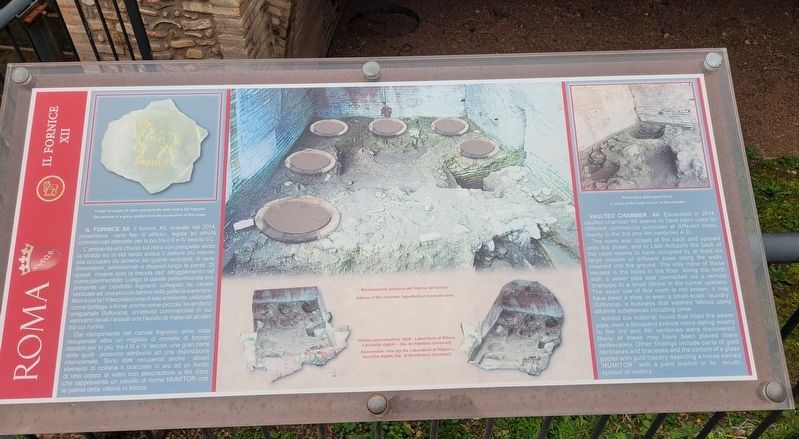
Il Fornice XII. Il fornice XII, scavato nel 2014, presentava varie fasi di utilizzo legate ad attività commerciali attestate per lo più tra il III e IV secolo d.C. L'ambiente era chiuso sul retro con prospetto verso la strada ed in età tardo antica il settore più interno era occupato da almeno sei grandi recipienti, di varie dimensioni, seminterrati e disposti lungo le pareti. Di questi rimane solo la traccia dell'alloggiamento nel piano pavimentale. Lungo la parete settentrionale era presente un condotto fognario collegato da canale verticale ad una piccola latrina nella galleria superiore. Non è certa l'interpretazione di tale ambiente, utilizzato come bottega o forse anche come piccola 'lavanderia' artigianale (fullonica), un'attività commerciale in cui venivano lavati i tessuti con l'ausilio di materiali alcalini tra cui l'urina.
Dal riempimento del canale fognario sono state recuperate oltre un migliaio di monete di bronzo databili per lo più tra il III e IV secolo, una gran parte delle quali possono attribuirsi ad una deposizione intenzionale. Sono stati recuperati anche alcuni elementi di collana
this page online
Didascalie
(Foto #1) Fondo di coppa di vetro proveniente dallo scavo del fognolo
(Foto #2) Ricostruzione ipotetica dell'interno del fornice
(Foto #3) Veduta assonometrica (elab. Laboratorio di Rilievo e tecniche digitali - Dip. Architettura Uniroma3)
(Foto #4) Particolare dell'angolo Nord
Vaulted Chamber XII. Excavated in 2014, vaulted chamber XII seems to have been used for different commercial purposes at different times, mainly in the 3rd and 4th centuries A.D.
The room was closed at the back and opened onto the street, and in Late Antiquity the back of the room seems to have occupied by at least six large vessels of different sizes along the walls, inserted into the ground. The only trace of these vessels is the holes in the floor. Along the north wall, a sewer pipe was connected via a vertical drainpipe to a small latrine in the tunnel upstairs. The exact use of this room is not known; it may have been a shop or even a small-scale 'laundry' (fullonica),

Photographed by James Hulse, February 27, 2024
2. The Vaulted Chamber XII and Marker
Amidst the material found that filled the sewer pipe, over a thousand bronze coins dating mostly to the 3rd and 4th centuries were discovered. Many of these may have been placed there deliberately. Other findings include parts of gold necklaces and bracelets and the bottom of a glass goblet with gold tracery depicting a horse named 'NUMITOR', with a palm branch in its mouth, symbol of victory.
Captions
(Photo #1) The bottom of a glass goblet from the excavation of the sewer
(Photo #2) Interior of the chamber: hypothetical reconstruction
(Photo #3) Axonometric view (by the Laboratorio di Rilievo e tecniche digitali, Dip. di Architettura Uniroma3)
(Photo #4) A detail of the north corner of the chamber
Erected by Rome.
Topics. This historical marker is listed in this topic list: Anthropology & Archaeology. A significant historical year for this entry is 2014.
Location. 41° 53.098′ N, 12° 29.319′ E. Marker is in Roma, Lazio (Latium, Rome), in Città metropolitana di Roma Capitale. It is in Ripa. It is at the intersection of Viale Aventino and Via del

Photographed by James Hulse, February 27, 2024
3. The Vaulted Chamber XII and Marker

Regionally, it is in Europe, the European Union, the Schengen Area, a coastal Mediterranean country, and the Western World. Historically, it finds itself in what was once the Roman Empire.
Other nearby markers. At least 8 other markers are within walking distance of this marker: Le Latrine / The Latrines (here, next to this marker); Circo Massimo (here, next to this marker); L'Età Moderna / The Modern Age (a few steps from this marker); L'Emiciclo / The Hemicycle (within shouting distance of this marker); Il Mulino e le Macine / The Mill and the Millstones (within shouting distance of this marker); La Torre della Moletta / The Moletta Tower (within shouting distance of this marker); Frammenti Dell'Arco di Tito / Fragments From the Arch of Titus (within shouting distance of this marker); L'Arco di Tito / The Arch of Titus (within shouting distance of this marker). Touch for a list and map of all markers in Roma.
More about this marker. There is a small entry fee to visit the Circus Maximus Archaeological Site.
Also see . . . Circus Maximus. Wikipedia
The Circus Maximus (Latin for "largest circus"; Italian: Circo Massimo) is an ancient Roman chariot-racing stadium and mass entertainment venue in Rome, Italy. In the valley between the Aventine and Palatine hills, it was the first and largest stadium in ancient Rome and its later Empire. It measured 621 m (2,037 ft) in length and 118 m (387 ft) in width and could accommodate over 150,000 spectators. In its fully developed form, it became the model for circuses throughout the Roman Empire.(Submitted on February 5, 2025, by James Hulse of Medina, Texas.)
Credits. This page was last revised on February 6, 2025. It was originally submitted on February 5, 2025, by James Hulse of Medina, Texas. This page has been viewed 114 times since then and 9 times this year. Photos: 1, 2, 3. submitted on February 6, 2025, by James Hulse of Medina, Texas.
